In Brief:
Small snow chances continue then pick up Tuesday PM into Wednesday AM.
Tuesday PM update:
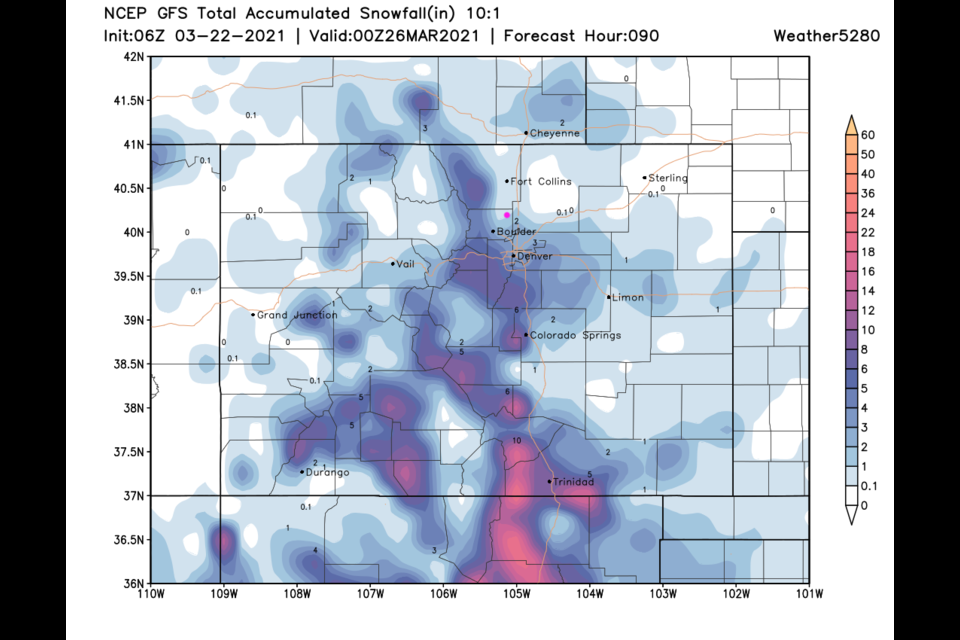
A minor system is moving in with a disjointed trough aloft drifting through the West. An inch or two of snow is possible along I-25 with more like 8-12 inches in the higher elevations and southern mountains (Figure 4 update). It may make things slick in the AM Wednesday.
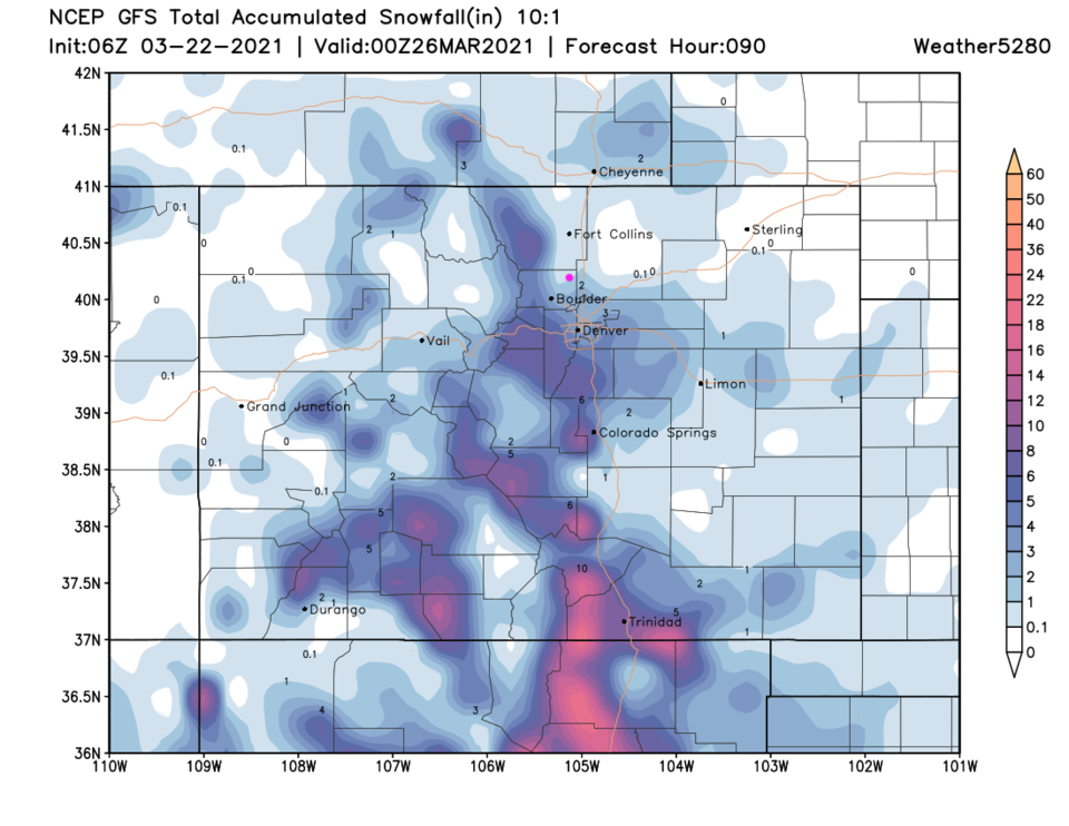 Figure 4 update: GFS snowfall total forecast through Thurs PM from weather5280.com
End Tuesday update.
Monday PM update:
We received about 1.5 to 2.5 inches of snow across Longmont in yesterday's storm. Boulder received just under 2 inches up to 4 inches (Figure 2 update).
Unsettled weather remains with the next system already beginning to make snow fall in the mountains. Small chances of snow continue until Tuesday afternoon when snow chances pick up again. By Wednesday PM, we might see 1-2 inches more fall (Figure 3 update).
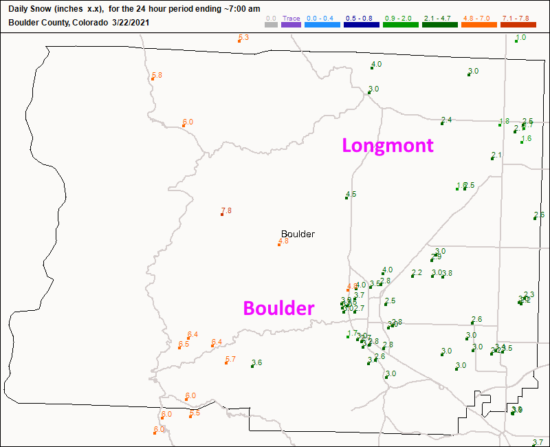 Figure 2 update: the CoCoRaHS snowfall reports up to 7am today.
 Figure 3 update: the GFS snowfall forecast (10:1 ratio) through Wednesday PM from weather5280.com
End Monday PM update.
Sunday PM Update:
Just jumping in with the High Resolution Rapid Refresh model that only forecasts 15 hours in advance. That takes us to about the expected end of precipitation Monday morning. Longmont has received about 1/2 inch of snow (that started a few hours earlier than I expected). The HRRR (Figure 1 update) gives us 1-2 inches more overnight. Not too bad.
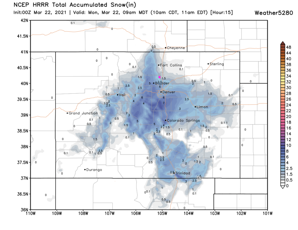 Figure 1 update: the HRRR model snowfall through 9am from weather5280.com
End of the Sunday PM update.
Forecast Discussion:
Let's start with the NWS - they downgraded the Winter Storm Watch to:
...WINTER WEATHER ADVISORY IN EFFECT FROM 6 PM THIS EVENING TO NOON
MDT MONDAY...
* WHAT...Snow expected. Total snow accumulations of 3 to 6 inches.
* WHERE...Boulder and the western suburbs of Denver, and Denver.
* WHEN...From 6 PM this evening to Noon MDT Monday.
* IMPACTS...Plan on slippery road conditions. The hazardous conditions could impact the Monday morning commute.
PRECAUTIONARY/PREPAREDNESS ACTIONS...
Slow down and use caution while traveling. The latest road conditions for Colorado can be obtained by calling 511 or by going to www.cotrip.org
________________________________________
A progressive pattern is setting up with repeated troughs passing over the state every couple of days or so. The rain/snow chances on Figure 1 over the next 10 days look like a heart beat. Our first system in this series shows the best precipitation chances begin after noon today and extend into the mid-morning Monday. The change to a snow/rain mix should arrive around 5-6 p.m. with a chance to all snow by 7-8 p.m. Monday morning looks quite snowy over much of the state (Figure 2). This will make the Monday morning commute dicey to difficult.
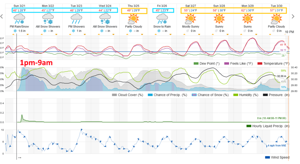 Figure 1: the 10 day graphical forecast from weatherunderground.com for Longmont, CO.
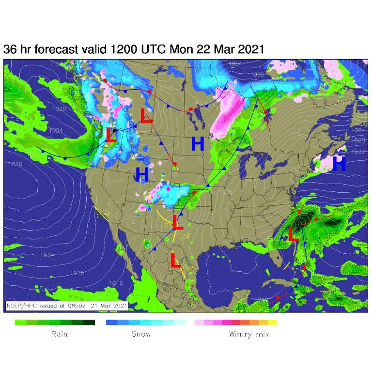 Figure 2: the surface forecast analysis for Monday AM from NCEP.
Snowfall Roundup:
Through noon Monday we see the following predicted totals:
The weatherunderground model (Figure 1), 1-2 inches.
The GFS model (Figure 2), 2-4 inches. We should receive 1/4 to 1/2 inch of liquid in this system (Figure 3).
The NAM model (Figure 4), 1-3 inches.
The NWS (in their advisory), 3-6 inches.
The forecasters at weather5280.com, 2-6 inches.
Note there will be a strong gradient east to west. Slightly higher elevations in the foothills will pick up high end snow amounts where locations east of U.S.25 will see much less.
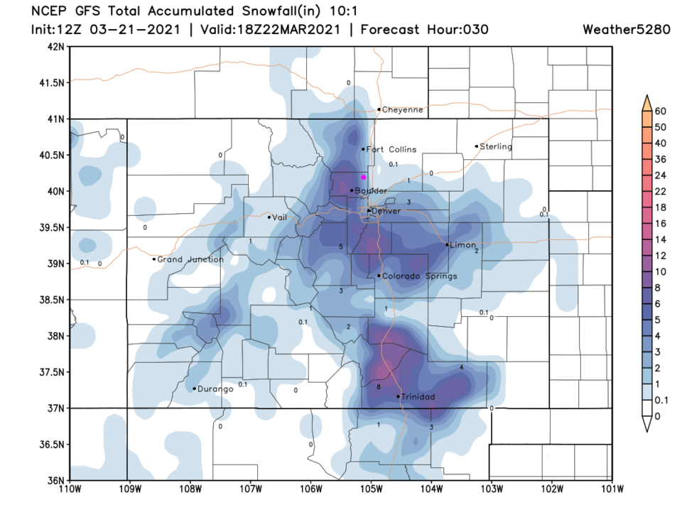 Figure 3: the 3 day (10:1 ratio) total snowfall forecast from the GFS and weather5280.com
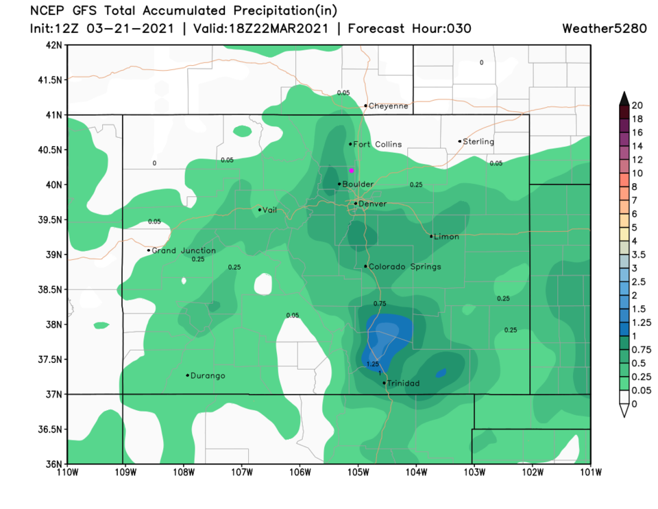 Figure 4: the 3 day (10:1 ratio) total rainfall forecast from the GFS and weather5280.com
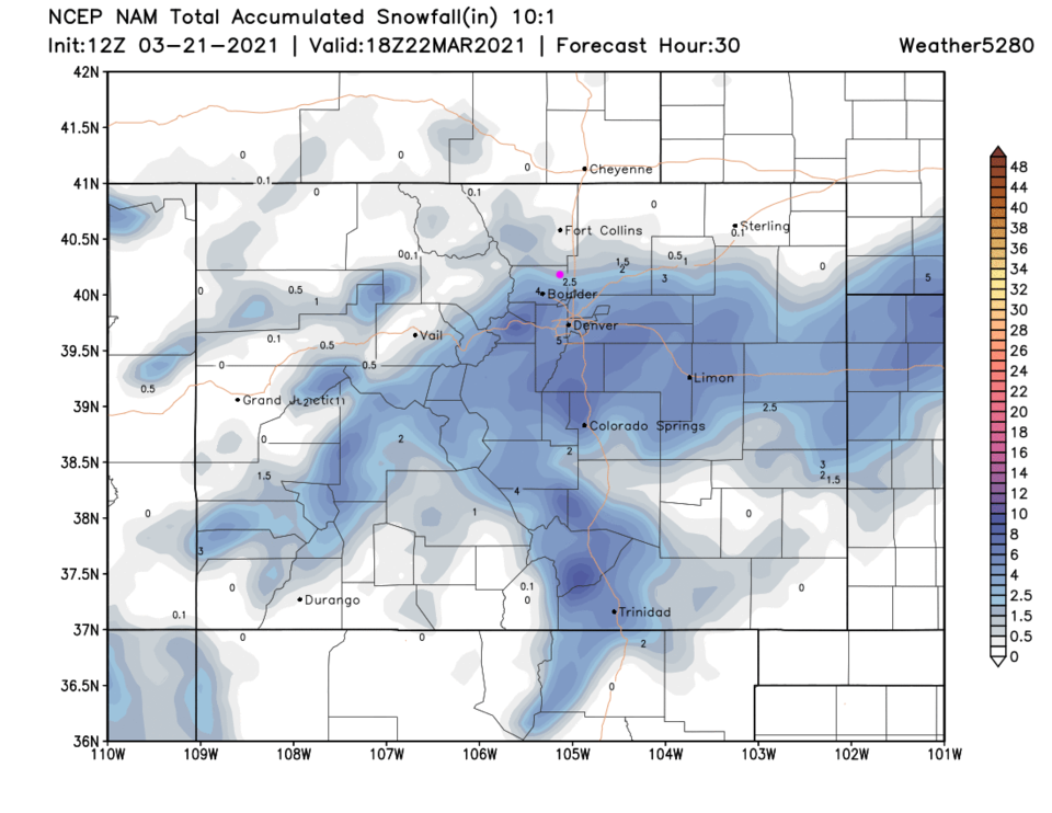 Figure 5: the 3 day (10:1 ratio) total snowfall forecast from the NAM and weather5280.com
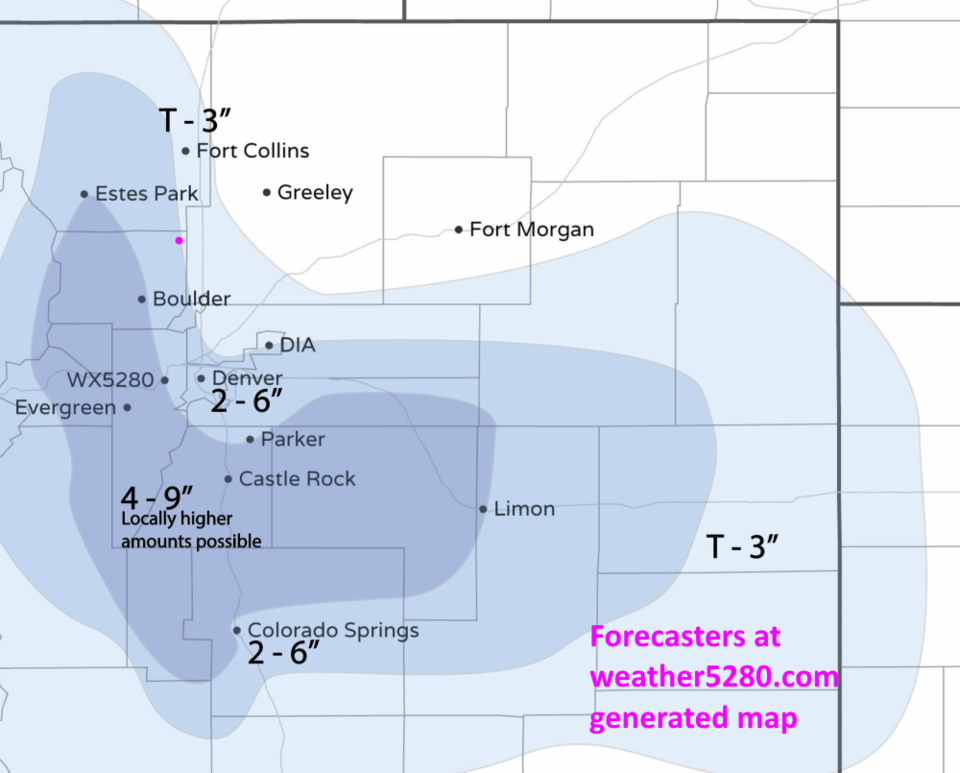 Figure 6: the snowfall forecast made by the forecasters at weather5280.com
The Longer Range Forecast:
Looking quickly out at the next 10 days, the GFS gives Longmont about 5-10 inches over these 3-4 next storms. Temperatures are never really cold this week meaning that rainfall is likely in the daytime.
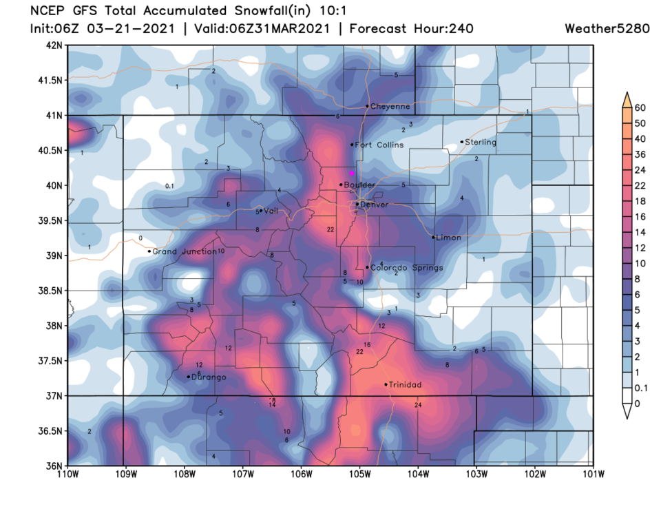 Figure 7: the 10 day (10:1 ratio) total snowfall forecast from the GFS and weather5280.com


