Skip to content
Join our Newsletter

Monday Update: The Front Range Forecast: Bitter cold and some snow

Monday morning update:

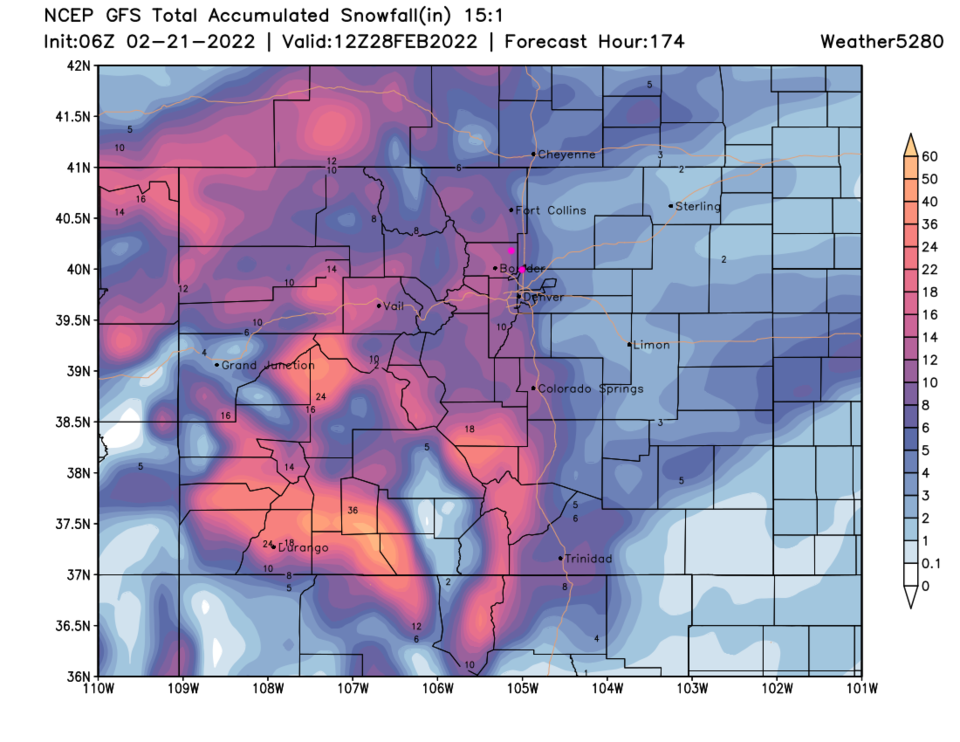
I know everyone wants to know snowfall totals, but the big story with this system is the prolonged cold. Let's talk about the snow though - from Longmont to Broomfield we should see about 1-2 inches a day Monday to Wednesday. Areas east of I-25 will see very little show while the foothills will see 9-12 inches over the week according to the 'fluffier' 15:1 snowfall ratio map from the GFS (Figure 1 update).

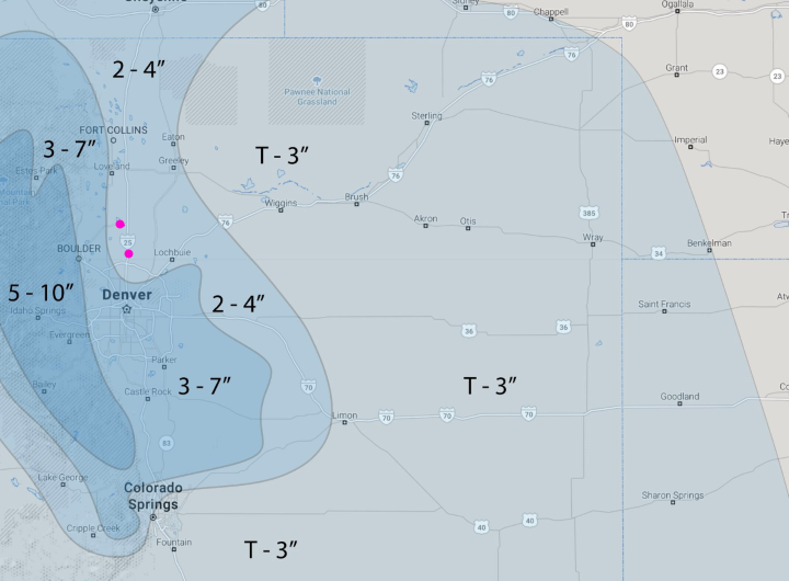
The forecasters at weather5280.com (Figure 2 update) don't go that high, but give the Longmont-Broomfield region 2-4 inches. The roads along I-25 shouldn't get bad, often, since there will be just a little snow each day, and it will be very 'dry' due to the low temperatures.

The cold front should sweep down the state between noon and 2 p.m. (dashed line Figure 3 update). We won't get back to freezing until Saturday midday next weekend. I expect single-digit highs Tuesday and 2-3 nights below zero lows Tue/Wed/Thur. With a stiff breeze at times, wind chills will be very painful and dangerous. As I write, we do not have any weather statements, watches, or warnings along I-25 or even up in Estes Park. Still - stay warm!


Figure1u_02212022
Figure 1 update: the 15:1 snowfall total forecast from the GFS and weather5280.com for the next 7 days.
Figure2u_02212022
Figure 2 update: the hand-drawn storm snowfall forecast from the forecasters at weather5280.com
Figure3u_02212022
Figure 3 update: the 10 day graphical forecast for Broomfield from weatherunderground.com


About the Author: John Ensworth

John Ensworth used to work from Longmont as the PI for the NASA through the IGES (The Institute for Global Environmental Strategies). He now teaches technology, algebra, astronomy, meteorology, film school, and Lego robotics to middle/high school.
Read more


Comments


Current Weather

Mostly cloudy

Mostly cloudy

87°F

UV Index
3 Moderate
Pressure
30.02 Steady
Visibility
6 miles
Dewpoint
49 °F
Humidity
27%
Wind
NNE 4.5 mph
Gust
10.5 mph
Wind Chill
87 °F

Hourly Forecast

Today
4 PM
88°F
Intermittent clouds
Today
5 PM
87°F
Thunderstorms
Today
6 PM
84°F
Intermittent clouds
Today
7 PM
82°F
Intermittent clouds
Today
8 PM
78°F
Cloudy
Today
9 PM
74°F
Cloudy
Today
10 PM
71°F
Cloudy
Today
11 PM
68°F
Mostly cloudy
Tomorrow
12 AM
66°F
Mostly cloudy
Tomorrow
1 AM
65°F
Mostly cloudy
Tomorrow
2 AM
64°F
Mostly cloudy
Tomorrow
3 AM
64°F
Mostly cloudy

7 Day Forecast

Mostly cloudy w/ t-storms

Saturday

90 °F

Turning cloudy and not as hot; a stray thunderstorm this afternoon


Mostly cloudy

Saturday Night

60 °F

Mostly cloudy


Mostly cloudy w/ t-storms

Sunday

74 °F

Not as warm with variable cloudiness; widely separated thunderstorms in the afternoon


Clear

Sunday Night

54 °F

Clear


Mostly sunny

Monday

84 °F

Sunny to partly cloudy and warmer


Partly cloudy

Monday Night

55 °F

Partly cloudy


Intermittent clouds

Tuesday

89 °F

A blend of sun and clouds


Partly cloudy

Tuesday Night

56 °F

Partly cloudy; good conditions for viewing the meteor shower


Mostly sunny

Wednesday

93 °F

Mostly sunny and very warm


Partly cloudy

Wednesday Night

58 °F

Partly cloudy


Sunrise and Sunset

Sunrise
6:06 AM
Sunset
8:05 PM

Based on AccuWeather data