Skip to content

The Next Storm/Next Snow Forecast Discussion from the Cherrywood Observatory – February 18 , 2018

This content was originally published by the Longmont Observer and is licensed under a Creative Commons license.

Forecast Discussion:

In a stunning turn of events... the Monday snow storm (and extreme cold event) is BACK!

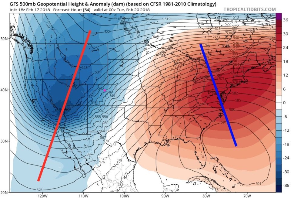
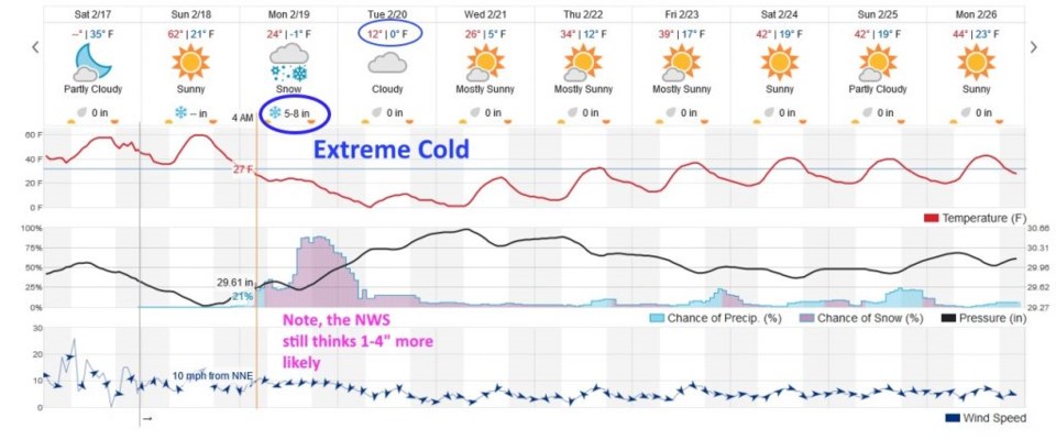
Before that, we need to look at the wind and heat (and there is a distinct fire danger for later today). Figure 1 gives you an overlook at the next 10 days.  We are back to the mid-60's locally for today.  We have a ridge overhead (blue line in Figure 2) and stiff down slope winds along the Front Range (Figure 3).  This will result in temperatures on the eastern Plains of Colorado some 12-14 degrees F above normal.  Get your yard work done!

Figure 1: The 10 day graphical forecast from weatherunderground.com

Figure 2: The 500mb map height anomaly for Sunday morning from tropical tidbits (ridges in blue lines, troughs in red lines).

Figure 3: surface wind speeds from tropical tidbits and the GFS for Sunday midday.

Figure 4: The surface temperature anomaly (difference from normal) for Sunday morning from tropical tidbits (reds above normal, blue/purple below normal).

The longer range forecast:

Then a cold front moves in Sunday night around 10pm or so.  Shallow, but very cold air, will move in and low clouds, freezing fog and freezing drizzle are possible Monday morning (visible as a low chance of precipitation and temperatures plummeting below freezing into early morning Monday). Figure 1 shows the temperatures dropping all day Monday and morning snow chances become a good chance of snow after noon as the jet stream moves into place.

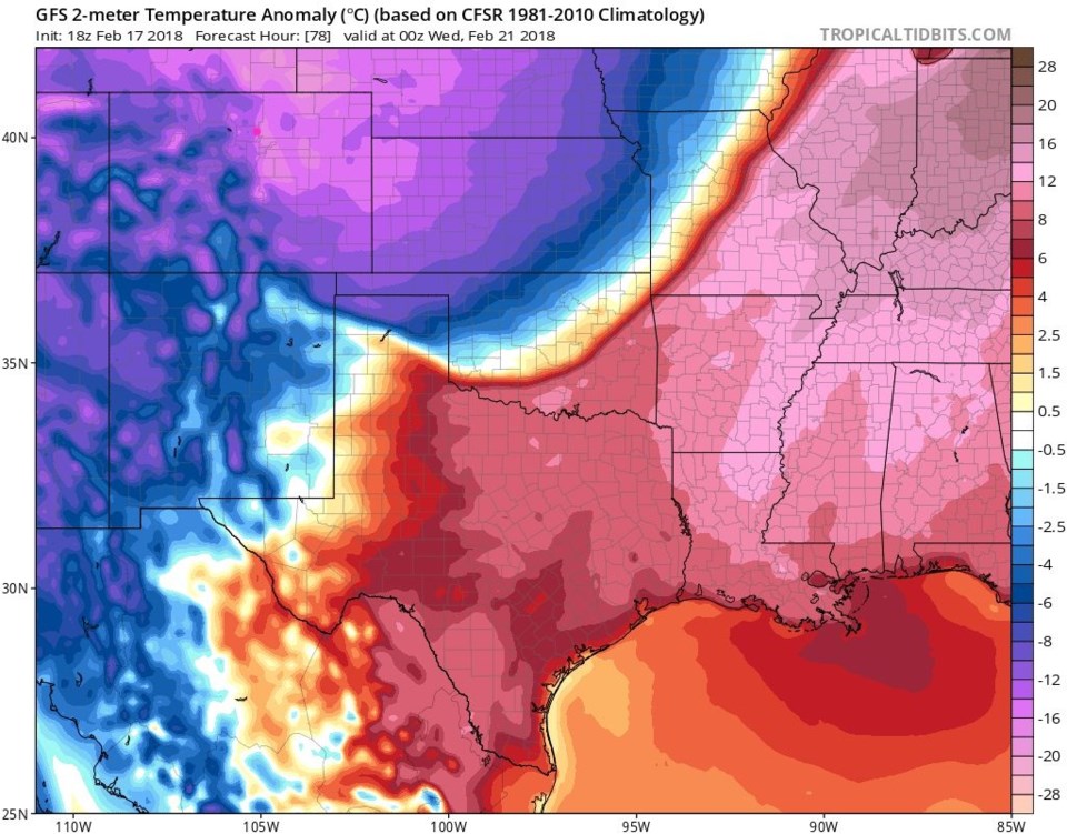
Figure 5 shows how the upper air pattern changes from Figure 2 by Monday night.  A DEEP trough will power our storm, the jet stream, and bring in extremely cold air. Figure 6 graphically shows this amazing cold air by Tuesday PM. Temperatures are now around 16 to 20 degrees F below normal.

The jet stream will create banded snow events for places.  IF Longmont ends up under a band (as is shown on THIS run of the GFS in Figure 7 as thin green lines) then we get 5-6 inches of snow. IF we end up between bands, like areas north of Fort Collins or south of Denver, we only get 1-3" of snow.

Figure 8 is the NAM version, and there is banded snow here too, but we are in the 2-3 inch area on this run.  This will change as the next couple of days go by - and where the bands actually set up may not be clear until the storm starts producing heavier snows midday Monday.  Nonetheless, back to Figure 1, snow chances drop by early Tuesday morning, but some flurries may keep falling into Tuesday night, highs get almost stuck in the single digits and lows below zero are likely.  Bundle up and tune in tomorrow for more!

Figure 5: The 500mb map height anomaly for Monday night from tropical tidbits (ridges in blue lines, troughs in red lines).

Figure 6: The surface temperature anomaly (difference from normal) for Monday night from tropical tidbits (reds above normal, blue/purple below normal).

Figure 7: Total snowfall from the GFS forecast between Saturday night and Wednesday AM from weather5280.com. Snowbands in light green.

Figure 7: Total snowfall from the NAM forecast between Saturday night and Wednesday AM from tropicaltidbits. Snow bands highlighted in light green.

Current Weather

Mostly clear

Mostly clear

47°F

UV Index
0 Low
Pressure
29.96 Rising
Visibility
8 miles
Dewpoint
40 °F
Humidity
75%
Wind
NE 1.7 mph
Gust
4 mph
Wind Chill
47 °F

Hourly Forecast

Today
10 PM
47°F
Partly cloudy w/ showers
Today
11 PM
46°F
Intermittent clouds
Tomorrow
12 AM
44°F
Partly cloudy
Tomorrow
1 AM
43°F
Partly cloudy
Tomorrow
2 AM
42°F
Partly cloudy
Tomorrow
3 AM
41°F
Partly cloudy
Tomorrow
4 AM
39°F
Partly cloudy
Tomorrow
5 AM
38°F
Partly cloudy
Tomorrow
6 AM
37°F
Partly cloudy
Tomorrow
7 AM
40°F
Partly sunny
Tomorrow
8 AM
44°F
Mostly sunny
Tomorrow
9 AM
50°F
Mostly sunny

7 Day Forecast

Intermittent clouds

Sunday

64 °F

Warmer with times of clouds and sun


Partly cloudy w/ showers

Sunday Night

37 °F

A brief evening shower or two; otherwise, partly cloudy


Partly sunny

Monday

70 °F

Partly sunny and pleasant


Intermittent clouds

Monday Night

43 °F

Partly cloudy


Mostly sunny

Tuesday

73 °F

Mostly sunny and pleasant


Intermittent clouds

Tuesday Night

41 °F

Clearing


Intermittent clouds

Wednesday

65 °F

Times of sun and clouds


Intermittent clouds

Wednesday Night

39 °F

A thundershower in spots in the evening; otherwise, partly cloudy


Rain

Thursday

53 °F

Cooler with occasional rain and drizzle; breezy in the morning


Partly cloudy

Thursday Night

32 °F

Partly cloudy


Sunrise and Sunset

Sunrise
6:03 AM
Sunset
7:53 PM

Based on AccuWeather data