Skip to content

The Next Storm/Next Snow Forecast Discussion from the Cherrywood Observatory – February 21 , 2018

This content was originally published by the Longmont Observer and is licensed under a Creative Commons license.

Forecast Discussion:

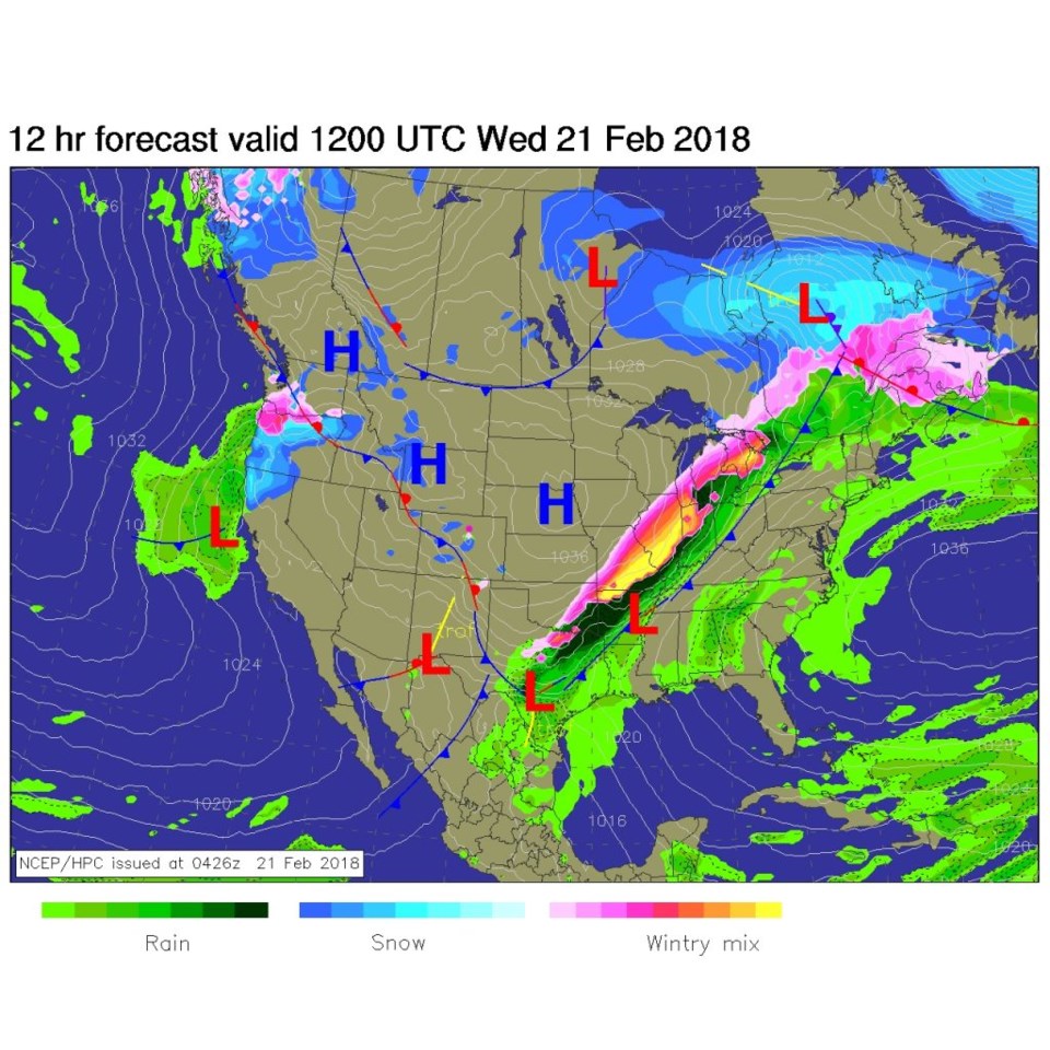
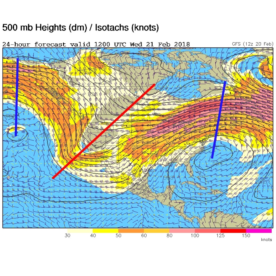
We are still cold.  (I'm not going to tell you the current temperature in D.C., but it rhymes with 64F - the high out here tomorrow rhymes with 78F). Figure 1 shows the stationary front to our west.  Figure 2 is the upper air pattern with a deep trough over the west and jet stream energy to the south of the state.  Any little disturbance traveling through will kick off snow in the mountains and snow flurries on the low lands.

Figure 1: The forecast surface map from NCEP for this morning (Wednesday).

Figure 2: The upper air forecast 500mb map from the GFS.

The longer range forecast:

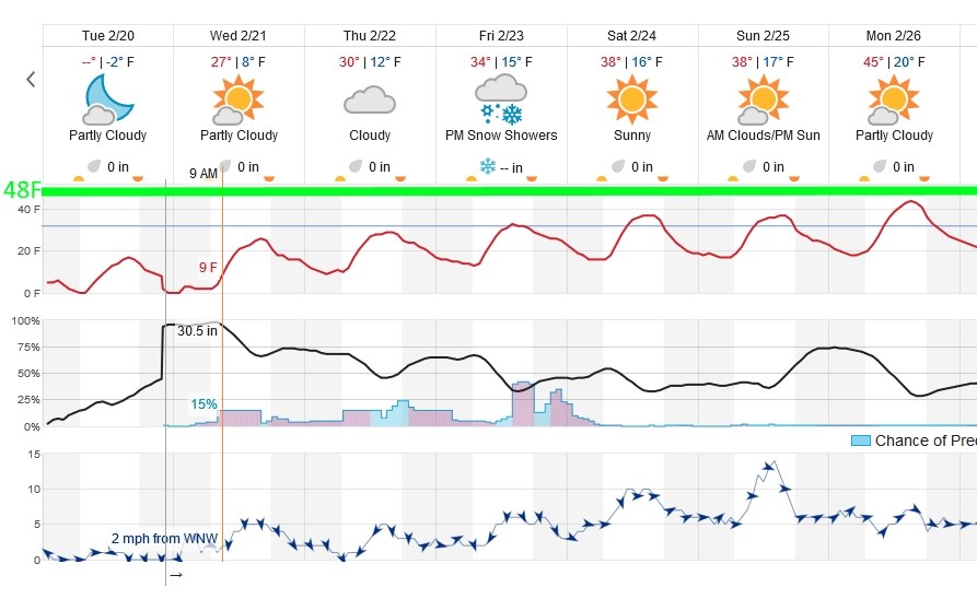
With the pattern changing little until Saturday- we stay below the normal high temperature for this time of year (48F - the thick green line in Figure 3).  The almost constant, but slight, chance of snow is plotted here as well. A slightly better chance of snow for everyone returns on Friday- as the front returns as a warm front and passes across the state with the departing trough.

Figure 3: A portion of the 10 day graphical forecast map from weatherunderground.com

Current Weather

Sunny

Sunny

61°F

UV Index
0 Low
Pressure
29.93 Falling
Visibility
8 miles
Dewpoint
38 °F
Humidity
41%
Wind
NNW 3.2 mph
Gust
6.4 mph
Wind Chill
61 °F

Hourly Forecast

Today
8 PM
60°F
Mostly cloudy w/ showers
Today
9 PM
57°F
Intermittent clouds
Today
10 PM
54°F
Mostly clear
Today
11 PM
51°F
Mostly clear
Tomorrow
12 AM
49°F
Mostly clear
Tomorrow
1 AM
48°F
Mostly clear
Tomorrow
2 AM
46°F
Mostly clear
Tomorrow
3 AM
45°F
Mostly clear
Tomorrow
4 AM
43°F
Mostly clear
Tomorrow
5 AM
42°F
Mostly clear
Tomorrow
6 AM
39°F
Mostly sunny
Tomorrow
7 AM
41°F
Mostly sunny

7 Day Forecast

Intermittent clouds

Saturday

64 °F

Cooler with clouds giving way to some sun


Mostly clear

Saturday Night

39 °F

A shower in spots this evening; otherwise, clear to partly cloudy


Mostly cloudy

Sunday

78 °F

Cloudy most of the time, breezy and warmer


Mostly cloudy

Sunday Night

47 °F

Rather cloudy and windy


Windy

Monday

60 °F

Very windy; cloudy and cooler


Intermittent clouds

Monday Night

41 °F

Partly cloudy


Intermittent clouds

Tuesday

59 °F

Cool with times of clouds and sun; windy in the afternoon


Partly cloudy

Tuesday Night

32 °F

Partly cloudy


Intermittent clouds

Wednesday

60 °F

Times of clouds and sun


Intermittent clouds

Wednesday Night

35 °F

Partly cloudy


Sunrise and Sunset

Sunrise
5:55 AM
Sunset
7:59 PM

Based on AccuWeather data