Skip to content

The Next Storm/Next Snow Forecast Discussion from the Cherrywood Observatory – February 8 , 2018

This content was originally published by the Longmont Observer and is licensed under a Creative Commons license.

Forecast Discussion:

We looked at the upper air patterns yesterday. Now let's get into the details. With gusty down slope winds and warming from the ridge side of the jet stream, we'll crack temperatures above 60F today.  Starting tomorrow, odd and unpleasant things begin to happen...

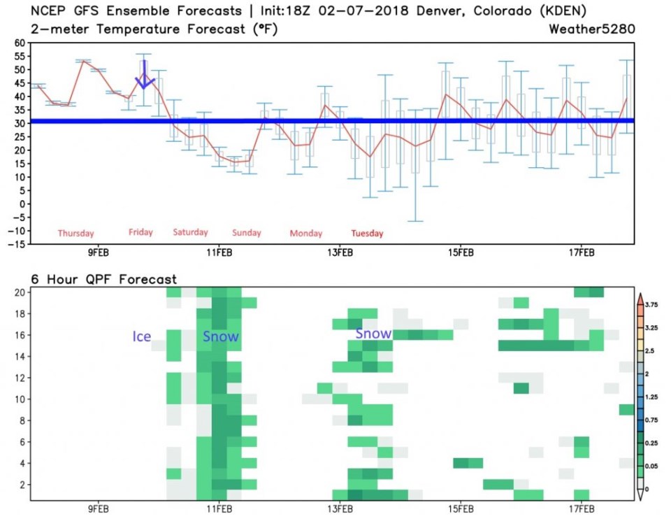
Figure 1 is the 10 day graphical look (and precipitation ensemble) for Denver.  The National Weather Service expects the Friday temperatures to be much lower than the models are predicting (so I drew a downward pointing blue arrow on Friday).  With some up slope flow and that very thin and very cold air, we might see periods of ice and freezing drizzle on Friday into Saturday morning.

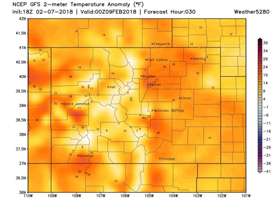
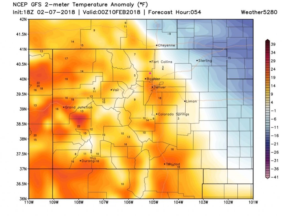
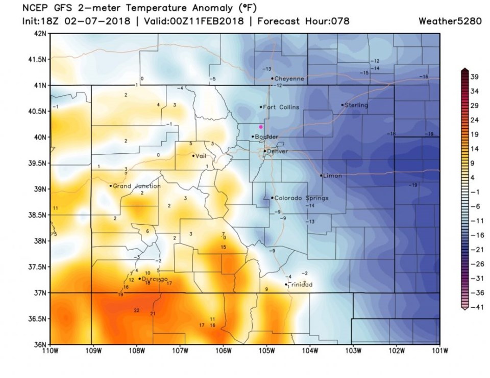
Figure 2 shows how warm the air is above normal on Thursday (today).  Figure 3, for Friday, shows the shallow cold air coming in colored blue.  Expect that to push up into the lower foothills further west than depicted here.  Friday might be a difficult day to get around.

Figure 4, for Saturday, shows the cold air at near maximum invasion. It should be thick enough for a change to snow (still very light snow) for the weekend.

Figure 1: The 10 day graphical forecast from weather5280.com and the GFS for Denver. Freezing is the thick blue line.

Figure 2: The surface temperature anomaly for Thursday PM from weather5280.com and the GFS. Longmont is the pink dot.

Figure 3: The surface temperature anomaly for Friday PM from weather5280.com and the GFS. Longmont is the pink dot.

Figure 4: The surface temperature anomaly for Saturday PM from weather5280.com and the GFS. Longmont is the pink dot.

The longer range forecast:

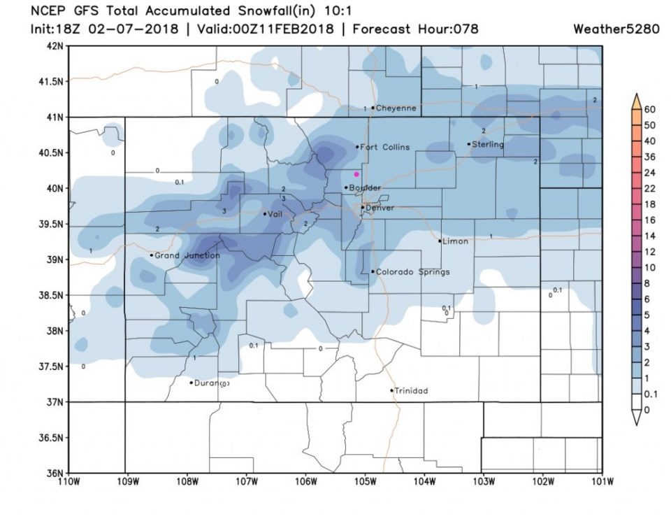
Saturday's storm has not completely vanished from the forecast yet... the GFS paints us in the 1-2" area for earlier and midday Saturday - Figure 5.

Back to Figure 1 - we return to normal-ish temperatures by Monday then the next system moves in. Most model runs do give us snow on Tuesday. We'll wait until after the Saturday storm to put numbers on this one though.

Figure 5: The snowfall total forecast between Wednesday PM and Saturday PM from weather5280.com and the GFS. Longmont is the pink dot.

Current Weather

Mostly cloudy

Mostly cloudy

49°F

UV Index
0 Low
Pressure
29.6 Steady
Visibility
8 miles
Dewpoint
18 °F
Humidity
29%
Wind
W 5.3 mph
Gust
11.9 mph
Wind Chill
47 °F

Hourly Forecast

Today
3 AM
46°F
Mostly clear
Today
4 AM
44°F
Partly cloudy
Today
5 AM
43°F
Intermittent clouds
Today
6 AM
42°F
Mostly cloudy
Today
7 AM
44°F
Cloudy
Today
8 AM
46°F
Partly sunny w/ showers
Today
9 AM
51°F
Partly sunny
Today
10 AM
54°F
Intermittent clouds
Today
11 AM
56°F
Intermittent clouds
Today
12 PM
58°F
Mostly cloudy
Today
1 PM
59°F
Showers
Today
2 PM
61°F
Intermittent clouds

7 Day Forecast

Showers

Monday

57 °F

A few showers in the morning; otherwise, mostly cloudy, breezy and cooler


Intermittent clouds

Monday Night

42 °F

Partly cloudy; breezy late


Partly sunny w/ showers

Tuesday

61 °F

Very windy; a couple of showers this morning; otherwise, times of clouds and sun


Partly cloudy

Tuesday Night

34 °F

Partly cloudy


Intermittent clouds

Wednesday

57 °F

Cool with times of clouds and sun


Mostly cloudy

Wednesday Night

39 °F

Increasing clouds


Partly sunny w/ showers

Thursday

56 °F

Times of clouds and sun with a couple of showers; cool


Cloudy

Thursday Night

40 °F

Cloudy


Mostly cloudy

Friday

66 °F

Mostly cloudy and warmer


Mostly clear

Friday Night

40 °F

Mainly clear


Sunrise and Sunset

Sunrise
5:53 AM
Sunset
8:01 PM

Based on AccuWeather data