Skip to content

The Next Storm/Next Snow Forecast Discussion from the Cherrywood Observatory – February 9 , 2018

This content was originally published by the Longmont Observer and is licensed under a Creative Commons license.

Forecast Discussion:

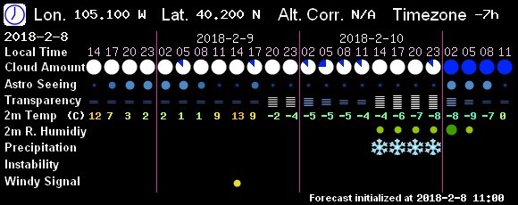
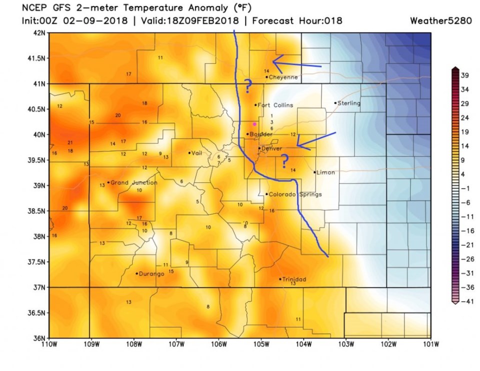
The heat ends and the next cold front moves in around dawn today (this post goes live at 1am).  From Figure 1, you can see that the warmest temperature for today happened a minute after midnight.  Figure 2 shows the departure from normal -cold temperatures in blue -for midday today.  The NWS expects that cold air to bump up against the foot of the foothills (my blue line and question marks).  Where low clouds form, mainly north of Denver and possibly around Longmont or I-25 and then eastward, there will be periods of freezing drizzle. If it gets dark outside, expect a thin coating of ice. (Thank you Matt Makens on Twitter @MattMakens).  Freezing drizzle and snow chances increase during the evening commute then become a pretty extended period of light snow showers much of Saturday.

It isn't much water or snow (1-3" when all is done) but it is suddenly cold and any ice that glazes things first, will make travel a mess.

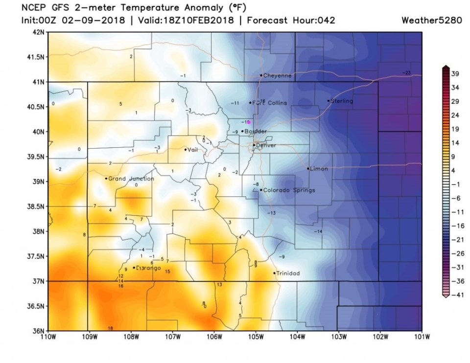
Figure 3 is the temperature departures from normal for midday Saturday.  You can see that the cold air is just deep enough to drain into the mountain valleys and passes.

Figure 1: 10 day graphical forecast from weatherunderground.com for Longmont.

Figure 2: Surface temperature departure from normal (white) - oranges and yellows are above normal for midday today. Blues are below normal. Added line is more likely western extent of cold air. From weather5280.com

Figure 3: Surface temperature departure from normal (white) - oranges and yellows are above normal for midday Saturday. Blues are below normal.From weather5280.com

The longer range forecast:

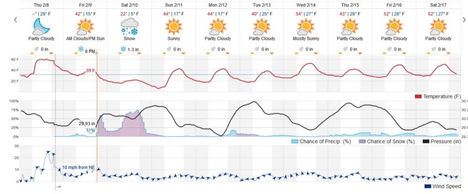
The graphical forecast from China's weather service has us cloudy through Saturday night with the greatest chance of light to moderate snow showers after 2pm on Saturday (Figure 4).

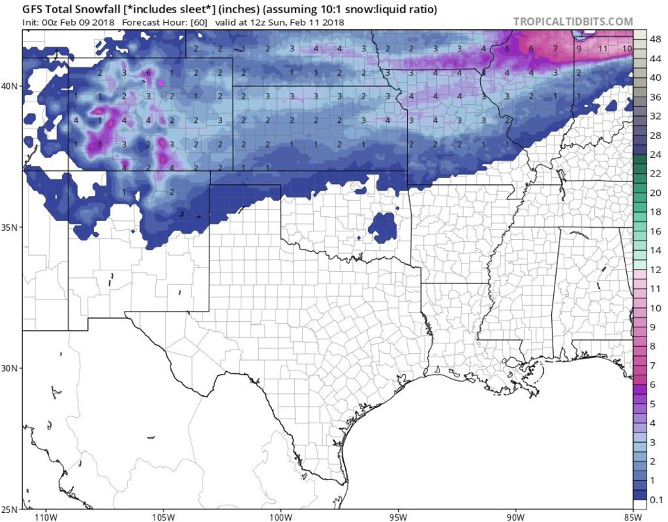
Figure 5 is the GFS take on snowfall totals.  It has us in the 1-2 inch range by Sunday morning.

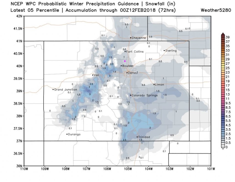
Figure 6 is the WPC 50th percentile probabilistic forecast. We are in the 1-2 inch area there by Sunday night.

Note, in Figure 1, our Tuesday-ish storm is performing the standard fade-to-nothing trick.

Figure 4: The 7! Timer Chinese model showing snow period 2pm to midnight Saturday.

Figure 5: The total snowfall between Thursday PM and Sunday morning from the GFS. From tropicaltidbits.com Longmont is the pink dot.

Figure 6: The total snowfall between Thursday PM and Sunday night from the WPC. From weather5280.com Longmont is the pink dot.

Current Weather

Light rain

Light rain

41°F

UV Index
0 Low
Pressure
29.98 Steady
Visibility
6 miles
Dewpoint
38 °F
Humidity
90%
Wind
N 2.7 mph
Gust
5.5 mph
Wind Chill
39 °F

Hourly Forecast

Today
11 PM
41°F
Rain
Tomorrow
12 AM
41°F
Rain
Tomorrow
1 AM
40°F
Rain
Tomorrow
2 AM
39°F
Rain
Tomorrow
3 AM
39°F
Rain
Tomorrow
4 AM
38°F
Cloudy
Tomorrow
5 AM
37°F
Cloudy
Tomorrow
6 AM
37°F
Cloudy
Tomorrow
7 AM
38°F
Cloudy
Tomorrow
8 AM
40°F
Cloudy
Tomorrow
9 AM
44°F
Cloudy
Tomorrow
10 AM
47°F
Mostly cloudy

7 Day Forecast

Rain and snow

Saturday

43 °F

Chilly with a mix of snow and rain; travel in the foothills and mountains will be slippery due to snow


Rain and snow

Saturday Night

37 °F

Cloudy with rain, mixed with a little snow late; travel in the foothills and mountains will be slippery due to snow


Thunderstorms

Sunday

61 °F

Mostly cloudy and warmer; a thundershower in spots in the afternoon


Partly cloudy w/ t-storms

Sunday Night

37 °F

A thunderstorm in spots in the evening; otherwise, partly cloudy


Partly sunny

Monday

71 °F

Partly sunny, pleasant and warmer


Intermittent clouds

Monday Night

42 °F

Partly cloudy


Mostly sunny

Tuesday

73 °F

Mostly sunny and pleasant


Mostly cloudy

Tuesday Night

43 °F

Mostly cloudy


Intermittent clouds

Wednesday

65 °F

Times of sun and clouds with a passing shower in the afternoon


Rain

Wednesday Night

42 °F

Mainly clear


Sunrise and Sunset

Sunrise
6:04 AM
Sunset
7:52 PM

Based on AccuWeather data