Skip to content

The Next Storm/Next Snow Forecast Discussion from the Cherrywood Observatory – January 16, 2018

This content was originally published by the Longmont Observer and is licensed under a Creative Commons license.

Forecast Discussion:

I'll update this post later in the day Tuesday with actual snowfall amounts, but it looks like I received 1.5" of snow in NE Longmont.   We'll be a bit chilly today but warmer than Monday. The front is still sitting off to our west (Figure 1) but the core of the cold air is drifting east.

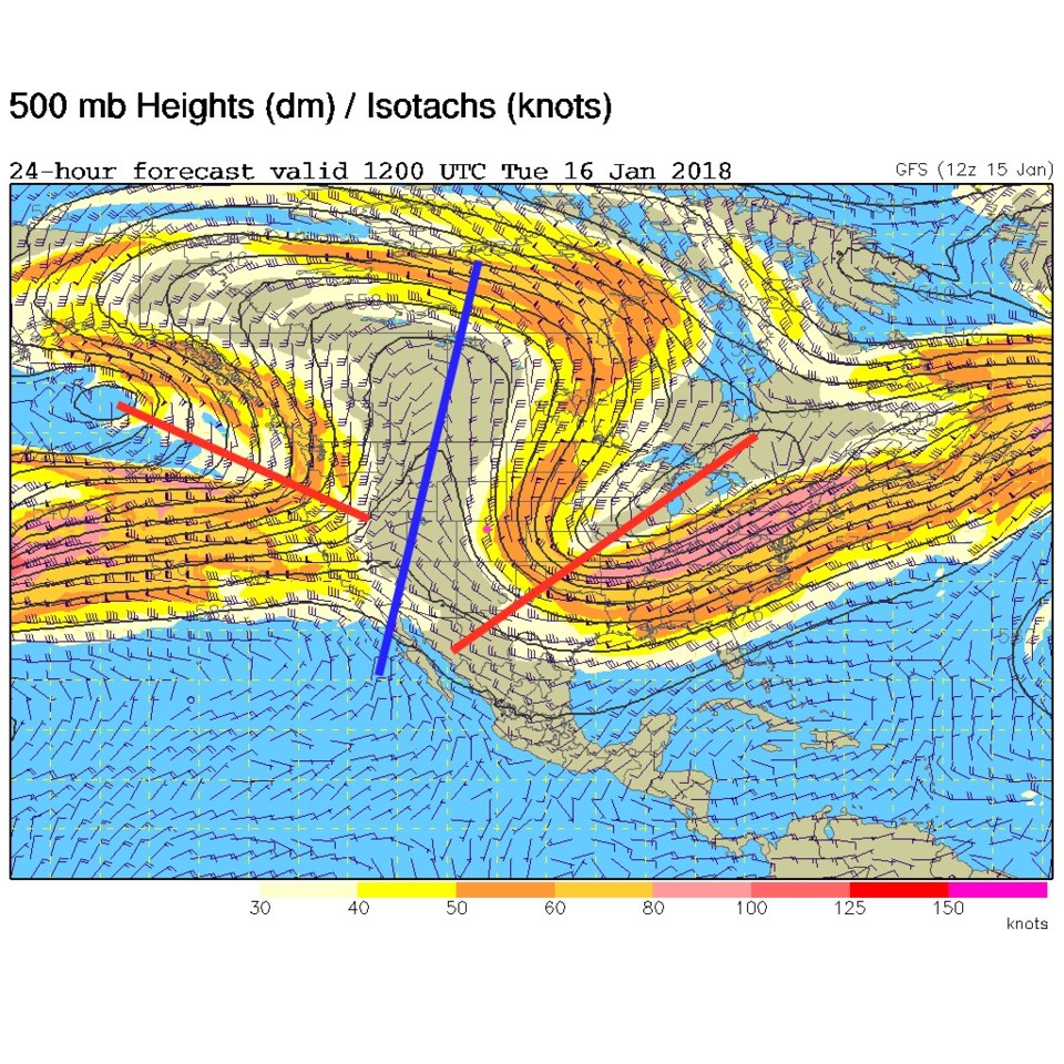
The upper level pattern this week will again be a large ridge to our west or overhead (the blue line in Figure 2). We should see 60'sF, or nearly that warm, by the end of the week.

Midday update: Longmont received just a bit over and under 1" from this last storm (following a glaze of freezing rain/ice).  See Figure 1a.

Figure 1a: CoCoRaHS snow total reports for Monday 1/15-Tuesday 1/16.

Figure 1: Surface analysis forecast map for Tuesday Midday from the NCEP.

Figure 2: The 500mb forecast upper level map for Tuesday midday from the GFS.

The longer range forecast:

Then our next storm comes in Saturday.  This pattern by then is almost the exact flip of the week ahead of it (Figure 3). A rather strong trough is moving in from the west and models are getting excited about snow (but we've seen THAT before!).

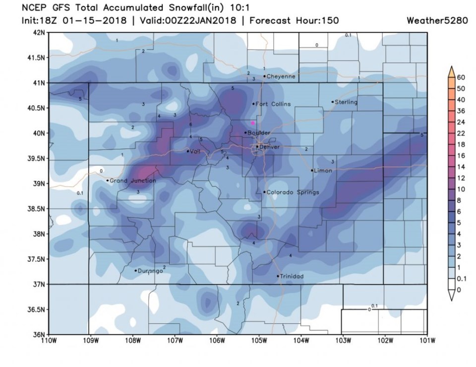
For fun, the GFS paints Longmont with 3-4" of snow by later Saturday (Figure 4).  I might invest in Bitcoin before putting money on this though.  <grin>  Enjoy the warm up in the meantime.

Figure 3: The 500mb forecast upper level map for Saturday midday from the GFS.

Figure 4: The total snowfall accumulation forecast from Monday PM to Saturday PM from weather5280.com

Current Weather

Mostly cloudy

Mostly cloudy

51°F

UV Index
2 Low
Pressure
29.99 Rising
Visibility
8 miles
Dewpoint
38 °F
Humidity
59%
Wind
W 1.1 mph
Gust
4.1 mph
Wind Chill
51 °F

Hourly Forecast

Today
9 AM
53°F
Partly sunny
Today
10 AM
58°F
Partly sunny
Today
11 AM
62°F
Partly sunny
Today
12 PM
64°F
Partly sunny
Today
1 PM
67°F
Partly sunny
Today
2 PM
68°F
Partly sunny
Today
3 PM
69°F
Partly sunny
Today
4 PM
70°F
Partly sunny
Today
5 PM
68°F
Partly sunny
Today
6 PM
67°F
Partly sunny
Today
7 PM
65°F
Partly sunny
Today
8 PM
61°F
Intermittent clouds

7 Day Forecast

Partly sunny

Monday

70 °F

Partly sunny and pleasant


Intermittent clouds

Monday Night

44 °F

Partly cloudy


Mostly sunny

Tuesday

74 °F

Mostly sunny; windy in the morning, then pleasant in the afternoon


Intermittent clouds

Tuesday Night

44 °F

Clearing


Partly sunny w/ showers

Wednesday

65 °F

Periods of clouds and sun, becoming breezy with a passing shower in the afternoon


Mostly cloudy

Wednesday Night

39 °F

A thundershower in parts of the area in the evening; otherwise, mostly cloudy


Intermittent clouds

Thursday

57 °F

Windy in the morning; cooler with intervals of clouds and sun


Mostly clear

Thursday Night

32 °F

Mainly clear


Partly sunny

Friday

68 °F

Warmer with some sun


Partly cloudy

Friday Night

33 °F

Partly cloudy


Sunrise and Sunset

Sunrise
6:02 AM
Sunset
7:54 PM

Based on AccuWeather data