Skip to content

The Next Storm/Next Snow Forecast Discussion from the Cherrywood Observatory – March 6 , 2018

This content was originally published by the Longmont Observer and is licensed under a Creative Commons license.

Forecast Discussion:

There was real wind around the Front Range with gusts reported that hit the 55-76mph range. I think I saw Rocky Flats topped 90mph yesterday. Wow. There were some destructive fires out on the Plains with homes and structures lost.  As far as I can tell, Monday PM, Longmont escaped harm.  The high wind and fire weather warnings have expired around sunset Monday.

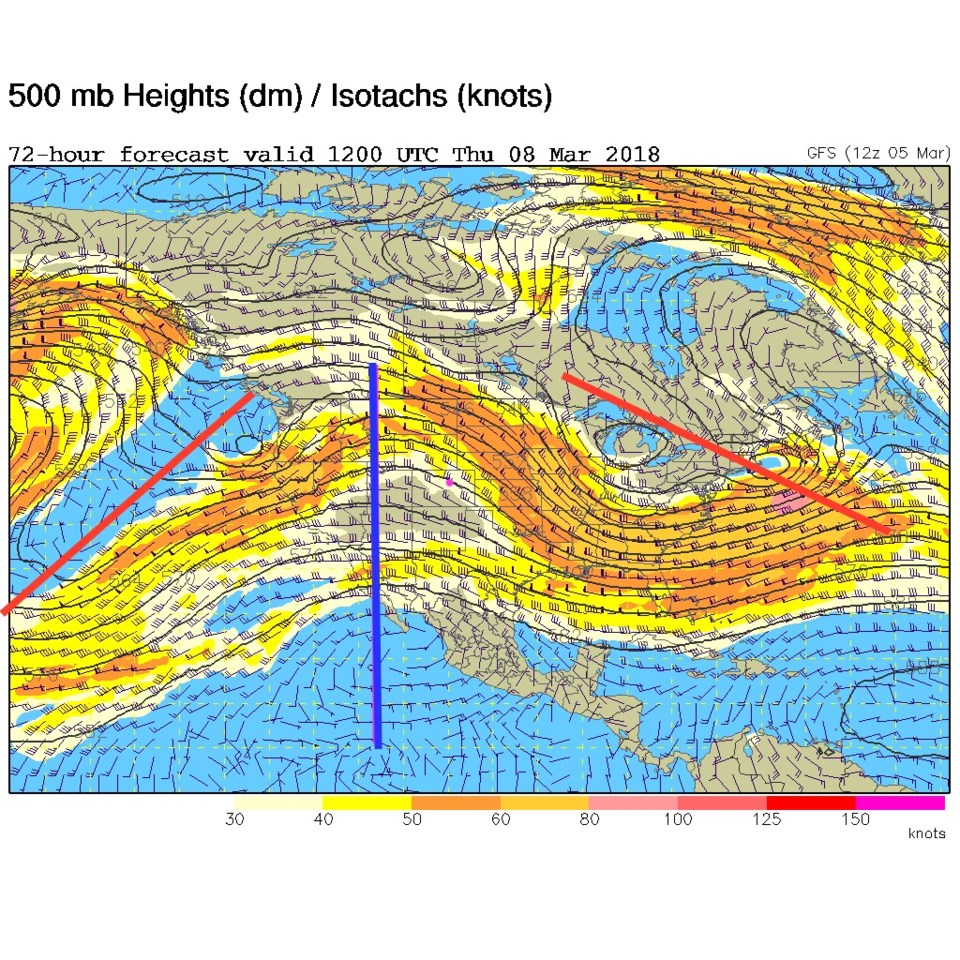
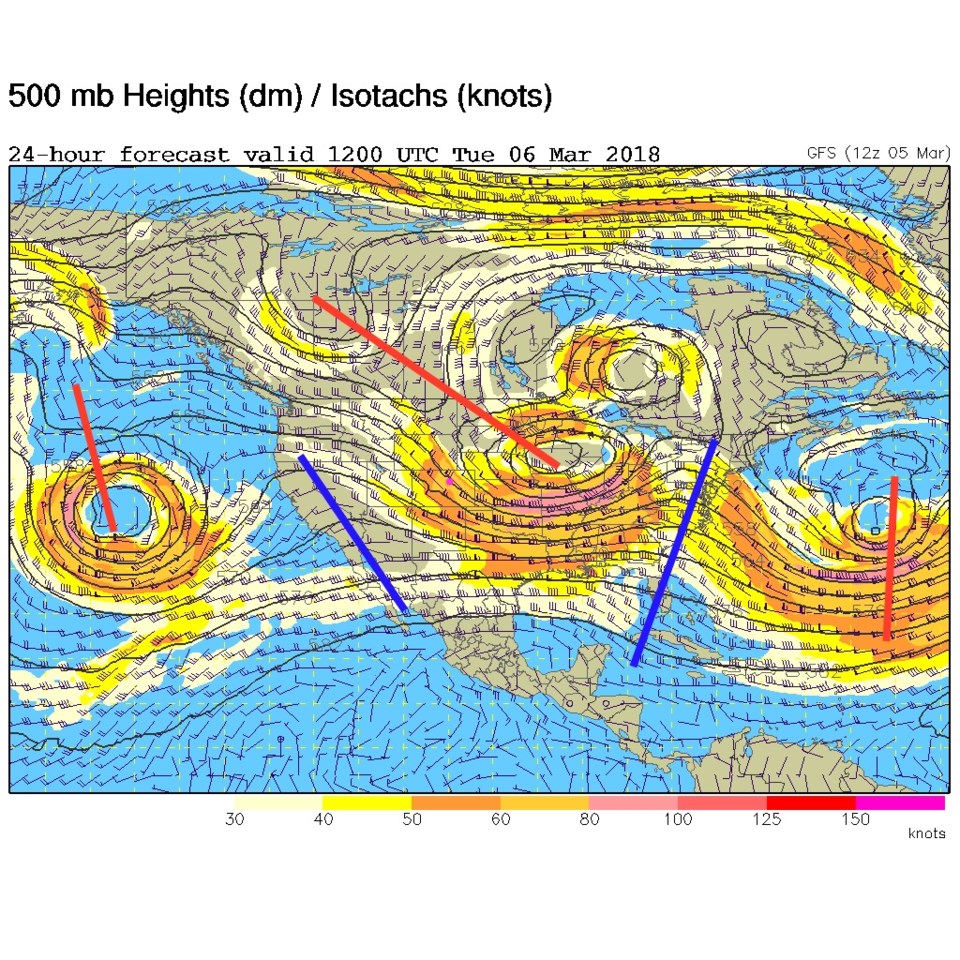
Very spring like (and dry) weather will now be the norm for the next 10 days.  Figure 1 is the upper air map for this morning (Tuesday) and the trough- that brought down the cold air and kicked up the wind- is pulling off to the northeast.  The ridge you can see (blue line) on the west coast will now become our weather reality.

Watch for temperatures to climb into the 60's and 70'sF for the next 10 days... lets see why below...

Figure 1: The 500mb upper air forecast map for Tuesday AM from the GFS. Longmont is the pink dot in all images. Troughs are red lines, ridges are blue lines.

The longer range forecast:

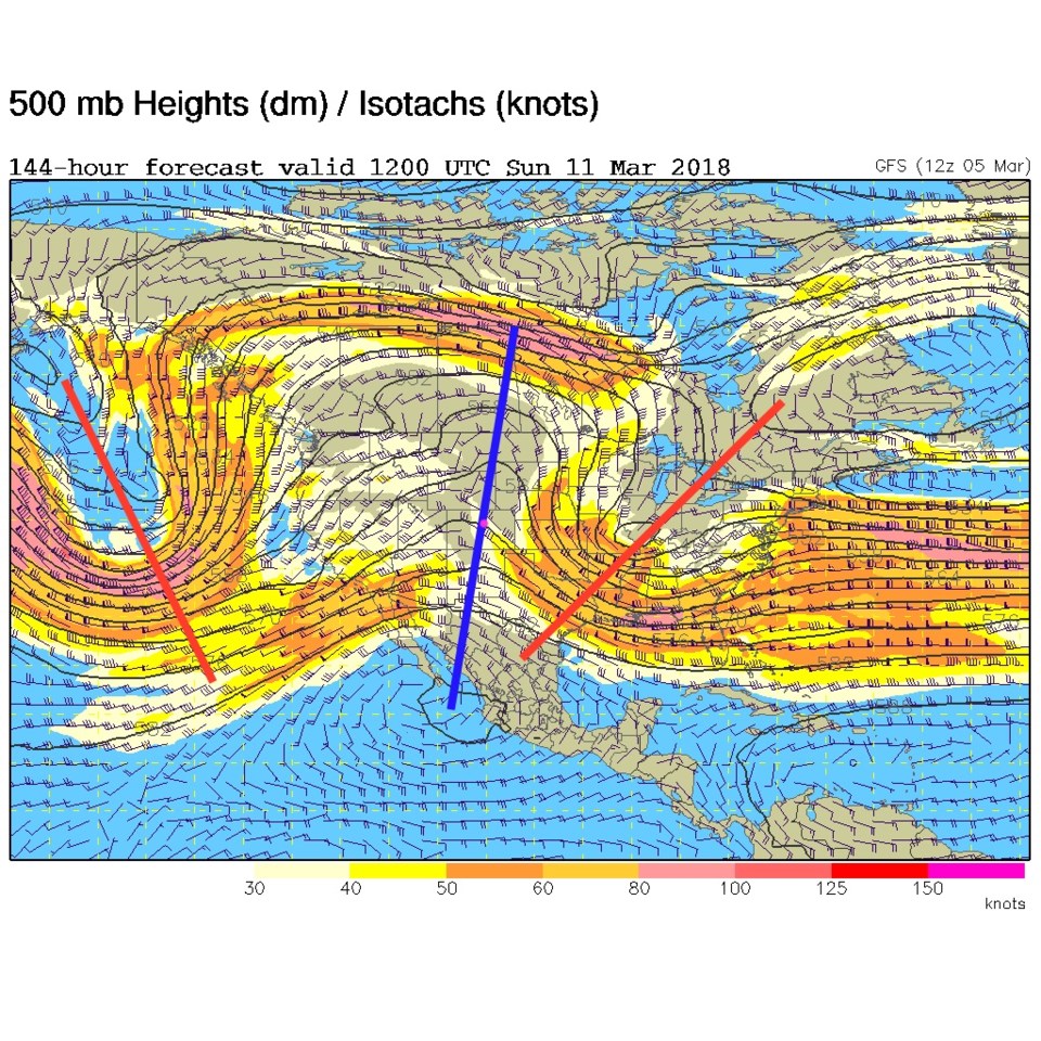
By Thursday (Figure 2) the ridge is almost overhead.  Really warm and dry conditions continue. Figure 3 is the same map for next weekend and the ridge IS on our heads (the pink dot). This 'omega' shape in the 'jet stream' tends to be very stable and not move to either the west or the east.  Uh oh.  Dry, warm weather continues.

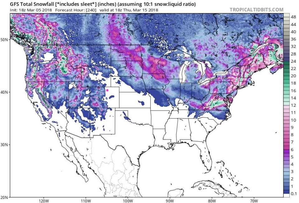
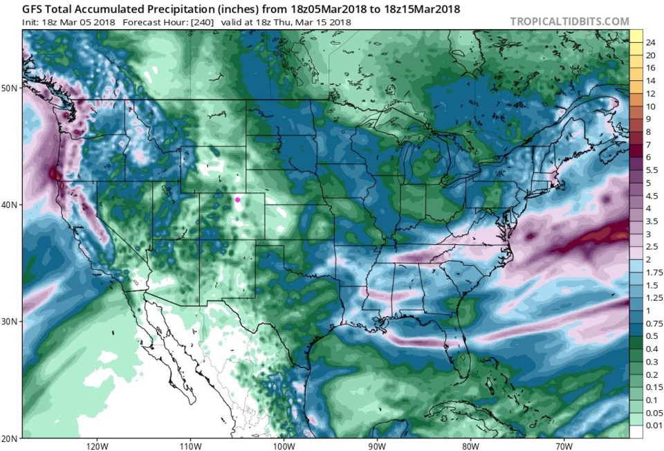
But what about precipitation?  The northwest flow as the ridge approaches will keep snow going in the mountains for another day. Figure 4 is the next 10 days of snowfall accumulation.  Western Colorado keeps getting snow, but the Longmont/pink dot is snow-less. But will it rain? Figure 5 is the same 10 days period but with liquid equivalence (snow or rain).  We are in one of the few spots in the nation that is rain-less - like Phoenix and Yuma.

Figure 2: The 500mb upper air forecast map for Thursday AM from the GFS. Longmont is the pink dot in all images. Troughs are red lines, ridges are blue lines.

Figure 3: The 500mb upper air forecast map for Sunday AM from the GFS. Longmont is the pink dot in all images. Troughs are red lines, ridges are blue lines.

Figure 4: The 10 day snowfall accumulation map from the GFS from tropical tidbits starting Monday pm 3/5.

Figure 5: The 10 day rainfall accumulation map from the GFS from tropical tidbits starting Monday pm 3/5.

Current Weather

Mostly cloudy

Mostly cloudy

51°F

UV Index
2 Low
Pressure
29.49 Rising
Visibility
8 miles
Dewpoint
22 °F
Humidity
32%
Wind
W 12.4 mph
Gust
28.6 mph
Wind Chill
51 °F

Hourly Forecast

Today
11 AM
53°F
Showers
Today
12 PM
54°F
Cloudy
Today
1 PM
55°F
Cloudy
Today
2 PM
56°F
Cloudy
Today
3 PM
57°F
Cloudy
Today
4 PM
57°F
Cloudy
Today
5 PM
56°F
Cloudy
Today
6 PM
55°F
Cloudy
Today
7 PM
55°F
Cloudy
Today
8 PM
53°F
Mostly cloudy
Today
9 PM
51°F
Intermittent clouds
Today
10 PM
49°F
Intermittent clouds

7 Day Forecast

Showers

Monday

57 °F

Winds gusting past 40 mph; a brief shower or two this morning; otherwise, cloudy and cooler


Intermittent clouds

Monday Night

41 °F

Partly cloudy


Partly sunny w/ showers

Tuesday

58 °F

A couple of showers in the morning; otherwise, windy and cool with times of clouds and sun


Partly cloudy

Tuesday Night

33 °F

Partly cloudy


Intermittent clouds

Wednesday

60 °F

Times of clouds and sun


Mostly cloudy

Wednesday Night

38 °F

Increasing clouds


Partly sunny w/ showers

Thursday

56 °F

Times of clouds and sun with a couple of showers; cool


Cloudy

Thursday Night

37 °F

Cloudy


Mostly cloudy

Friday

62 °F

Mostly cloudy and warmer


Mostly clear

Friday Night

36 °F

Mainly clear


Sunrise and Sunset

Sunrise
5:53 AM
Sunset
8:01 PM

Based on AccuWeather data