This content was originally published by the Longmont Observer and is licensed under a Creative Commons license.
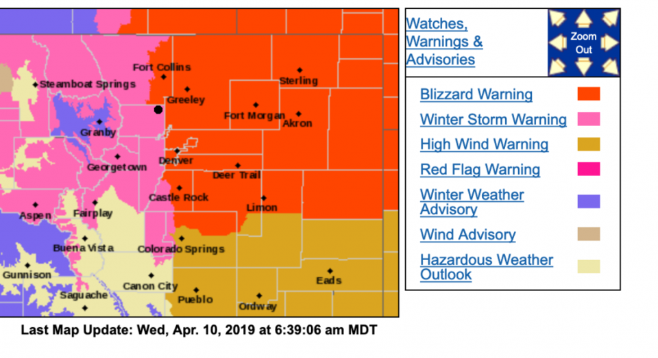
6:30am Update:
The blizzard warning has been expanded westward to include much of the I-25 corridor. The eastern parts of Longmont are now included in this warning. The western parts aren't too far away from it...
Blizzard Warning
URGENT - WINTER WEATHER MESSAGE
National Weather Service Denver CO
431 AM MDT Wed Apr 10 2019
...STRONG WINTER STORM WITH BLIZZARD CONDITIONS LATER TODAY
THROUGH THURSDAY MORNING...
(Now including FC,BE,FL,LM,eDN)
A powerful winter storm will bring heavy snow and blizzard conditions to north central and northeast Colorado today through Thursday morning. Rain and snow showers will increase this morning with widespread rain expected by noon across the Front Range. As temperatures fall, rain will change to snow early to mid afternoon
along the I-25 corridor. Conditions will deteriorate very quickly when the rain changes to snow. Roads will become snow and slush covered leading to slippery conditions this afternoon and evening. Blowing snow will reduce visibilities to near zero this afternoon and tonight. The evening commute will be very difficult if not impossible. Road closures will be possible.
Region included in the blizzard warning:
Fort Collins-Denver-Castle Rock-Briggsdale-Greeley-Fort Morgan-
Byers-Limon-Sterling-Akron-Julesburg-Holyoke-
Including the cities of Fort Collins, Hereford, Loveland, Nunn, Aurora, Brighton, City of Denver, Denver International Airport,
Highlands Ranch, Littleton, Parker, Castle Rock, Elbert, Fondis, Kiowa, Larkspur, Briggsdale, Grover, Pawnee Buttes, Raymer, Stoneham, Eaton, Fort Lupton, Greeley, Roggen, Brush, Fort Morgan, Goodrich, Wiggins, Bennett, Byers, Deer Trail, Leader, Agate, Hugo, Limon, Matheson, Crook, Merino, Sterling,
Peetz, Akron, Cope, Last Chance, Otis, Julesburg, Ovid, Sedgwick,Amherst, Haxtun, and Holyoke
431 AM MDT Wed Apr 10 2019
...BLIZZARD WARNING REMAINS IN EFFECT FROM NOON TODAY TO NOON MDT THURSDAY...
* WHAT...Blizzard conditions expected. Total snow accumulations of 5 to 10 inches expected. Winds gusting as high as 65 mph.
* WHERE...Portions of east central, north central and northeast Colorado.
* WHEN...From noon today to noon MDT Thursday.
* ADDITIONAL DETAILS...Travel is expected to become very difficult to impossible. Widespread blowing snow could significantly reduce visibility. The hazardous conditions will impact the commute for this evening and Thursday morning. Strong winds and heavy snow could cause tree damage.
PRECAUTIONARY/PREPAREDNESS ACTIONS...
A Blizzard Warning means severe winter weather conditions are expected or occurring. Falling and blowing snow with strong winds and poor visibilities are likely. This will lead to whiteout conditions, making travel extremely dangerous. Do not travel. If you must travel, have a winter survival kit with you. If you get stranded, stay with your vehicle.
The latest road conditions for the state you are calling from can be obtained by calling 5 1 1.
End 6:30am update.
Forecast Discussion:
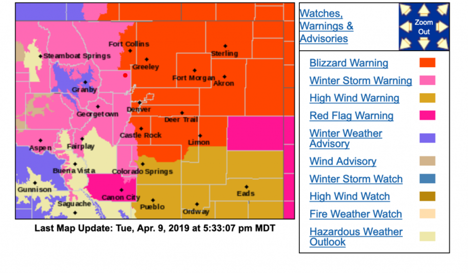
URGENT - WINTER WEATHER MESSAGE National Weather Service Denver CO 1147 AM MDT Tue Apr 9 2019 ...
STRONG WINTER STORM EXPECTED TO MOVE IN WEDNESDAY... .Very warm
temperatures are expected today, ahead of a developing upper level
storm system moving over the Great Basin. Drastic changes in the
weather are expected to occur on Wednesday as a strong cold front
will race across northeast Colorado which will bring much colder
temperatures, strong north winds and heavy snow. Areas of heavy
snowfall across the Front Range to the far eastern plains and strong
winds will result in poor visibility and difficult driving
conditions. Temperatures plummeting will result in icy roads.
Residents of northeast Colorado should begin making preparations for
this developing storm to avoid being caught by harsh winter
conditions.

Boulder and the western suburbs of Denver- Including the cities of
Arvada, Boulder, Golden, Lakewood, and Longmont
Issued 1147 AM MDT Tue Apr 9 2019 ...
WINTER STORM WARNING IN EFFECT FROM NOON WEDNESDAY TO NOON MDT THURSDAY...
* WHAT...Heavy snow expected. Total snow accumulations of 3 to 5
inches expected. Winds gusting as high as 40 mph.
* WHERE...Boulder and the western suburbs of Denver.
* WHEN...From noon Wednesday to noon MDT Thursday.
* ADDITIONAL DETAILS...Plan on slippery road conditions. The
hazardous conditions will impact the evening commute.

PRECAUTIONARY/PREPAREDNESS ACTIONS... A Winter Storm Warning for
snow means severe winter weather conditions will make travel very
hazardous or impossible. If you must travel, keep an extra flashlight, food and water in your vehicle in case of an emergency.
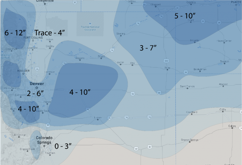
The discussion explaining the big picture set up is in yesterday's post. Today, we're concerned with the above warning, the blizzard warning out on the Plains (Figure 1, above), and the model snowfall round-up:
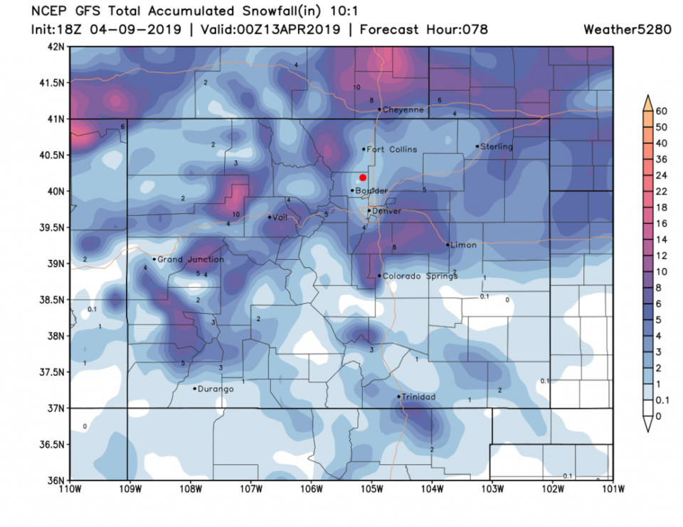
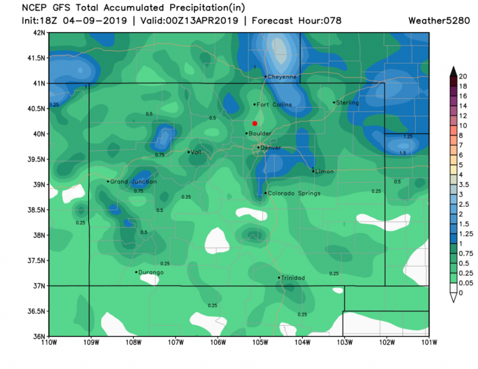
We see the GFS giving us 1-3 inches (the down slope snow-hole is in effect again - Figure 2). This model gives us 0.25-0.3 inch of water (Figure 3).
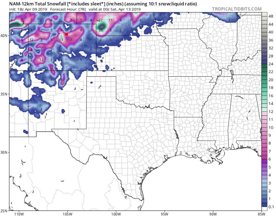
The NAM gives us 5-7 inches of snow - we do NOT have model agreement yet (Figure 4).
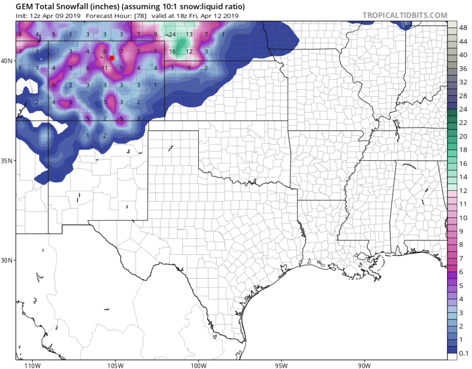
The GEM has the down slope notch and backs us off to 2-4 inches of snow (Figure 5).
The forecasters at weather5280.com are giving us a Trace to 4 inches (wind driven snow and down slope uncertainties working together - Figure 6).
The longer range forecast:
We remain cool with showers at times over the next few days. More on that after this storm does-its-thing.