Skip to content

Next Storm/Next Snow Forecast Discussion from the Cherrywood Observatory – April 13-14, 2019

This content was originally published by the Longmont Observer and is licensed under a Creative Commons license.

Forecast Discussion:

I'll post early since the showers are ongoing this afternoon, and will continue through the night Friday into Saturday and on into the afternoon. I'm still dealing with spotty internets in St. Louis where an inch of rain is scheduled for tomorrow.

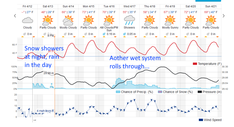
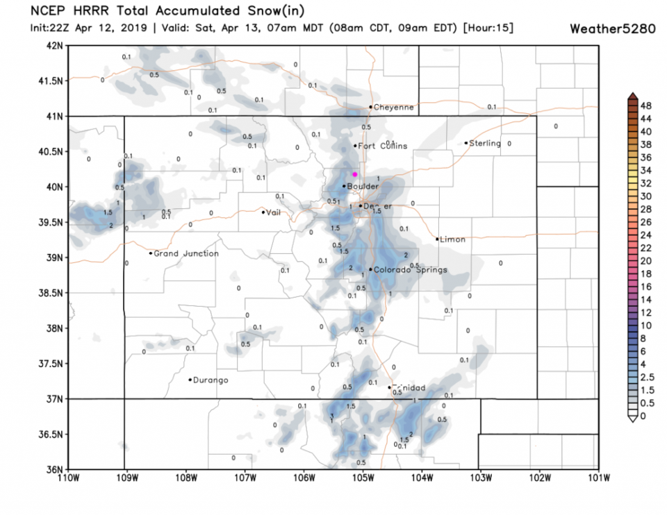
This weekend's storm system is digging south of the state, basically throwing some moisture around the top of the Low up-slope into the Front Range (Figure 1). Our daytime rain, nighttime snow showers will continue through 8pm Saturday (Figure 2).

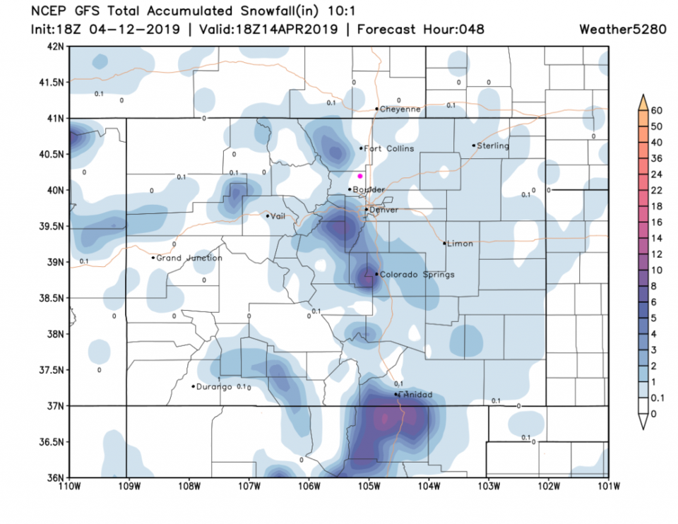
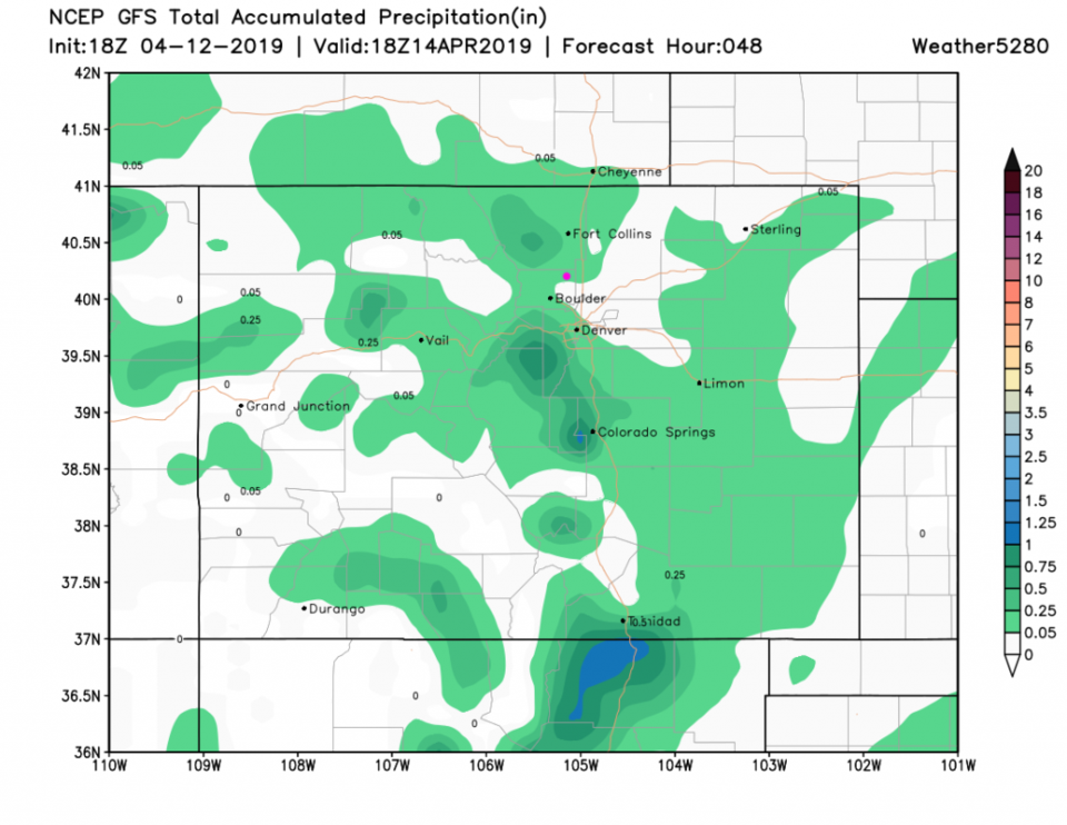
Through 7am, the HRRR actually gives us 1/2 inch to 1 inch of snow in places (Figure 3). The GFS (a less precise resolution) puts minimal snow around the area but not in town (Figure 4). For precipitation (water content) it is minimal as well (Figure 5).

The longer range forecast:

Our next low moves in Tuesday through Thursday bringing more rain (Figure 2). At least we return to the upper 60'sF and mid 70'sF after this system moves off later Saturday night.

Figure 1: The forecast surface map for Fridaay PM from NCEP.
Figure 2: the graphical forecast for the next 10 days for Longmont, CO from weatherunderground.com
Figure 3: the HRRR snowfall prediction up to 7am Saturday from weather5280.com
Figure 4: the forecast accumulated snowfall map from the GFS and weather5280.com for Colorado, over the next 2 days.
Figure 5: the forecast accumulated precipitation/water content map from the GFS and weather5280.com for Colorado, over the next 2 days.

Current Weather

Sunny

Sunny

68°F

UV Index
0 Low
Pressure
29.49 Falling
Visibility
8 miles
Dewpoint
42 °F
Humidity
39%
Wind
S 4.8 mph
Gust
10.5 mph
Wind Chill
68 °F

Hourly Forecast

Today
8 PM
65°F
Intermittent clouds
Today
9 PM
62°F
Cloudy
Today
10 PM
60°F
Mostly cloudy
Today
11 PM
59°F
Intermittent clouds
Tomorrow
12 AM
57°F
Intermittent clouds
Tomorrow
1 AM
55°F
Intermittent clouds
Tomorrow
2 AM
54°F
Mostly cloudy
Tomorrow
3 AM
53°F
Cloudy
Tomorrow
4 AM
51°F
Cloudy
Tomorrow
5 AM
50°F
Cloudy
Tomorrow
6 AM
49°F
Cloudy
Tomorrow
7 AM
47°F
Cloudy

7 Day Forecast

Intermittent clouds

Sunday

76 °F

Warmer with intervals of clouds and sunshine


Windy

Sunday Night

47 °F

Winds becoming strong; cloudy most of the time


Windy

Monday

56 °F

Winds gusting past 40 mph; cloudy and cooler


Intermittent clouds

Monday Night

42 °F

Partly cloudy


Partly sunny w/ showers

Tuesday

59 °F

A couple of showers in the morning; otherwise, windy and cool with times of clouds and sun


Partly cloudy

Tuesday Night

32 °F

Partly cloudy


Intermittent clouds

Wednesday

58 °F

Cool with times of clouds and sun


Intermittent clouds

Wednesday Night

38 °F

Partly cloudy


Intermittent clouds

Thursday

56 °F

Breezy and cool with sun and clouds


Intermittent clouds

Thursday Night

39 °F

Partly cloudy


Sunrise and Sunset

Sunrise
5:54 AM
Sunset
8:00 PM

Based on AccuWeather data