Skip to content

Next Storm/Next Snow Forecast Discussion from the Cherrywood Observatory – April 18, 2019

This content was originally published by the Longmont Observer and is licensed under a Creative Commons license.

Forecast Discussion:

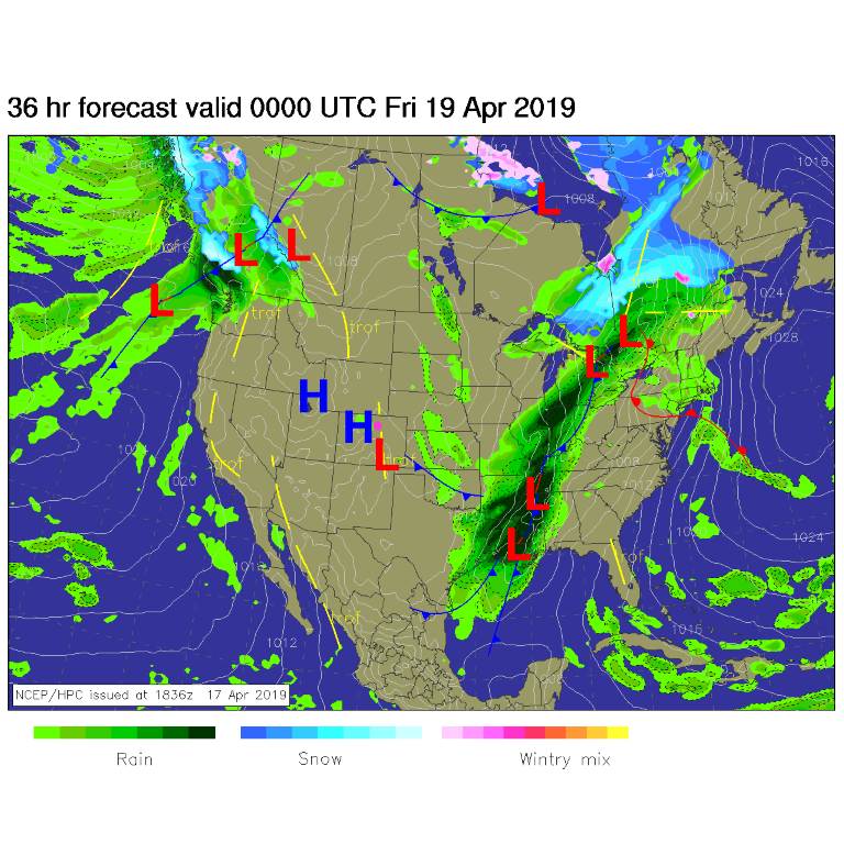
We had a nice splash of rainfall midday Wednesday from a convective cell that slid off the mountains and dissipated not long after it got the ground wet around town. We are high and dry today (Thursday) with a warm up beginning (Figure 1).

The longer range forecast:

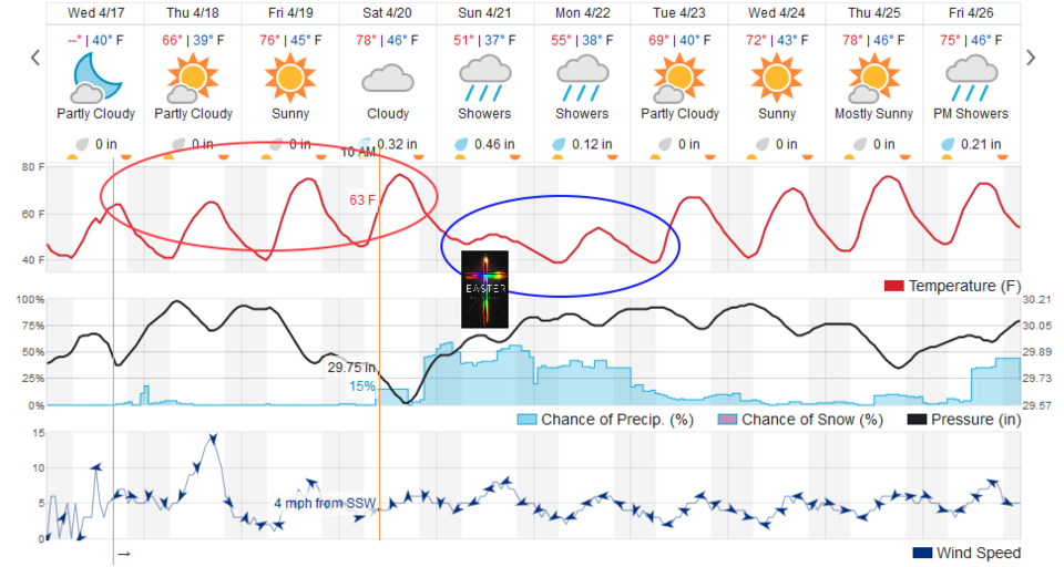
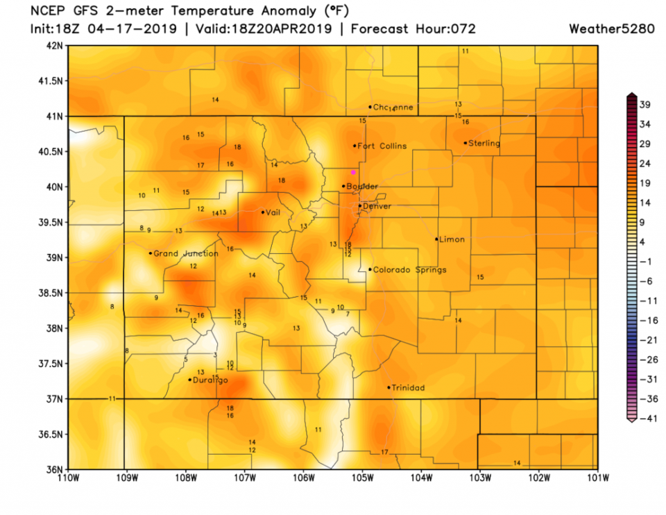
That warm up is shown in the red oval in Figure 2. We are almost up to 80°F by Saturday. Figure 3 shows the entire state, Saturday, is a bit above normal up to 20°F above normal. Unfortunately, a big wet storm system is moving in later on Saturday. We also cool down to just a bit below normal (Figure 2, blue oval).

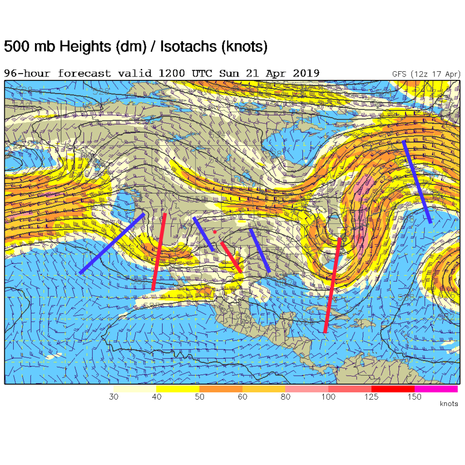
The weatherunderground.com model gives us 1/3rd an inch of water Saturday evening (Figure 2). The storm is largely north of the state Sunday morning (Figure 4) with a rather complex couple of short waves around the state (Figure 5) in the jet stream flow aloft.

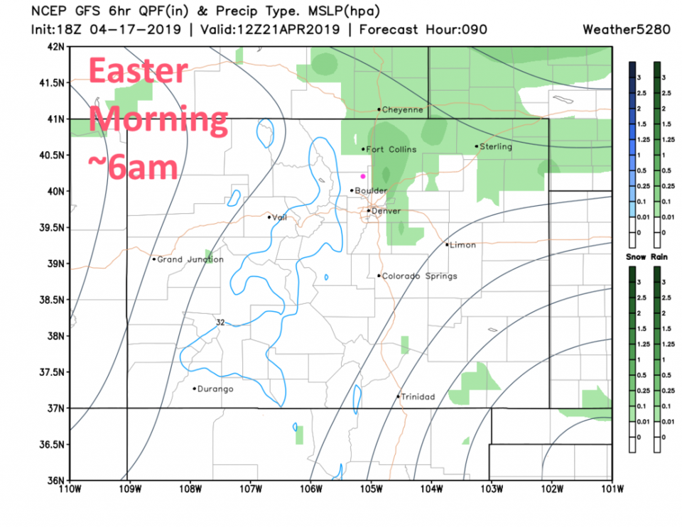
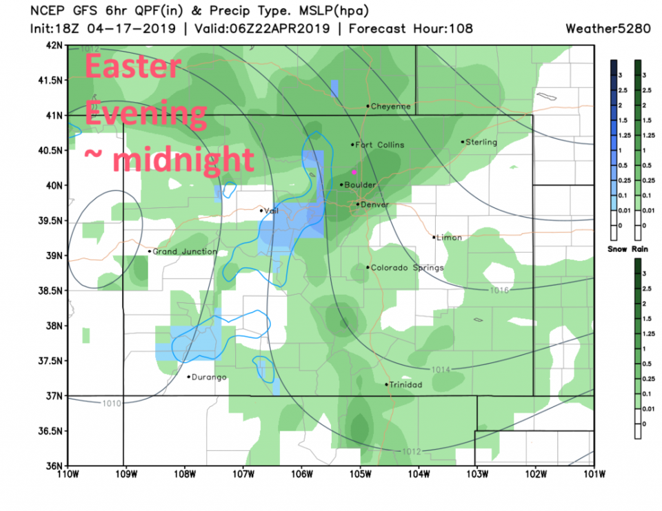
Sunday morning (outdoors sunrise services); up-slope flow will be starting and rain showers will be increasing in coverage and intensity (Figure 6). The main precipitation event kicks in later on Sunday overnight and into Monday (Figure 7). Temperatures at sunrise Sunday will be around 46°F.

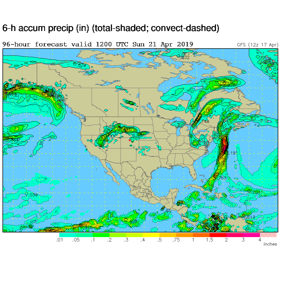
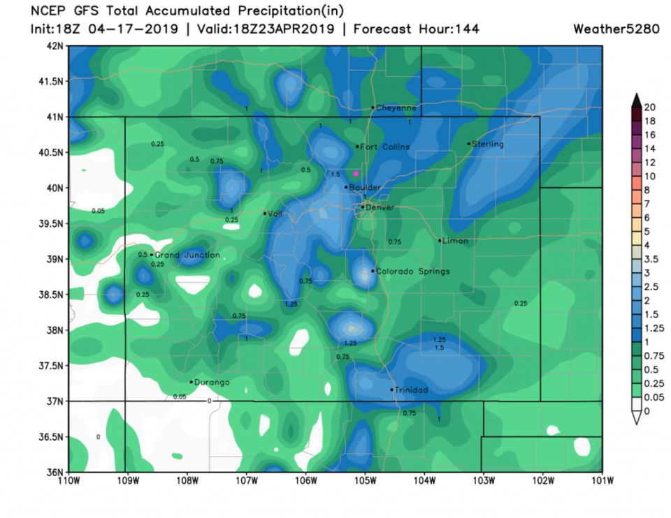
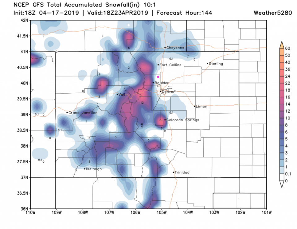
The total rainfall Saturday PM through Tuesday AM may be as high as 0.75 to 1 inch (according to the GFS at this time - Figure 8). Snowfall will be healthy for the mountains but should miss Longmont with the temperatures being too warm (Figure 9).

Figure 1: The forecast surface map for Thursday PM from NCEP.
Figure 2: the graphical forecast for the next 10 days for Longmont, CO from weatherunderground.com
Figure 3: The forecast temperature departure from normal map from the GFS and weather5280.com for Colorado, Saturday noon.
Figure 4: The surface forecast analysis for Sunday morning. Shades of green are precipitation intensity.
Figure 5: The 500mb forecast upper air analysis for Sunday morning. Pink dot is Longmont. Red lines are troughs, blue lines are ridges.
Figure 6: Snapshot of weather conditions and surface pressures over 6 hours ending Sunday 6am from the GFS and weather5280.com
Figure 7: Snapshot of weather conditions and surface pressures over 6 hours ending Sunday night midnight from the GFS and weather5280.com
Figure 8: the forecast accumulated precipitation map from the GFS and weather5280.com for Colorado, through Tuesday noon.
Figure 9: the forecast accumulated snowfall map from the GFS and weather5280.com for Colorado, through Tuesday noon.

Current Weather

Light rain

Light rain

43°F

UV Index
0 Low
Pressure
29.91 Steady
Visibility
7 miles
Dewpoint
40 °F
Humidity
90%
Wind
N 4 mph
Gust
8 mph
Wind Chill
41 °F

Hourly Forecast

Today
6 PM
42°F
Rain and snow
Today
7 PM
41°F
Rain and snow
Today
8 PM
42°F
Rain
Today
9 PM
42°F
Showers
Today
10 PM
41°F
Rain
Today
11 PM
41°F
Rain
Tomorrow
12 AM
41°F
Rain
Tomorrow
1 AM
40°F
Rain
Tomorrow
2 AM
39°F
Rain
Tomorrow
3 AM
39°F
Rain
Tomorrow
4 AM
38°F
Cloudy
Tomorrow
5 AM
37°F
Cloudy

7 Day Forecast

Rain and snow

Saturday

42 °F

Chilly with a mix of snow and rain; travel in the foothills and mountains will be slippery due to snow


Rain and snow

Saturday Night

37 °F

Cloudy with rain, mixed with a little snow late; travel in the foothills and mountains will be slippery due to snow


Thunderstorms

Sunday

61 °F

Mostly cloudy and warmer; a thundershower in spots in the afternoon


Partly cloudy w/ t-storms

Sunday Night

37 °F

A thunderstorm in spots in the evening; otherwise, partly cloudy


Partly sunny

Monday

71 °F

Partly sunny, pleasant and warmer


Intermittent clouds

Monday Night

42 °F

Partly cloudy


Mostly sunny

Tuesday

73 °F

Mostly sunny and pleasant


Mostly cloudy

Tuesday Night

43 °F

Mostly cloudy


Intermittent clouds

Wednesday

65 °F

Times of sun and clouds with a passing shower in the afternoon


Rain

Wednesday Night

42 °F

Mainly clear


Sunrise and Sunset

Sunrise
6:04 AM
Sunset
7:52 PM

Based on AccuWeather data