Skip to content

Next Storm/Next Snow Forecast Discussion from the Cherrywood Observatory – April 19, 2019

This content was originally published by the Longmont Observer and is licensed under a Creative Commons license.

Forecast Discussion:

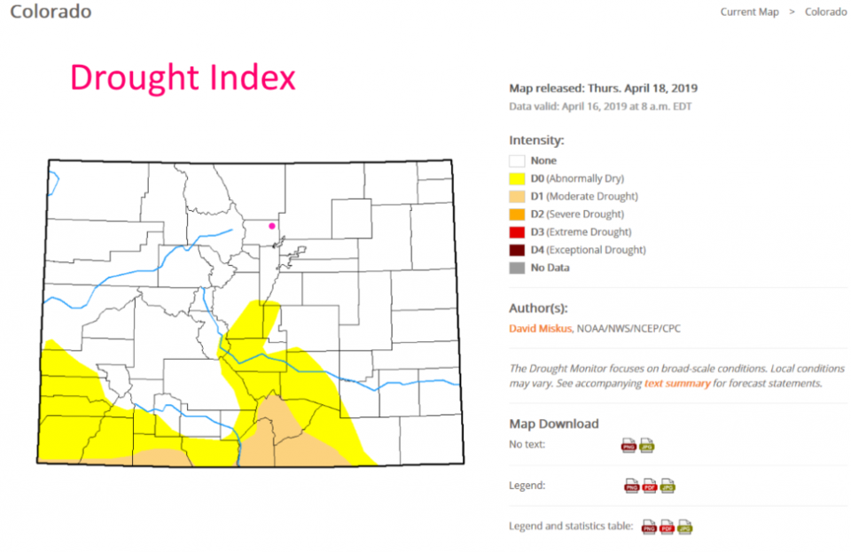
Before we look at - what is shaping up to be the first great soaking storm of the Spring - let's look at our state's state of dryness. Figure 1 is the freshly released Colorado state drought index. We have only a little bit of the two least severe drought levels down in the southern counties. We, like much of the nation, are remarkably drought free. And here comes more water.

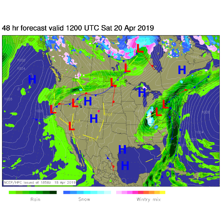
But not today - we have warming temperatures and dry air under a high pressure system (Figure 2) and a ridge aloft (not shown). It'll be windy at times, but nothing terrible. We should break 80F Saturday with very small precipitation chances.

The longer range forecast:

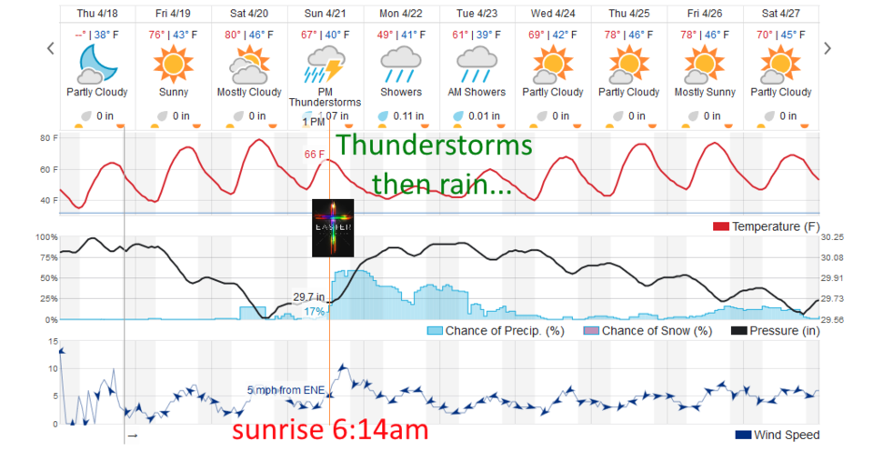
First, the Easter Forecast: It looks like the rain holds off until around 1 or 2pm. The sunrise, at 6:14am, should see about 50% cloud cover and temperatures around 47F (not horribly cold). There is a minimal chance of a shower that early in the day.

The storm moves in around 1pm- ish (I'm glad I'm cooking Easter dinner inside this year!). The weatherunderground.com model (Figure 3) gives us about 1.25 inches of water between this time and Tuesday morning.

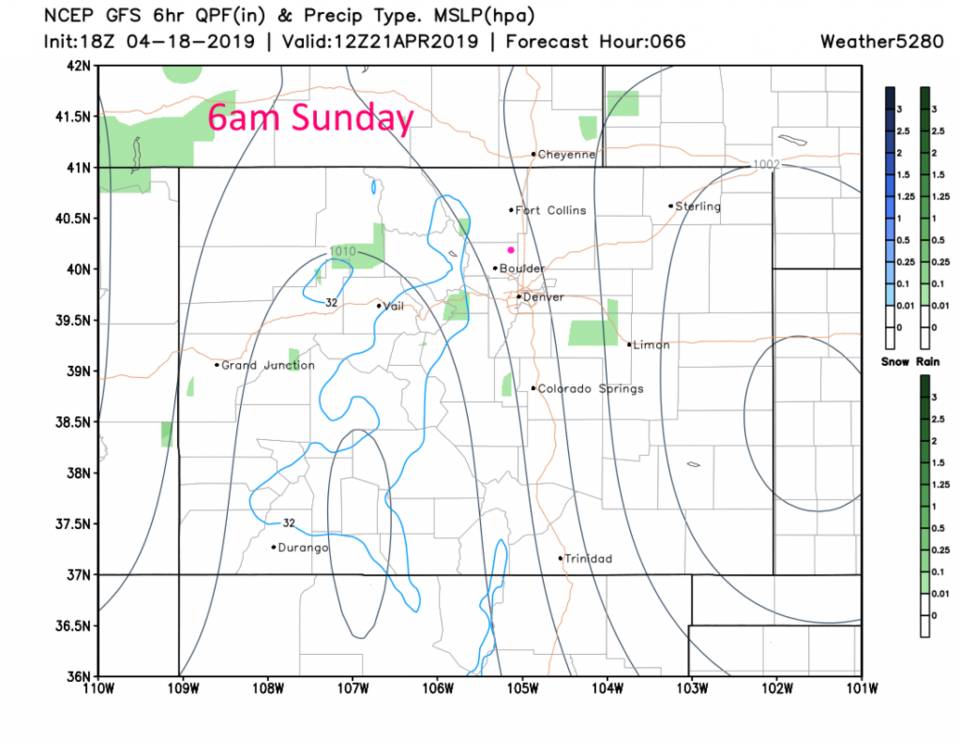
I'm going to page through the storm 6-hour-periods at a time. Figure 4, sunrise Easter morning, there is a bit of a high over the southern Rockies, still, and a weak low on the Kansas border. Things are mostly dry.
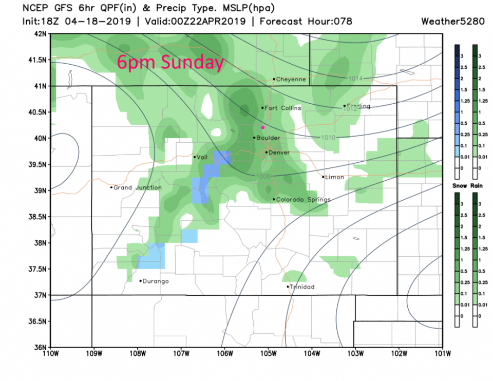
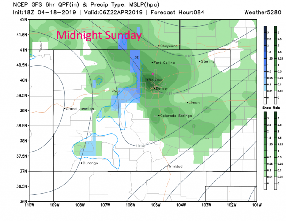
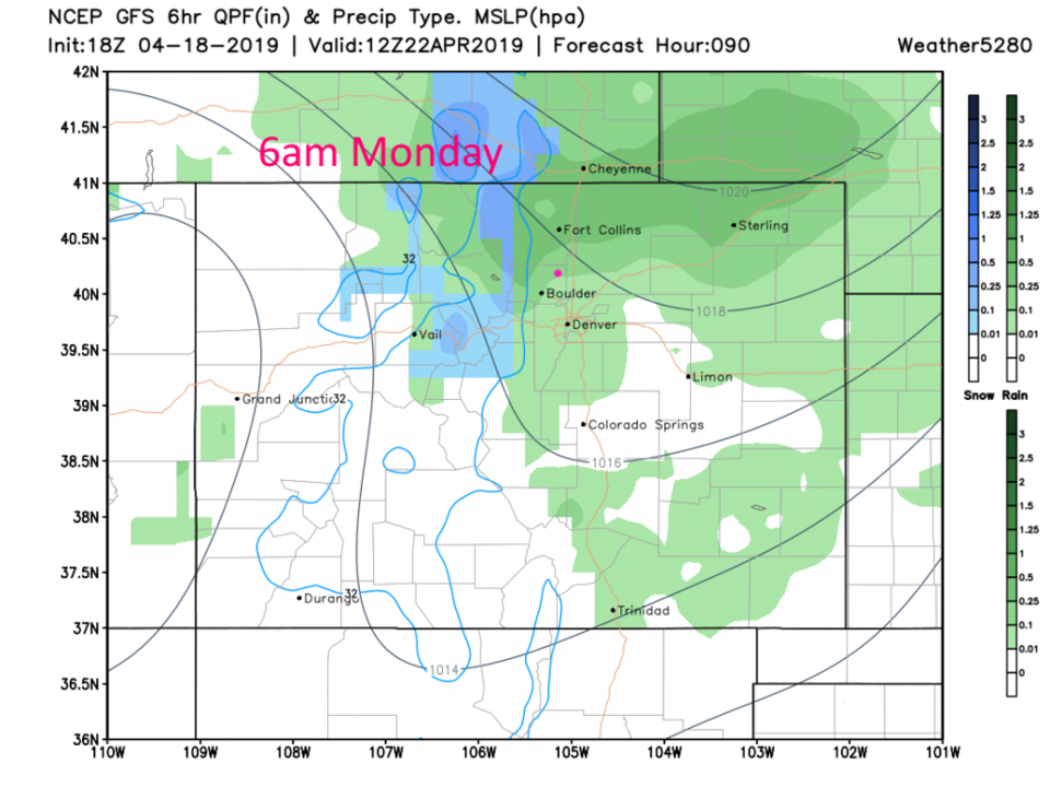
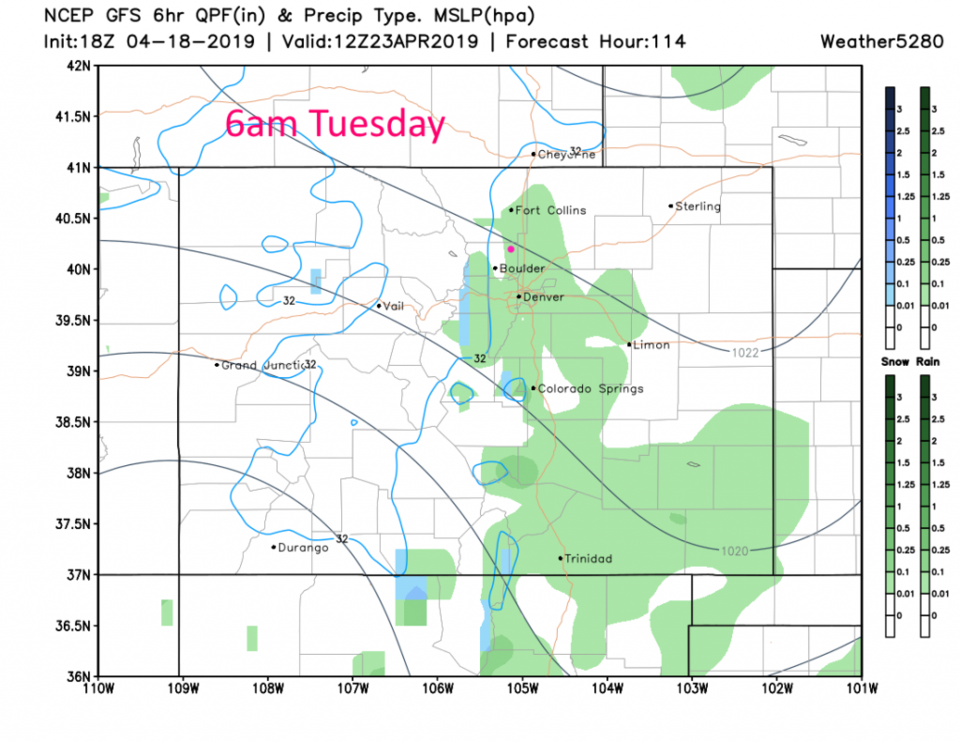
By 6pm Sunday, Figure 5, a trough has begun to dig along the Front Range. Up slope flow begins to intensify and the rain is underway (it looks like it forms quite suddenly after lunch (Figure 3)). By midnight Sunday there are some snows in the mountains but pretty heavy rain is falling around the Denver to Boulder to Loveland area (Figure 6). It is still raining some in northern Colorado Monday morning (Figure 7) continuing through the rest of the day, off and on. Rain chances finally tapers off Tuesday morning (Figure 8).

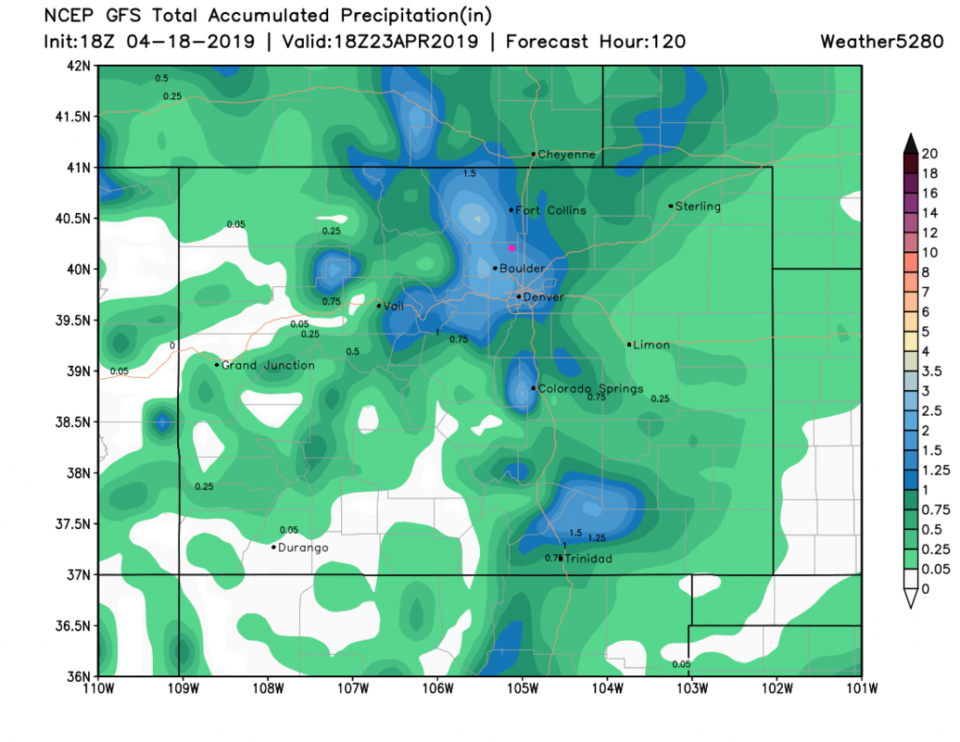
For precipitation totals (GFS only so far in these discussions):
Figure 9 gives us 1.5 inches of water.
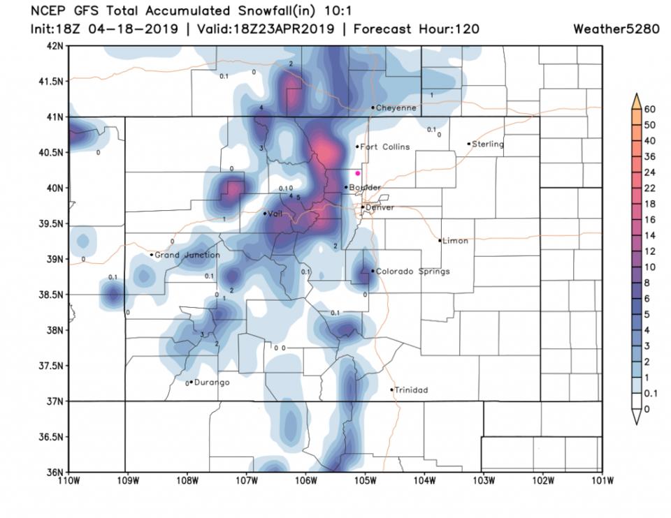
For snowfall - Figure 10 keeps it up in the foothills and mountains. It looks like the higher elevations pick up another foot. Enjoy Spring!

Figure 1: the Colorado drought index for mid-April 2019. From the USDA NOAA and the National Drought Mitigation Center.
Figure 2: The forecast surface map for Saturday AM from NCEP.
Figure 3: the graphical forecast for the next 10 days for Longmont, CO from weatherunderground.com
Figure 4: Snapshot of weather conditions and surface pressures over 6 hours ending Sunday 6am from the GFS and weather5280.com
Figure 5: Snapshot of weather conditions and surface pressures over 6 hours ending Sunday 6pm from the GFS and weather5280.com
Figure 6: Snapshot of weather conditions and surface pressures over 6 hours ending Sunday midnight from the GFS and weather5280.com
Figure 7: Snapshot of weather conditions and surface pressures over 6 hours ending Monday 6am from the GFS and weather5280.com
Figure 8: Snapshot of weather conditions and surface pressures over 6 hours ending Tuesday 6am from the GFS and weather5280.com
Figure 9: the forecast accumulated precipitation map from the GFS and weather5280.com for Colorado, through Tuesday night.
Figure 10: the forecast accumulated snowfall map from the GFS and weather5280.com for Colorado, through Tuesday night.

Current Weather

Sunny

Sunny

45°F

UV Index
3 Moderate
Pressure
30.02 Steady
Visibility
8 miles
Dewpoint
24 °F
Humidity
43%
Wind
SSE 3.8 mph
Gust
8.4 mph
Wind Chill
43 °F

Hourly Forecast

Today
9 AM
47°F
Sunny
Today
10 AM
51°F
Mostly sunny
Today
11 AM
55°F
Mostly sunny
Today
12 PM
58°F
Mostly sunny
Today
1 PM
60°F
Partly sunny
Today
2 PM
62°F
Intermittent clouds
Today
3 PM
63°F
Mostly cloudy
Today
4 PM
65°F
Mostly cloudy
Today
5 PM
63°F
Cloudy
Today
6 PM
62°F
Cloudy
Today
7 PM
59°F
Mostly cloudy
Today
8 PM
56°F
Mostly cloudy

7 Day Forecast

Mostly cloudy

Thursday

65 °F

Becoming cloudy


Mostly cloudy

Thursday Night

36 °F

Mostly cloudy


Partly sunny

Friday

70 °F

Partial sunshine


Partly cloudy

Friday Night

38 °F

Partly cloudy


Partly sunny

Saturday

66 °F

Partial sunshine


Mostly clear

Saturday Night

41 °F

Clear to partly cloudy


Mostly cloudy

Sunday

76 °F

Rather cloudy; breezy in the afternoon


Intermittent clouds

Sunday Night

43 °F

Partly cloudy


Cloudy

Monday

60 °F

Cloudy and cooler with a shower in spots; windy in the afternoon


Mostly cloudy

Monday Night

43 °F

Breezy in the evening; otherwise, mostly cloudy


Sunrise and Sunset

Sunrise
5:58 AM
Sunset
7:57 PM

Based on AccuWeather data