Skip to content

Next Storm/Next Snow Forecast Discussion from the Cherrywood Observatory – April 26, 2019

This content was originally published by the Longmont Observer and is licensed under a Creative Commons license.

In Brief:

Mild temperatures remain through Sunday with afternoon thundershower chances moving off the mountains. Cooler weather, rain, and even snow chances return early next week.

Forecast Discussion:

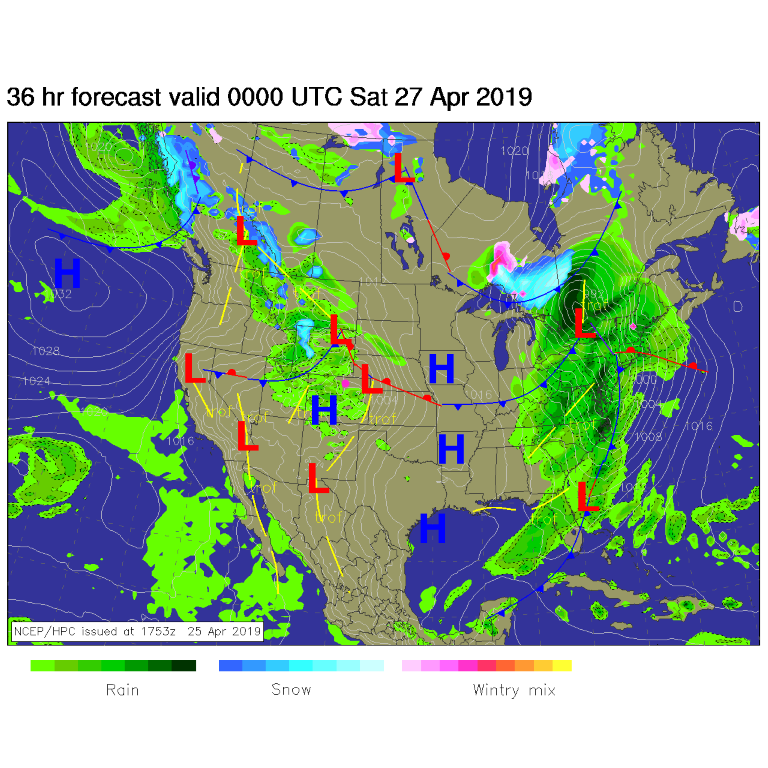
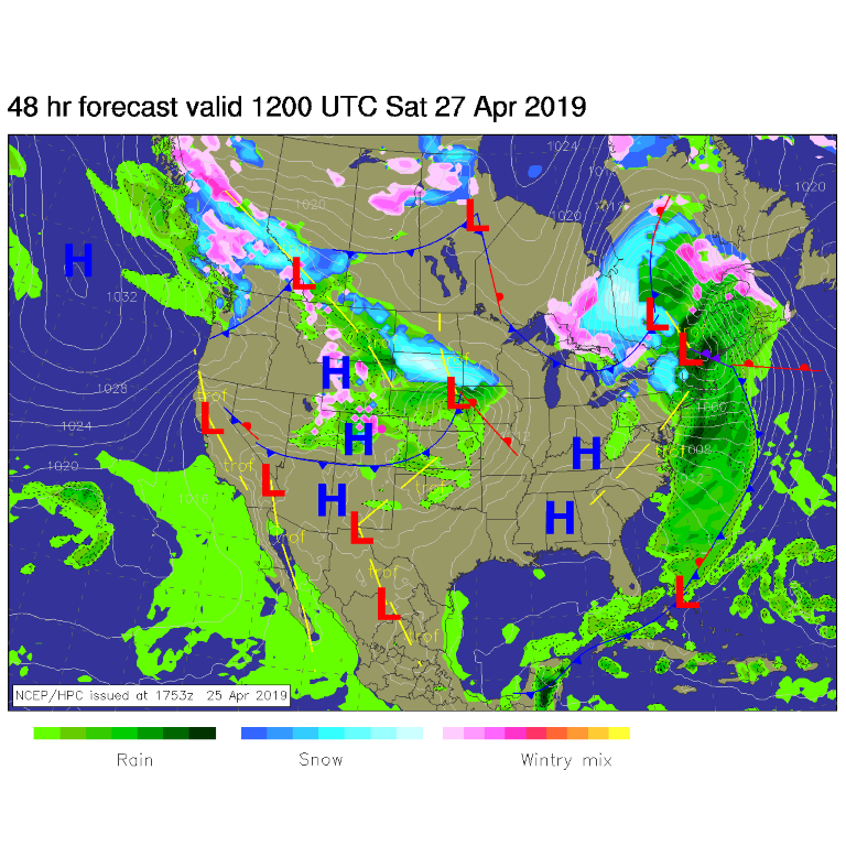
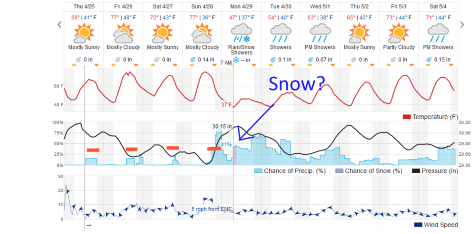
Another mild cool front is approaching the state and tapping into some more of the southern jet stream moisture. For Friday afternoon, the front is not here yet, but cool air aloft plus daytime heating will kick off mountain showers. Some of these may move out on the plains in the afternoon when daytime heating is at a maximum (Figure 1). I colored the afternoon 'warm' time with red dashes for a few days in Figure 4. You can see the chances of showers pop up at those times. The front is south of the state Saturday cooling us a bit (Figure 2) (about 5 degrees - Figure 4). Remember, lighting, even from small non-severe storms, is deadly. Respect the bolt.

The Longer Range Forecast:

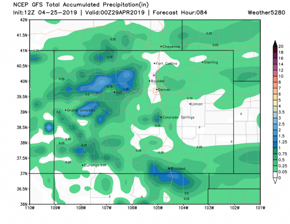
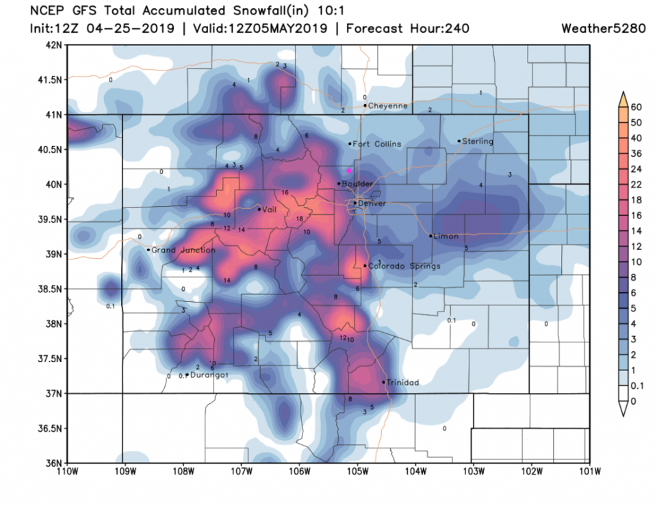
Afternoon shower chances and nice weather is the pattern through Sunday. The GFS gives most the state at least measurable rainfall through Sunday, but it is not a lot of water except for the northern and central mountains (Figure 5). The GFS keeps Longmont mostly dry to dry through the weekend.

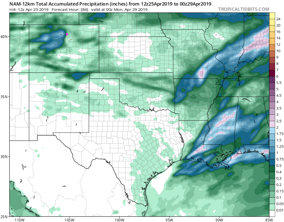
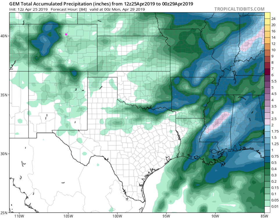
The NAM gives Longmont about 0.1 to 0.2 inch of rain through Sunday afternoon. The GEM gives us 0.01 to 0.05. Convective systems like this are spotty in nature.

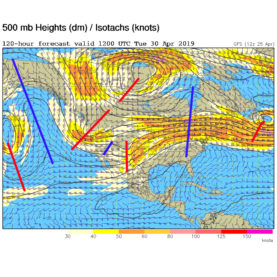
Sunday, a strong cold front arrives. The wind shift to the north occurs around 2 pm Sunday. This is powered by a deep mean trough approaching and a short wave out front (two red dashes over Colorado and West Colorado - Figure 3). Weatherunderground.com is giving us about 1/10th to 2/10ths inch of rain Sunday evening.

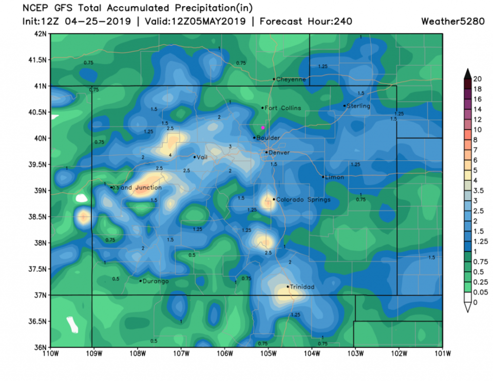
We cool to the mid to upper 30's F Monday morning. There is a chance the precipitation will fall as snow for a few hours (the purple colored precipitation depiction in Figure 4). For rainfall over the next 10 days (mainly this storm) we are in the 0.75 to 1 inch zone now (it is dropping again!). For snowfall (!) we pick up 3-4 inches from the GFS while Boulder and north Denver see up to 6 inches. Sort of hard to believe, but worth watching.


Figure 1: The forecast surface map for Friday PM from NCEP.
Figure 2: The forecast surface map for Saturday AM from NCEP.
Figure 3: The 500mb forecast upper air analysis for Monday morning. Pink dot is Longmont. Red lines are troughs, blue lines are ridges.
Figure 4: the graphical forecast for the next 10 days for Longmont, CO from weatherunderground.com
Figure 5: the forecast accumulated precipitation map from the GFS and weather5280.com for Colorado through Sunday afternoon.
Figure 6: the forecast accumulated precipitation map from the NAM and tropicaltidbits.com for Colorado and areas east and south, through Sunday afternoon.
Figure 7: the forecast accumulated precipitation map from the GEM and tropicaltidbits.com for Colorado and areas east and south, through Sunday afternoon.
Figure 8: the forecast accumulated precipitation map from the GFS and weather5280.com for Colorado,over the next 10 days.
Figure 9: the forecast accumulated snowfall map from the GFS and weather5280.com for Colorado,over the next 10 days.

Current Weather

Cloudy

Cloudy

39°F

UV Index
0 Low
Pressure
30.17 Steady
Visibility
8 miles
Dewpoint
29 °F
Humidity
68%
Wind
SSE 1.6 mph
Gust
3.8 mph
Wind Chill
39 °F

Hourly Forecast

Today
5 AM
38°F
Showers
Today
6 AM
37°F
Intermittent clouds
Today
7 AM
39°F
Partly sunny
Today
8 AM
42°F
Mostly sunny
Today
9 AM
45°F
Mostly sunny
Today
10 AM
49°F
Mostly sunny
Today
11 AM
53°F
Mostly sunny
Today
12 PM
55°F
Mostly sunny
Today
1 PM
59°F
Mostly sunny
Today
2 PM
61°F
Partly sunny
Today
3 PM
63°F
Partly sunny
Today
4 PM
64°F
Intermittent clouds

7 Day Forecast

Partly sunny

Saturday

66 °F

Partly sunny and not as warm


Mostly clear

Saturday Night

40 °F

Clear to partly cloudy


Mostly cloudy

Sunday

76 °F

Mostly cloudy and warmer; breezy in the afternoon


Mostly cloudy

Sunday Night

47 °F

Rather cloudy; breezy late


Windy

Monday

60 °F

Very windy; cloudy and cooler


Intermittent clouds

Monday Night

43 °F

Partly cloudy


Intermittent clouds

Tuesday

62 °F

Windy with times of clouds and sun


Partly cloudy

Tuesday Night

36 °F

Partly cloudy


Mostly cloudy

Wednesday

60 °F

Turning cloudy


Intermittent clouds

Wednesday Night

35 °F

Partly cloudy


Sunrise and Sunset

Sunrise
5:55 AM
Sunset
7:59 PM

Based on AccuWeather data