Skip to content

Next Storm/Next Snow Forecast Discussion from the Cherrywood Observatory – April 30, 2019

This content was originally published by the Longmont Observer and is licensed under a Creative Commons license.

In Brief:

While 1 inch of snow has built up on grassy surfaces in Longmont, 1-3 inches of additional snow is possible overnight ending/changing to rain showers in the mid-morning Tuesday. Rain showers continue through Thursday AM. We warm to the 70'sF and dry out for the weekend.

Forecast Discussion:

The storm is underway. I have about 1 inch of snow on my rapidly greening grass. Snow will continue off and on through the night Monday into Tuesday morning. By 11am, we will be up to about 42F. The snow should change to rain around then. We keep warming to the lower 50'sF into the afternoon.

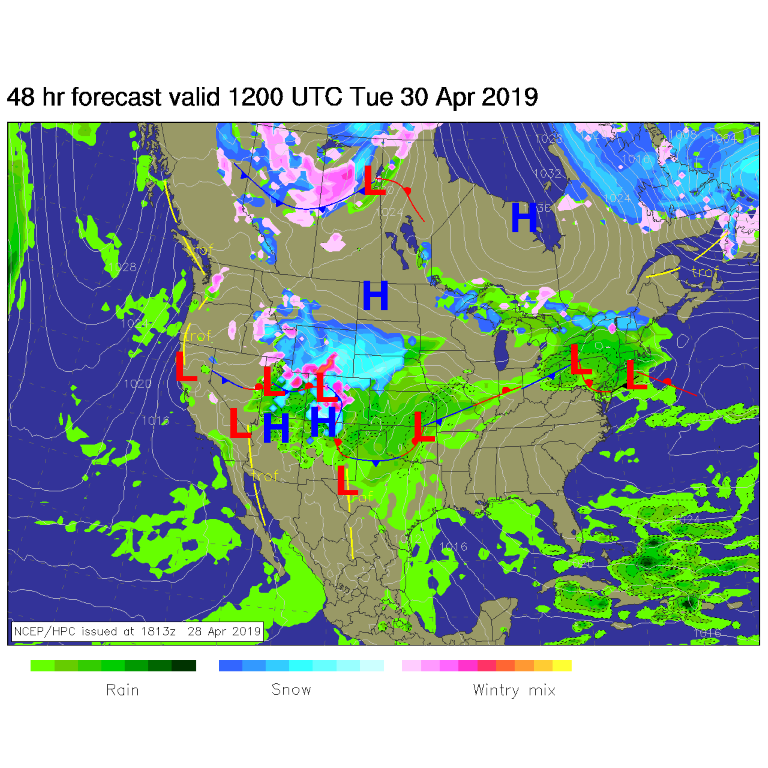
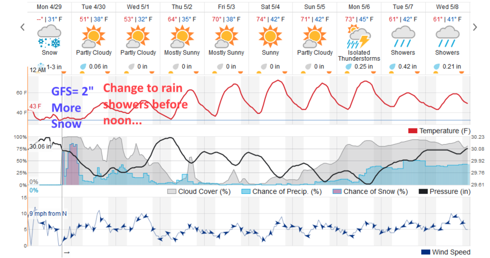
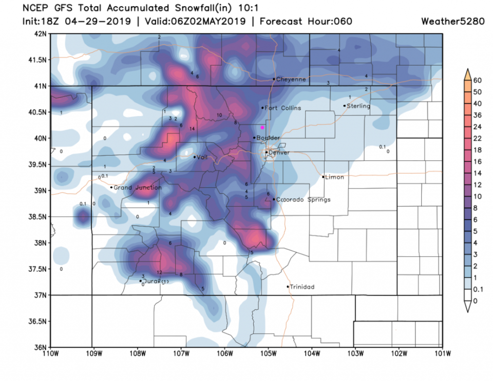
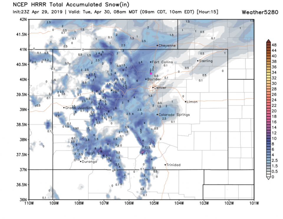
How much snow is left to fall in Longmont? The storm is large and very wet, but rainfall isn't far away to the south in the morning (Figure 1). The heavy snow period occurs before dawn Tuesday (Figure 2). The weatherunderground.com model has 1-3 inches yet to fall. The GFS (Figure 3) give us about 2 inches by dawn. The HRRR (Figure 4) gives us about 2.5-3 inches. That seems like a pretty good consensus. The GEM (not shown) also has about 2 inches but the NAM (not shown) gives us 7 inches. I think one of these models is not like the others.

I will point out that we never had a period of rain, as I predicted. I'm slapping my wrists.

The longer range forecast:

Rain showers continue from Tuesday to Thursday afternoon now and then. We warm to the 60'sF Thursday and the 70'sF for the weekend.

In the distant distant future (next Monday-Wednesday) there is another stormy and wet period possible. More later!

Figure 1: The forecast surface map for Tuesday AM from NCEP.
Figure 2: the graphical forecast for the next 10 days for Longmont, CO from weatherunderground.com
Figure 3: the forecast accumulated snowfall map from the GFS and weather5280.com for Colorado,over the next 2.5 days.
Figure 4: the forecast accumulated snowfall map from the HRRR and weather5280.com for Colorado ending 8am Tuesday.

Current Weather

Sunny

Sunny

58°F

UV Index
6 High
Pressure
30.06 Falling
Visibility
7 miles
Dewpoint
33 °F
Humidity
39%
Wind
SE 3.8 mph
Gust
7.9 mph
Wind Chill
58 °F

Hourly Forecast

Today
3 PM
62°F
Partly sunny
Today
4 PM
65°F
Intermittent clouds
Today
5 PM
66°F
Intermittent clouds
Today
6 PM
65°F
Intermittent clouds
Today
7 PM
63°F
Intermittent clouds
Today
8 PM
60°F
Mostly clear
Today
9 PM
57°F
Mostly clear
Today
10 PM
55°F
Mostly clear
Today
11 PM
52°F
Mostly clear
Tomorrow
12 AM
50°F
Mostly clear
Tomorrow
1 AM
48°F
Mostly clear
Tomorrow
2 AM
47°F
Mostly clear

7 Day Forecast

Intermittent clouds

Saturday

66 °F

Not as warm with intervals of clouds and sunshine


Mostly clear

Saturday Night

39 °F

Clear to partly cloudy


Mostly cloudy

Sunday

77 °F

Mostly cloudy and warmer; breezy in the afternoon


Mostly cloudy

Sunday Night

45 °F

Rather cloudy; breezy late


Windy

Monday

60 °F

Very windy; cloudy and cooler


Intermittent clouds

Monday Night

43 °F

Partly cloudy


Intermittent clouds

Tuesday

62 °F

Times of clouds and sun; windy in the afternoon


Partly cloudy

Tuesday Night

36 °F

Partly cloudy


Intermittent clouds

Wednesday

60 °F

Times of clouds and sun


Intermittent clouds

Wednesday Night

35 °F

Partly cloudy


Sunrise and Sunset

Sunrise
5:55 AM
Sunset
7:59 PM

Based on AccuWeather data