Skip to content

Next Storm/Next Snow Forecast Discussion from the Cherrywood Observatory – April 8, 2019

This content was originally published by the Longmont Observer and is licensed under a Creative Commons license.

Forecast discussion:

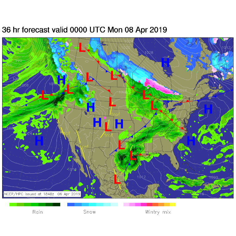
Another sprinkle moved through on Saturday, but it wasn't much. Now the real first warm-up of the year gets underway. From Sunday afternoon, high pressure is sitting in place over our state (Figure 1). By Monday morning, a strong ridge is moving in from the west (Figure 2). By Tuesday afternoon we could be almost 25°F above normal (Figure 3). Tuesday's high will probably break 80°F for the first time in forever.

The longer range forecast:

Still looking at Figure 4, the next day, Wednesday, a front moves in during the morning and we have about 18 hours of a really good chance of rain. Ground temperatures will be high and we will just be cooling to freezing at the end of the main precipitation event - so snow, if it occurs, it won't stick around much.

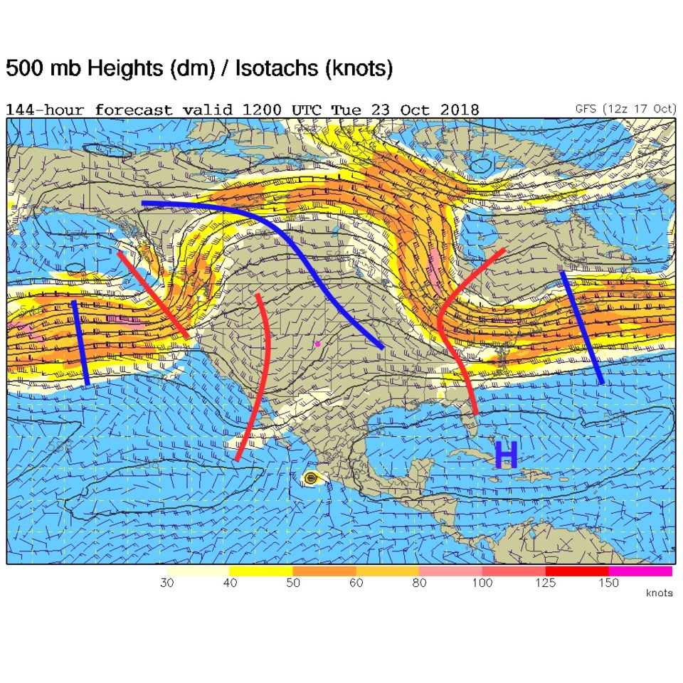
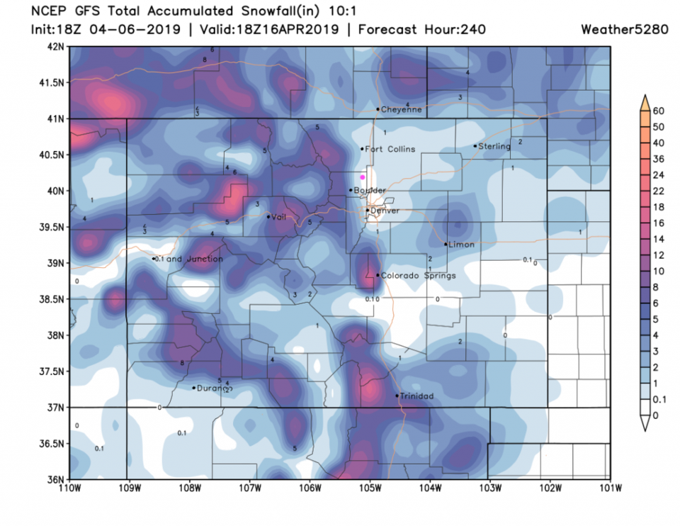
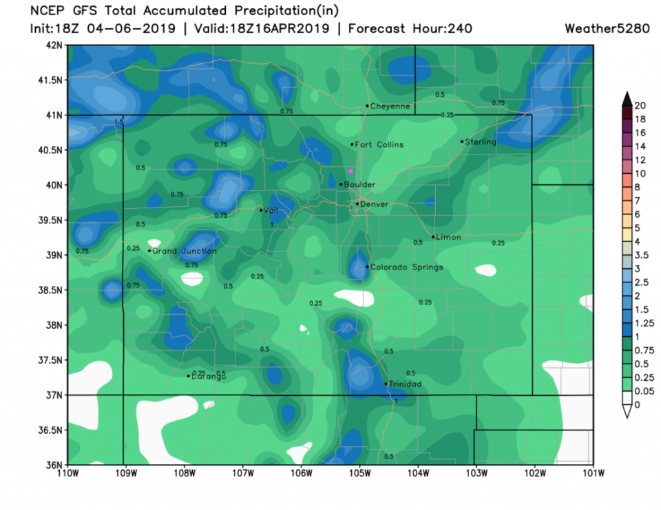
This storm system is caused by a strong short wave moving in with a closed-off low over Utah Wednesday AM (Figure 5). Our 10 day snow totals for the state look like a foot in the higher mountains, but maybe a trace/coating down around Longmont (Figure 6). For rainfall, weatherunderground.com gives us about 1/4th of an inch (Figure 4) while the GFS gives us 1/2 to 3/4th of an inch. Sorry if you were hoping for snow, but it is leaving the forecast (though there is still a lot of disagreement among the models for what happens Thursday on - so I'm not focusing on that longer long range forecast yet).

Figure 1: The forecast surface map for Sunday PM from NCEP.
Figure 2: The 500mb forecast upper air analysis for Monday morning next week. Pink dot is Longmont. Red lines are troughs, blue lines are ridges.
Figure 3: The forecast temperature departure from normal map from the GFS and weather5280.com for Colorado, Tuesday PM.
Figure 4: the graphical forecast for the next 10 days for Longmont, CO from weatherunderground.com
Figure 5: The 500mb forecast upper air analysis for Wednesday morning next week. Pink dot is Longmont. Red lines are troughs, blue lines are ridges.
Figure 6: the forecast accumulated snowfall map from the GFS and weather5280.com for Colorado, over the next 10 days.
Figure 7: the forecast accumulated precipitation map from the GFS and weather5280.com for Colorado, over the next 10 days.

Current Weather

Mostly cloudy

Mostly cloudy

56°F

UV Index
0 Low
Pressure
29.88 Steady
Visibility
8 miles
Dewpoint
37 °F
Humidity
49%
Wind
NW 4 mph
Gust
11.3 mph
Wind Chill
56 °F

Hourly Forecast

Today
8 PM
54°F
Showers
Today
9 PM
51°F
Intermittent clouds
Today
10 PM
48°F
Intermittent clouds
Today
11 PM
45°F
Intermittent clouds
Tomorrow
12 AM
44°F
Partly cloudy
Tomorrow
1 AM
42°F
Partly cloudy
Tomorrow
2 AM
41°F
Partly cloudy
Tomorrow
3 AM
40°F
Partly cloudy
Tomorrow
4 AM
39°F
Partly cloudy
Tomorrow
5 AM
38°F
Partly cloudy
Tomorrow
6 AM
37°F
Partly cloudy
Tomorrow
7 AM
39°F
Partly sunny

7 Day Forecast

Partly sunny w/ t-storms

Sunday

64 °F

Warmer with times of clouds and sun; a thundershower in spots late this afternoon


Intermittent clouds

Sunday Night

37 °F

An evening shower in spots; otherwise, partly cloudy


Partly sunny

Monday

70 °F

Partly sunny and pleasant


Intermittent clouds

Monday Night

43 °F

Partly cloudy


Mostly sunny

Tuesday

73 °F

Mostly sunny and pleasant


Intermittent clouds

Tuesday Night

41 °F

Clearing


Intermittent clouds

Wednesday

65 °F

Times of sun and clouds


Intermittent clouds

Wednesday Night

39 °F

A thundershower in spots in the evening; otherwise, partly cloudy


Rain

Thursday

53 °F

Cooler with occasional rain and drizzle; breezy in the morning


Partly cloudy

Thursday Night

32 °F

Partly cloudy


Sunrise and Sunset

Sunrise
6:03 AM
Sunset
7:53 PM

Based on AccuWeather data