Skip to content

Next Storm/Next Snow Forecast Discussion from the Cherrywood Observatory – August 22, 2019

This content was originally published by the Longmont Observer and is licensed under a Creative Commons license.

In Brief:

We have two more days of summer thunderstorms with a Marginal Risk painted for the area Thursday PM. The weekend will be hot and dry - getting close to 100F again. Next week a stout cold front will invade Tuesday-ish and we may only see highs in the 70'sF mid to late week. Woohoo!

Forecast Discussion:

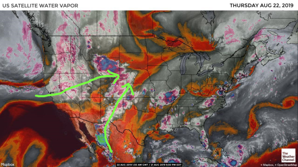
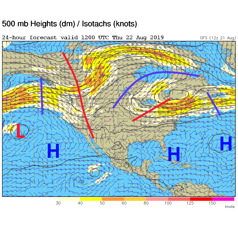
Figure 1 shows some moisture up the spine of the Rockies and Pacific moisture coming in from the west with surface moisture being pushed back to the west from the big thunderstorm complex that drifted to the southeast through the Midwest last night. There is still moisture around Thursday and with the short wave fairly close to the state to the west (Figure 2) - we'll see more storms.

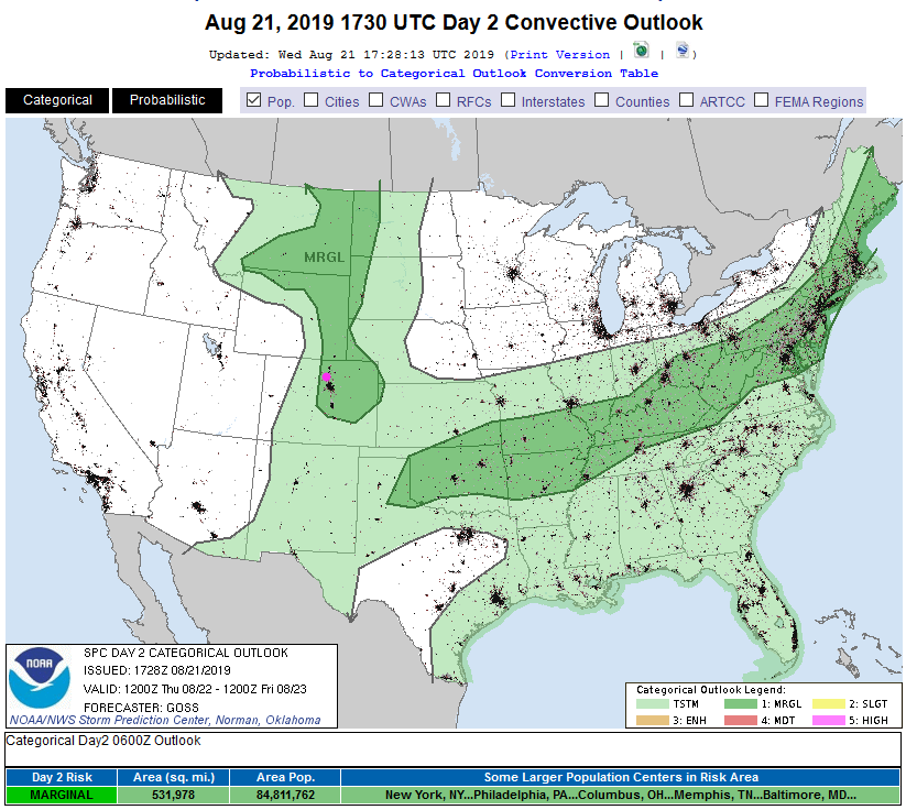
The SPC has painted us with a Marginal Risk again Thursday with hail and high winds being most likely (Figure 3). (It mostly skipped Longmont on Wednesday -but some Coloradans got hit.)

The Longer Range Forecast:

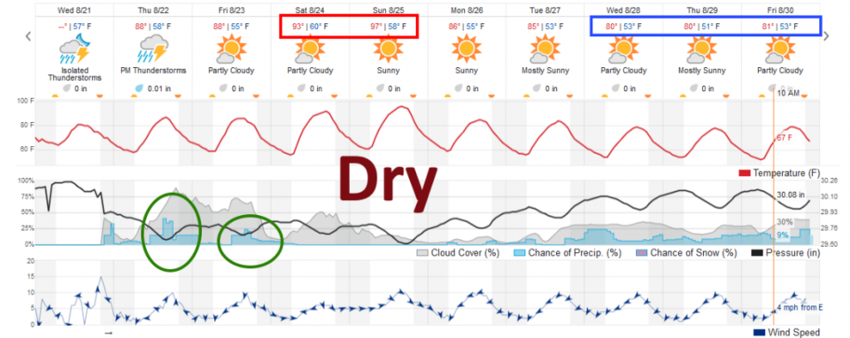
Figure 4 shows that serious heat and bone dry conditions will dominate the state this weekend. A deep trough is shaping up in the models that will blast the center of the nation with a lot of cold air. We "may" only see lower 70'sF after mid-week (not reflected in the weatherunderground model shown). Here's to hoping!

Figure 1: the water vapor satellite image (browns/reds are dry air, whites and light grey is moist air, purple/blue is ice and high cloud tops). From the the Weather Channel from Wednesday evening.
Figure 2: The 500mb forecast upper air analysis for Thursday AM. Pink dot is Longmont. Red lines are troughs, blue lines are ridges.
Figure 3: The severe storm weather forecast for the U.S. from the Storm Predication Center in Norman, OK. Made Wednesday for Thursday.
Figure 4: the graphical forecast for the next 10 days for Longmont, CO from weatherunderground.com

Current Weather

Cloudy

Cloudy

42°F

UV Index
1 Low
Pressure
29.96 Steady
Visibility
8 miles
Dewpoint
40 °F
Humidity
92%
Wind
W 1.1 mph
Gust
2.8 mph
Wind Chill
42 °F

Hourly Forecast

Today
10 AM
47°F
Mostly cloudy
Today
11 AM
51°F
Mostly cloudy
Today
12 PM
53°F
Cloudy
Today
1 PM
56°F
Thunderstorms
Today
2 PM
58°F
Cloudy
Today
3 PM
59°F
Thunderstorms
Today
4 PM
60°F
Mostly cloudy
Today
5 PM
62°F
Mostly cloudy
Today
6 PM
60°F
Mostly cloudy
Today
7 PM
58°F
Intermittent clouds
Today
8 PM
55°F
Intermittent clouds
Today
9 PM
52°F
Intermittent clouds

7 Day Forecast

Thunderstorms

Sunday

62 °F

Mostly cloudy and warmer with a thundershower in spots


Intermittent clouds

Sunday Night

38 °F

Partly cloudy


Partly sunny

Monday

70 °F

Partly sunny, pleasant and warmer


Intermittent clouds

Monday Night

44 °F

Partly cloudy


Mostly sunny

Tuesday

73 °F

Mostly sunny and pleasant


Intermittent clouds

Tuesday Night

41 °F

Clearing


Intermittent clouds

Wednesday

65 °F

Times of sun and clouds


Intermittent clouds

Wednesday Night

39 °F

A thundershower in spots in the evening; otherwise, partly cloudy


Rain

Thursday

56 °F

Cooler with occasional rain and drizzle; breezy in the morning


Partly cloudy

Thursday Night

32 °F

Partly cloudy


Sunrise and Sunset

Sunrise
6:03 AM
Sunset
7:53 PM

Based on AccuWeather data