This content was originally published by the Longmont Observer and is licensed under a Creative Commons license.
In Brief:
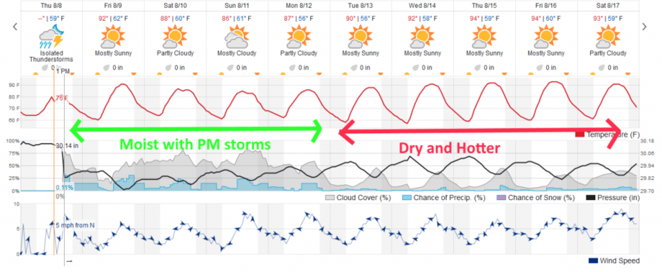
Moisture makes a return on Saturday and Sunday... with the high retreating a bit further to the southeast, through Texas. Short waves and easterly flow will interact with the mountains and daytime heating to give us better storm chances each afternoon. Things begin to dry out Monday then storm chances drop to near zero with highs in the mid 90'sF the rest of next week.
8:30am Sunday update
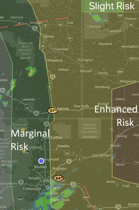
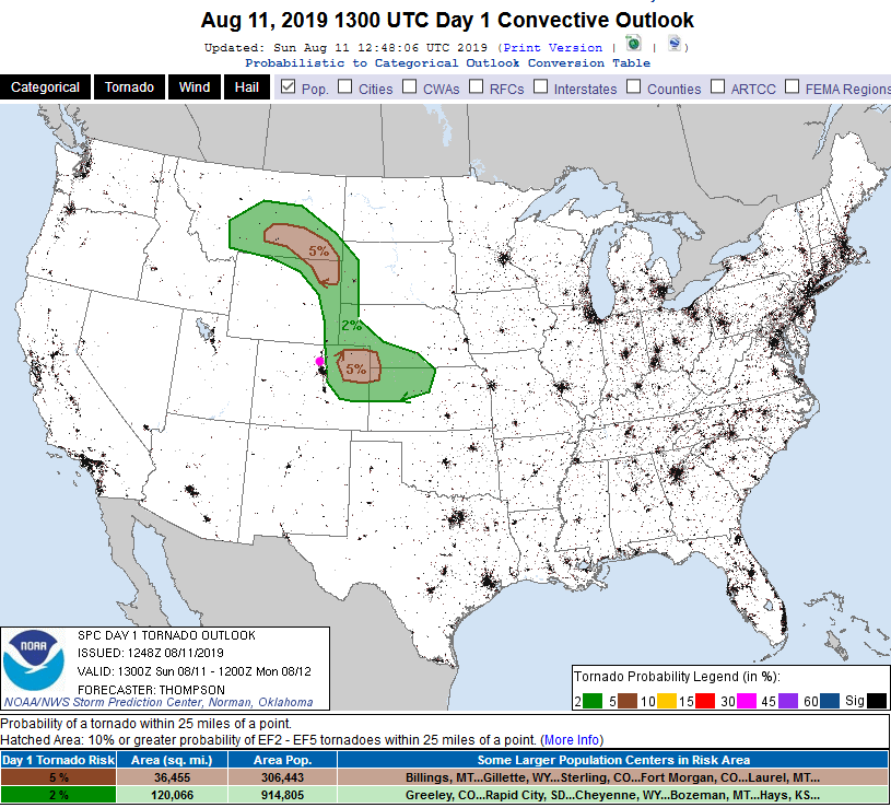
Things are on track from the update yesterday. Severe weather is predicted for today with a Marginal risk (1 on a scale of 1-5) for Estes Park, Longmont and areas right along I-25. Just to the east is a Slight risk (2 out of 5) and further out on the eastern Plains an Enhanced Risk (3 out of 5) - Figure 3 update. The main risk for all areas is for large hail and damaging winds. In the Slight and Enhanced risk areas, there is an increasing chance of tornadoes (Figure 4 update) the further east you go.
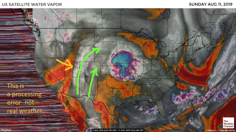
This is all created by one last big blob of moisture coming up from the tropics (Figure 5 update) and an upper level disturbance (ripple in the flow, pool of cool air) moving out of western New Mexico up to NE Colorado later today. Dry air (yellow arrow in Figure 5 update) is roaring in from the west and will sweep a lot of the moisture in the state out later this evening.
The main window for severe weather around the foothills and I-25 will be 1-5pm with activity continuing later into the evening out east. Reopen your weather apps and make sure you have them running in the background today! (Footnote, the local NWS has expressed concern that the clouds and moisture in place this morning may limit severe chances along and west of I-25 with less sunshine and heating. It may not rock much around here, but still, be prepared.)
End 8:30am Sunday update.
9:30pm update:
Cool air continued to flow in from the north stabilizing the atmosphere on Saturday. Nothing big happened in Longmont Saturday. Friday night's storm did drop impressive rainfall though - and almost solely across our town (Figure 1 update).
More moisture returns, and heating, and upper air support - on Sunday. We have one more good chance of thunderstorms Sunday afternoon. Some are expected to approach severe limits with a Marginal risk (1 on a scale of 1-5) for severe weather across most of Longmont today, and a slight risk (2 on a scale of 1-5) over the eastern edge of town and eastward. Golf ball sized hail, damaging winds, and locally flooding rains are expected - more the further east one goes (Figure 2 update). Even a tornado or two might be possible out on the Plains. Keep an eye on your apps Sunday. We dry out a good amount on Monday- then dry out completely on Tuesday - and heat up to the mid to upper 90'sF. (Sorry for the brief post, but the clock is hard to beat sometimes.)
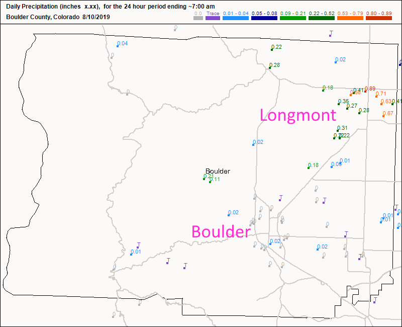
Figure 1 update: CoCoRaHS precipitation reports up through Saturday 7am for the prior 24 hours.
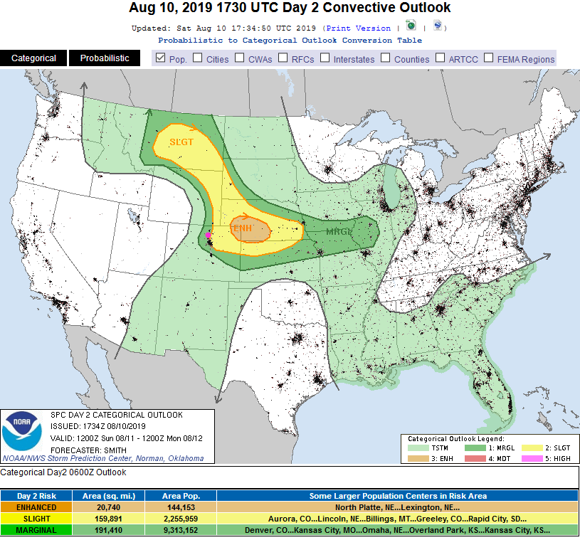
Figure 2 update: The SPC forecast for severe weather across the nation from Norman OK made Saturday for Sunday.
End 9:30pm update.
9pm update:
Storms did form after sunset probably along an outflow boundary/cool front that came down out of Wyoming in the afternoon. The central and northern parts of town picked up 0.5 to 1.0 inch of water.
There is still no severe weather risk predicted for the I-25 corridor (but there is just to the east of that line) for Saturday. There is a Marginal Risk for Longmont and areas along I-25 predicted for Sunday.
End 9pm Update.
Forecast Discussion:
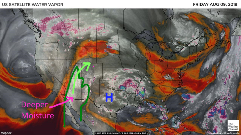
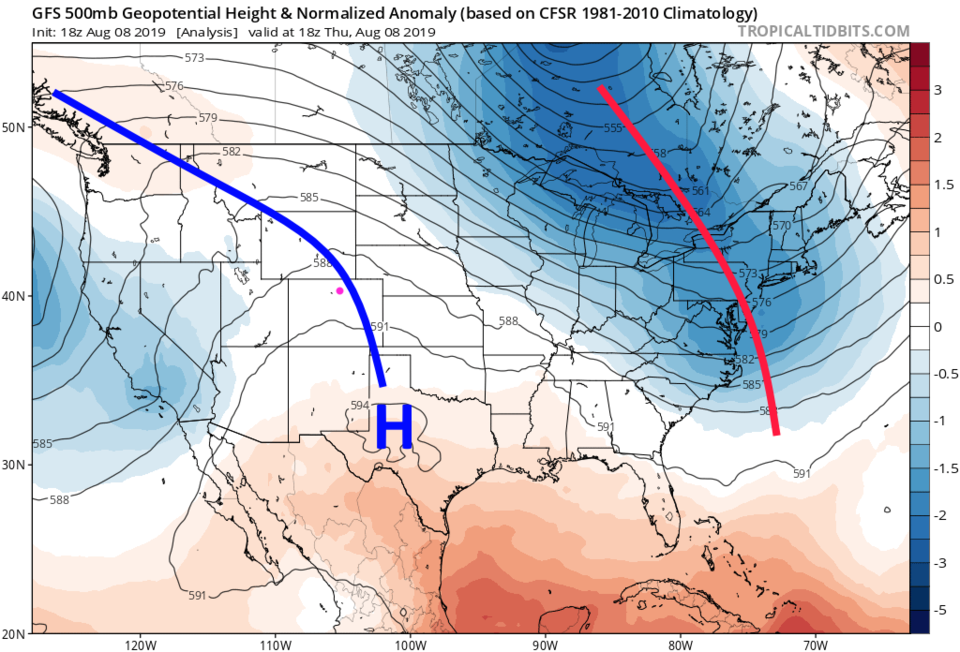
The water vapor satellite image for Friday PM shows a new blob of tropical moisture traveling up around the high pressure center in Texas (Figure 1). On Friday, westerly winds brought in dry air over northern Colorado and the upper level ridge was parked overhead (Figure 2). For Saturday, the ridge is still there, but weakens with the low on the west coast digging in a bit closer to our state.
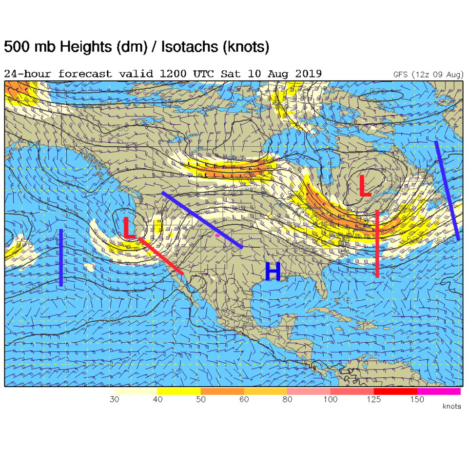
This means a better chance of afternoon thunderstorm coverage (Figure 5). Severe weather chances (at this time) are expected to remain about 30-40 miles east of Longmont and off further to the east. I'll update this post if needed in the morning.
The Longer Range Forecast:
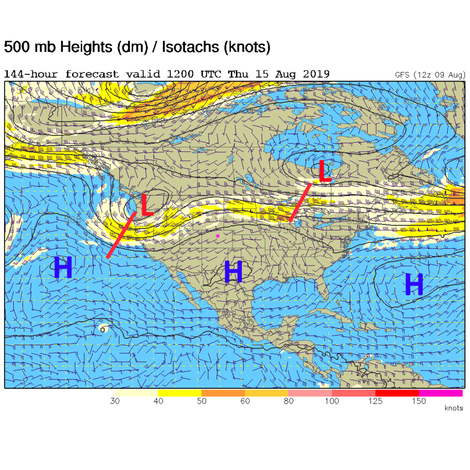
Sunday's storm coverage will depend on the amount of convection to our east Saturday night and the timing of small short waves in the atmosphere - it is tricky to say how stormy Sunday afternoon will be (Figure 5). It is clear that a return of the ridge/ high pressure center (Figure 4) and a drying begins Monday and we warm to the 90'sF Tuesday and beyond.
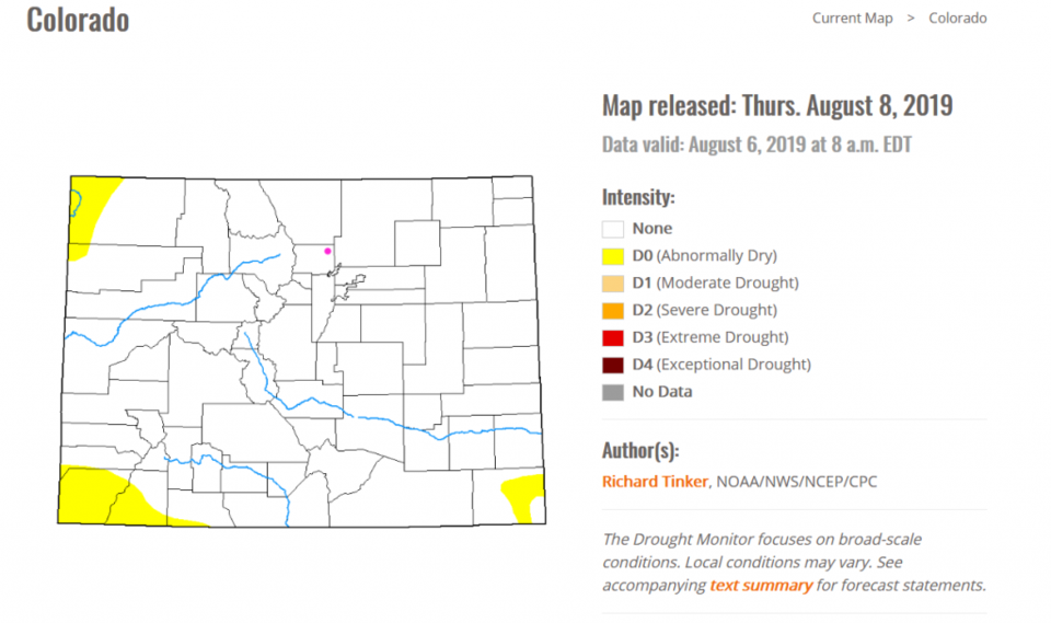
Speaking of drying, we haven't looked a the drought index in quite a while (since we went weeks and weeks with 100% drought free conditions in Colorado). Figure 6 shows just a touch of dryness beginning to form at the NW, SW, and SE corners of the state. Things are pretty nice and moist still - especially for August.