Skip to content

Next Storm/Next Snow Forecast Discussion from the Cherrywood Observatory – December 11, 2018

This content was originally published by the Longmont Observer and is licensed under a Creative Commons license.

Forecast Discussion:

If the forecasters at WeatherBell are correct, there is some serious cold winter-like conditions on their way around Christmas and beyond... but models disagree on this, so it will be fun to watch.  In the meantime, unusually warm beautiful weather is the story (except for our brief mid-week cold front).

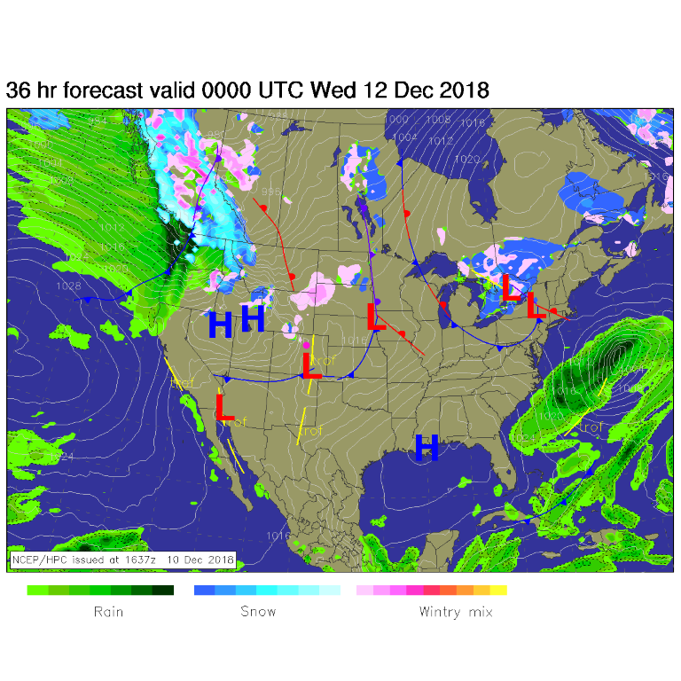
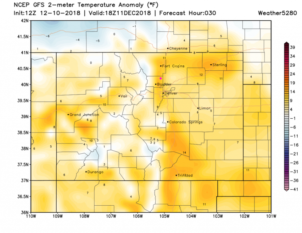
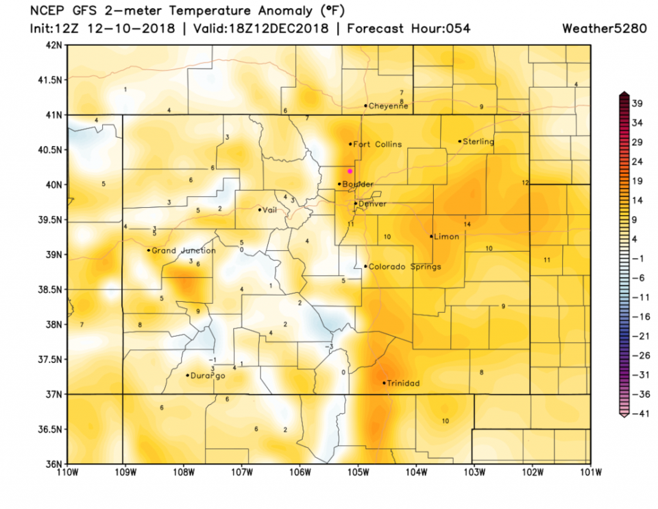
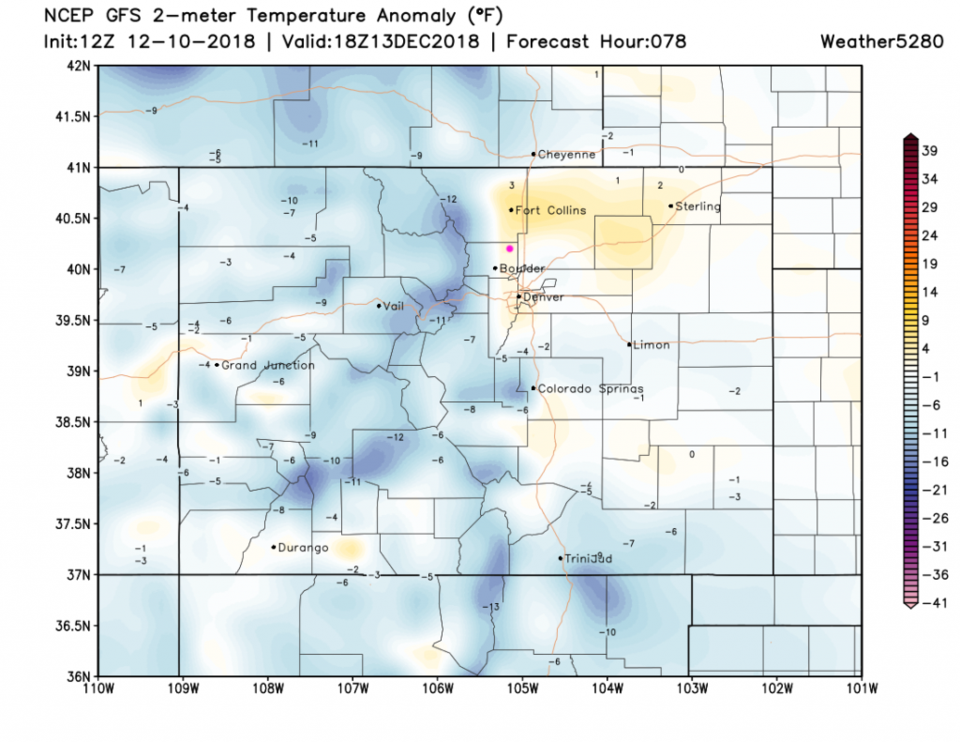
A very weak, dry cold front heads through today, but temperatures won't reflect that (Figure 1). Figure 2 shows us about 10F above normal today.  Figure 3 has us maybe 12F above average tomorrow.  The cold front comes through later Wednesday, so Thursday (Figure 4) cools to near average around town (colder in the mountains).  Figure 4 does show a bit of down slope warming around Ft. Collins and eastward.

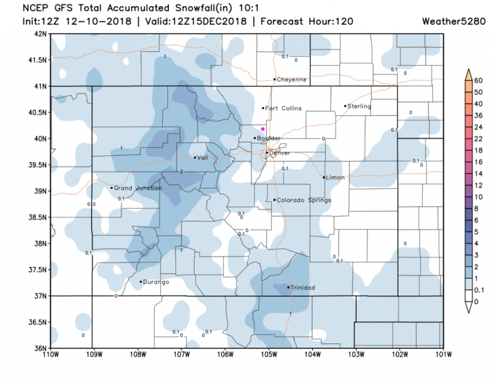
Figure 5 is the snowfall over the next 5 days (from the GFS) and we have measurable snow up into the southwest side of Longmont - a dusting to a coating is likely after that front comes through. The Western Slopes get 2-3 inches (with locally higher amounts).

Figure 1: The forecast surface map for Tuesday night. From NCEP.

Figure 2: The surface temperature departure from normal for Tuesday noon from weather5280.com

Figure 3: The surface temperature departure from normal for Wednesday noon from weather5280.com

Figure 4: The surface temperature departure from normal for Thursday noon from weather5280.com

Figure 5: The forecast accumulated snow map from the GFS and weather5280.com for Colorado, through the next 5 days.

The longer term forecast:

We warm up for the weekend and have no more measurable precipitation expected for the next 10 days.  Enjoy the quiet-ness!

Current Weather

Cloudy

Cloudy

39°F

UV Index
0 Low
Pressure
29.95 Rising
Visibility
8 miles
Dewpoint
38 °F
Humidity
95%
Wind
NW 0.5 mph
Gust
1.6 mph
Wind Chill
39 °F

Hourly Forecast

Today
8 AM
39°F
Thunderstorms
Today
9 AM
42°F
Cloudy
Today
10 AM
46°F
Mostly cloudy
Today
11 AM
49°F
Mostly cloudy
Today
12 PM
52°F
Cloudy
Today
1 PM
55°F
Cloudy
Today
2 PM
57°F
Cloudy
Today
3 PM
58°F
Thunderstorms
Today
4 PM
59°F
Mostly cloudy
Today
5 PM
61°F
Mostly cloudy
Today
6 PM
59°F
Mostly cloudy
Today
7 PM
57°F
Intermittent clouds

7 Day Forecast

Thunderstorms

Sunday

61 °F

Mostly cloudy and warmer; a thundershower in spots this afternoon


Partly cloudy w/ t-storms

Sunday Night

37 °F

An evening thunderstorm in parts of the area; otherwise, partly cloudy


Partly sunny

Monday

70 °F

Partly sunny, pleasant and warmer


Intermittent clouds

Monday Night

43 °F

Partly cloudy


Mostly sunny

Tuesday

73 °F

Mostly sunny and pleasant


Mostly cloudy

Tuesday Night

41 °F

Mostly cloudy


Intermittent clouds

Wednesday

65 °F

Times of sun and clouds with a passing shower in the afternoon


Intermittent clouds

Wednesday Night

39 °F

A thundershower in spots in the evening; otherwise, partly cloudy


Rain

Thursday

49 °F

Chilly with rain and drizzle


Partly cloudy

Thursday Night

28 °F

Partly cloudy


Sunrise and Sunset

Sunrise
6:03 AM
Sunset
7:53 PM

Based on AccuWeather data