Skip to content

Next Storm/Next Snow Forecast Discussion from the Cherrywood Observatory – December 12, 2018

This content was originally published by the Longmont Observer and is licensed under a Creative Commons license.

Forecast Discussion:

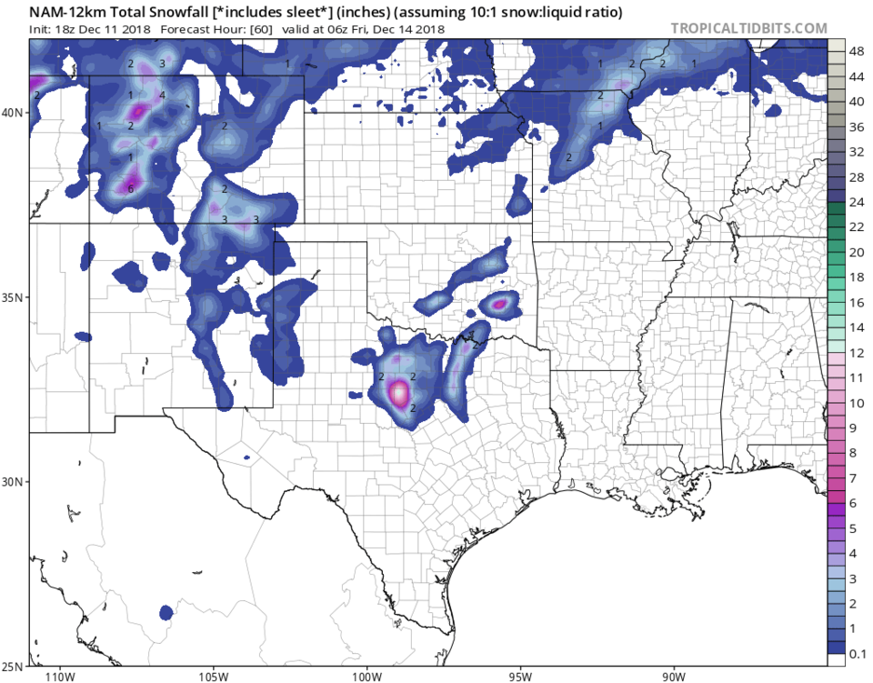
The most exciting weather of the next 10 days happens over the next 24 hours (unless you liked the down-slope gusts on Tuesday). Go out and enjoy our cold front! By this evening, the cold front has swept past us and is already down into New Mexico and parts unknown (Figure 1). According to NCEP, up-slope flow will be strong enough early Thursday AM to give us some sleet/snow mix (Figure 2).

Weatherunderground shows the cold front passing Longmont around 1 PM with a dip in the pressure field and a steady temperature decline after that time (Figure 3). BUT they have no precipitation at all, just a bunch of north wind is howling by, according to that source.

Figure 4 is the GFS and it has a coating to an inch of snow for Boulder, but no snow to a coating of snow possible for Longmont. Figure 5, the NAM, doesn't paint any snow in NE Boulder county either.

Figure 1: The forecast surface map for Wednesday night. From NCEP.

Figure 2: The forecast surface map for Thursday AM. From NCEP.

Figure 3: the graphical forecast for the next 10 days forecast for Longmont, CO from weatherunderground.com

Figure 4: The forecast accumulated snow map from the GFS and weather5280.com for Colorado, through the next 10 days.

Figure 5: The forecast accumulated snow map from the NAM and tropicaltidbits.com for the southern plains, through the next 2.5 days.

The longer range forecast:

Back to Figure 3- you'll see that day time temperatures rapidly return to mid to upper 50's F with lows at or above freezing off to the end of Fall 12/20. Christmas is almost in sight on this model and there are no big snow storms or cold air expected. WeatherBell is still calling for a big cold spell just before Christmas - a well placed low or front could 'still' give us snow. All hope is not yet lost. More later!

Current Weather

Partly cloudy

Partly cloudy

47°F

UV Index
0 Low
Pressure
29.96 Rising
Visibility
8 miles
Dewpoint
40 °F
Humidity
76%
Wind
SW 1.7 mph
Gust
4 mph
Wind Chill
47 °F

Hourly Forecast

Tomorrow
12 AM
44°F
Partly cloudy
Tomorrow
1 AM
43°F
Partly cloudy
Tomorrow
2 AM
42°F
Partly cloudy
Tomorrow
3 AM
41°F
Partly cloudy
Tomorrow
4 AM
39°F
Partly cloudy
Tomorrow
5 AM
38°F
Partly cloudy
Tomorrow
6 AM
37°F
Partly cloudy
Tomorrow
7 AM
40°F
Partly sunny
Tomorrow
8 AM
45°F
Mostly sunny
Tomorrow
9 AM
50°F
Mostly sunny
Tomorrow
10 AM
56°F
Partly sunny
Tomorrow
11 AM
59°F
Partly sunny

7 Day Forecast

Intermittent clouds

Sunday

64 °F

Warmer with times of clouds and sun


Partly cloudy w/ showers

Sunday Night

37 °F

A couple of brief showers late this evening; partly cloudy


Partly sunny

Monday

70 °F

Partly sunny and pleasant


Intermittent clouds

Monday Night

43 °F

Partly cloudy


Mostly sunny

Tuesday

73 °F

Mostly sunny and pleasant


Intermittent clouds

Tuesday Night

41 °F

Clearing


Intermittent clouds

Wednesday

65 °F

Times of sun and clouds


Intermittent clouds

Wednesday Night

39 °F

A thundershower in spots in the evening; otherwise, partly cloudy


Rain

Thursday

53 °F

Cooler with occasional rain and drizzle; breezy in the morning


Partly cloudy

Thursday Night

32 °F

Partly cloudy


Sunrise and Sunset

Sunrise
6:03 AM
Sunset
7:53 PM

Based on AccuWeather data