Skip to content

Next Storm/Next Snow Forecast Discussion from the Cherrywood Observatory – December 17, 2018

This content was originally published by the Longmont Observer and is licensed under a Creative Commons license.

Forecast Discussion:

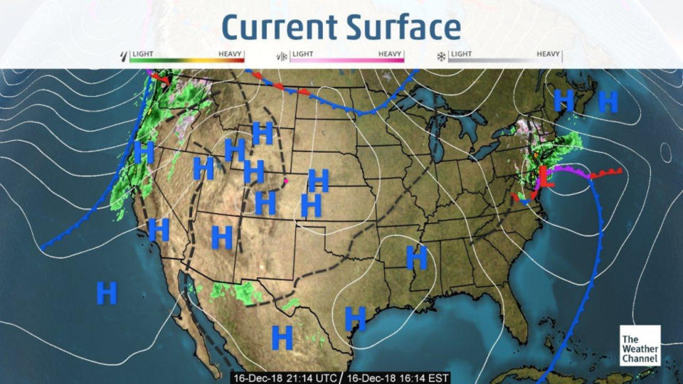
According to the Sunday surface map (Figure 1) - we seem to have high pressure around.  (I did *not* photoshop in all those H's). We are dry with abnormally high temperatures. Let's look at the next storm...

Figure 1: The current surface map from Sunday PM and the Weather Channel.

The longer range forecast:

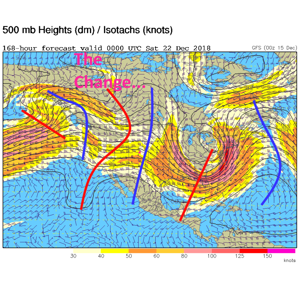
The big western upper air ridge finally begins to break down at the end of the week (the red trough cutting into the western U.S. in Figure 2). A weak trough will kick up strong winds Wednesday (Figure 3) - then the main-event-cold front hits Friday afternoon. After that we do get a chance of snow Saturday evening, Sunday morning and a hint of a Christmas morning snow (just a 10% chance of precipitation, don't rent a photographer yet).

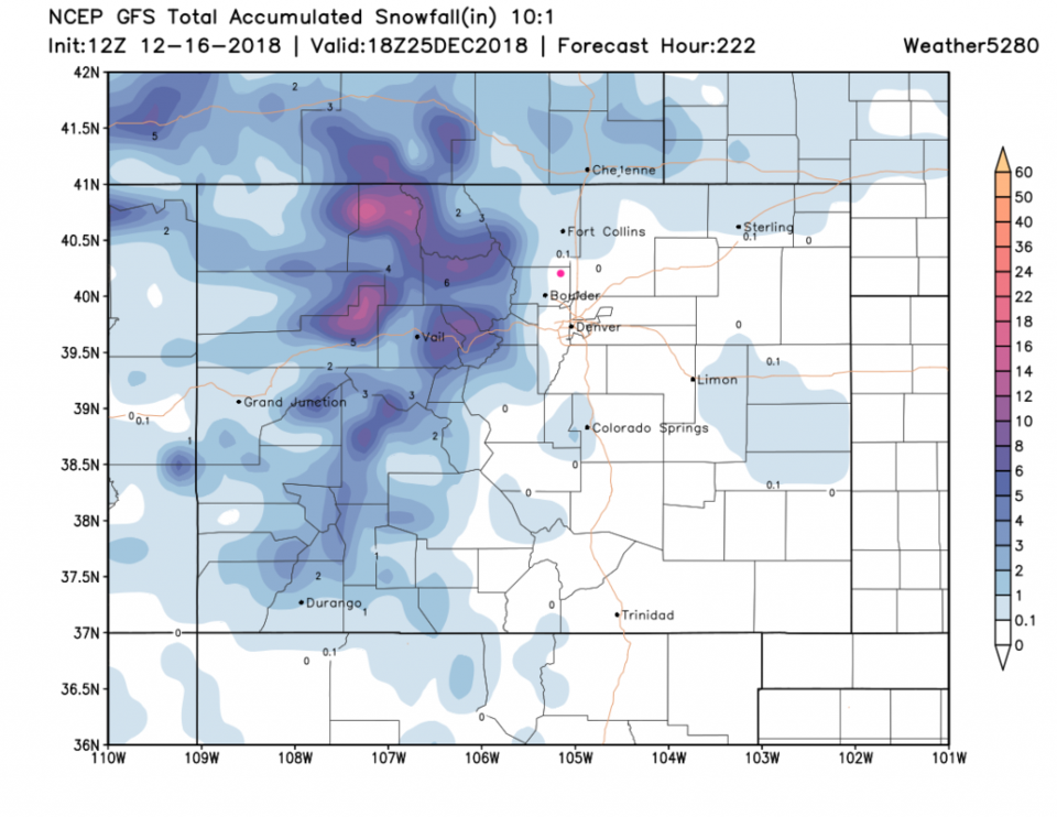
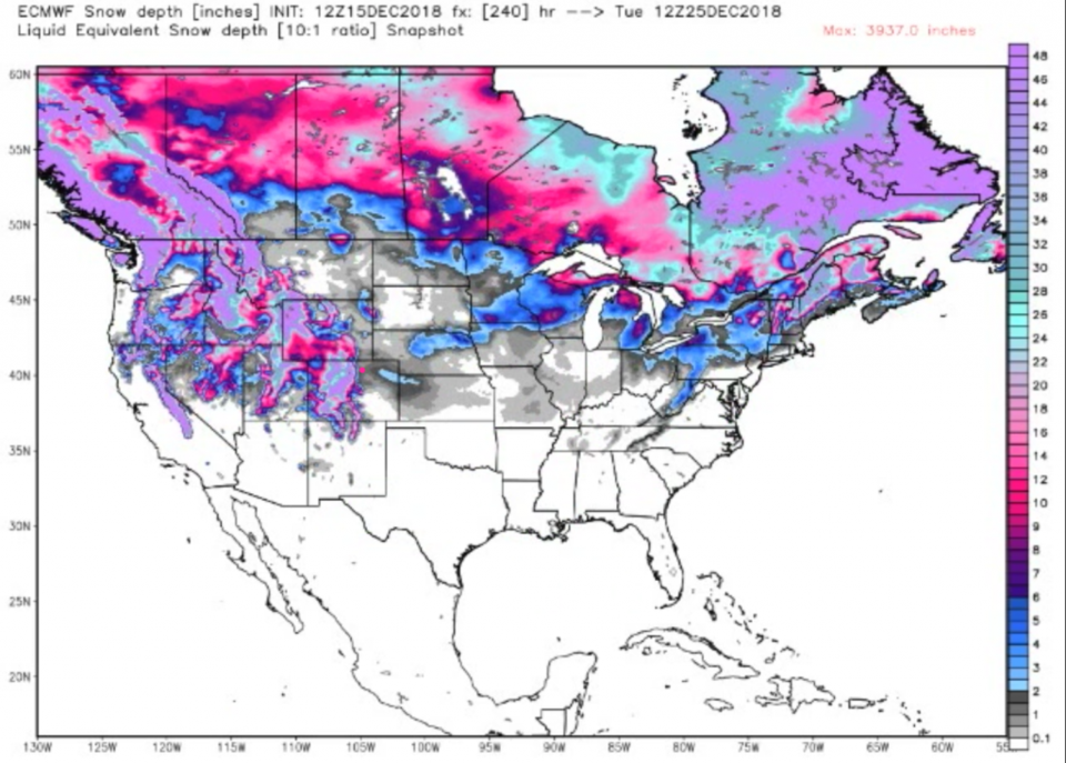
The GFS (Figure 4) has snow down to Lyons and Boulder by Christmas Day with more snow down to Loveland north of us. From the ECMWF model (Figure 5) we get, not the snowfall between now and then, but the forecast of snow on the ground for Christmas Day. We are in the 1/2 to 1 inch area with good mountain snows and even a stripe east of us off into Kansas. You can also check this map to see where friends around the country may see snow. There aren't many locations due to all the warmth this week over much of the nation.

Figure 2: The 500mb forecast upper air analysis for Friday PM. Pink dot is Longmont. Red lines are troughs, blue lines are ridges.

Figure 3: the graphical forecast for the next 10 days forecast for Estes Park, CO from weatherunderground.com

Figure 4: The forecast accumulated snow map from the GFS and weather5280.com for Colorado, through Christmas Day.

Figure 5: The forecast actual snow on the ground map from the ECWMF model and weatherbell.com for Colorado, through Christmas Day.

Current Weather

Clear

Clear

61°F

UV Index
0 Low
Pressure
29.45 Falling
Visibility
8 miles
Dewpoint
32 °F
Humidity
33%
Wind
S 3.8 mph
Gust
9.1 mph
Wind Chill
61 °F

Hourly Forecast

Today
1 AM
57°F
Intermittent clouds
Today
2 AM
55°F
Mostly cloudy
Today
3 AM
54°F
Cloudy
Today
4 AM
52°F
Cloudy
Today
5 AM
50°F
Cloudy
Today
6 AM
49°F
Cloudy
Today
7 AM
47°F
Cloudy
Today
8 AM
48°F
Cloudy
Today
9 AM
50°F
Cloudy
Today
10 AM
51°F
Cloudy
Today
11 AM
52°F
Cloudy
Today
12 PM
52°F
Cloudy

7 Day Forecast

Intermittent clouds

Sunday

76 °F

Warmer with intervals of clouds and sunshine


Windy

Sunday Night

47 °F

Winds becoming strong; thickening clouds


Windy

Monday

56 °F

Winds gusting past 40 mph; cloudy and cooler


Intermittent clouds

Monday Night

42 °F

Partly cloudy


Partly sunny w/ showers

Tuesday

59 °F

A couple of showers in the morning; otherwise, windy and cool with times of clouds and sun


Partly cloudy

Tuesday Night

32 °F

Partly cloudy


Intermittent clouds

Wednesday

58 °F

Cool with times of clouds and sun


Intermittent clouds

Wednesday Night

38 °F

Partly cloudy


Intermittent clouds

Thursday

56 °F

Breezy and cool with sun and clouds


Intermittent clouds

Thursday Night

39 °F

Partly cloudy


Sunrise and Sunset

Sunrise
5:54 AM
Sunset
8:00 PM

Based on AccuWeather data