Skip to content

Next Storm/Next Snow Forecast Discussion from the Cherrywood Observatory – December 21, 2018

This content was originally published by the Longmont Observer and is licensed under a Creative Commons license.

Forecast Discussion:

Welcome to the first day of Winter! It begins at 3:23 p.m. MT today when the sun is at its lowest point in the sky. Days are at about their shortest now, nights at about their longest.

Today's discussion is really an update to yesterday's as we wait for the first trough to bring us some Saturday a.m. and another round of p.m. snow. We'll hit near record heat (low 60's F) today - the record of 66° F set in 2003 is probably not in danger.

It is clear and beautiful for one more day today (Figure 1) - but you can see the front approaching from the northwest. It is knocking on Colorado's door.

You'll see below that this front will drop inches of snow in the mountains again, and spreads a trace to a coating across the Plains (and Longmont) Saturday a.m. and again p.m.

Figure 1: The forecast surface map for Friday PM. From NCEP.

The longer range forecast:

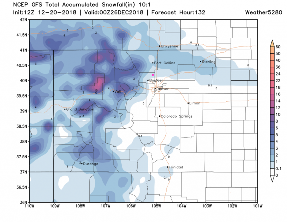
This first front will cool us down a lot. (How could we not cool down? What goes up must come down.) The GFS (Figure 2) spreads 1/10th inch to 1 inch of snow out across the northern I-25 corridor.

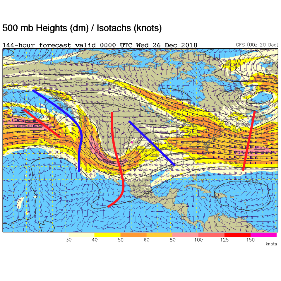
For Christmas, the next big trough is rolling towards us (Figure 3). It is looking pretty strong and is expected to dig deep into the desert southwest. This should bring in some snow later on Christmas Day though it is looking less significant than it did yesterday.

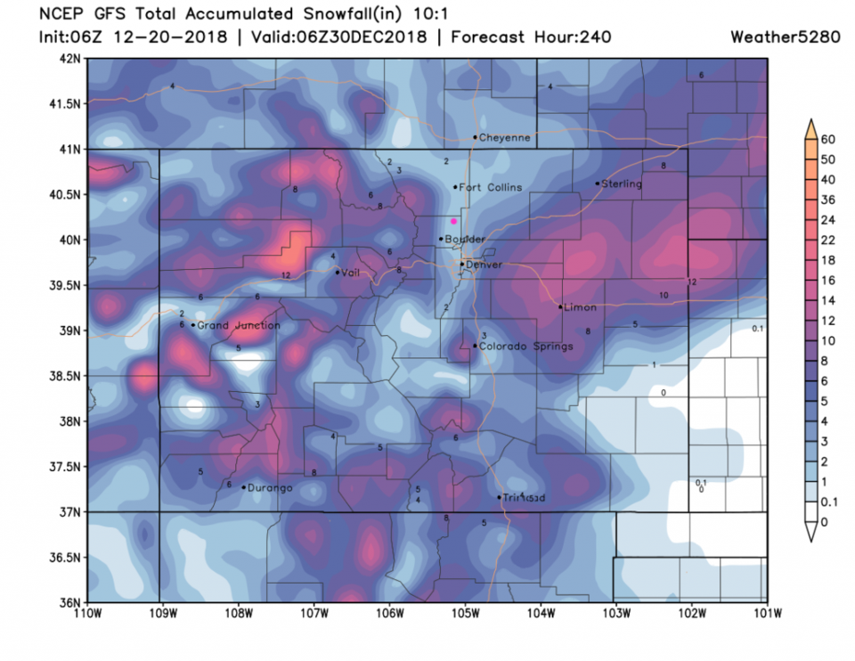
Figure 4 is the GEM's idea, and it is very similar to the GFS snowfall idea through Christmas night. More of a trace to maybe an inch, rather than inches of snow.

Still... there is a major change coming with colder temperatures every day for a while and more snow. The next 10 days sees Longmont receive 1-2 inches of snow while the mountains and plains may see up to a foot plus in places. If WeatherBell forecasters are correct, this is the start of a very cold and stormy couple of months (January/February) (overall). More later!

Figure 2: The forecast accumulated snow map from the GFS and weather5280.com for Colorado, through Christmas Eve morning.

Figure 3: The 500mb forecast upper air analysis for Christmas Day evening. Pink dot is Longmont. Red lines are troughs, blue lines are ridges.

Figure 4: The forecast accumulated snow map from the GFS and weather5280.com for Colorado, through Christmas Day night.

Figure 5: The forecast accumulated snow map from the GEM and tropicaltidbits.com for Colorado, through Christmas Day night.

Figure 6: The forecast accumulated snow map from the GFS and weather5280.com for Colorado, through the next 10 days.

Current Weather

Mostly cloudy

Mostly cloudy

60°F

UV Index
4 Moderate
Pressure
29.88 Steady
Visibility
8 miles
Dewpoint
42 °F
Humidity
51%
Wind
SSE 2.8 mph
Gust
7.3 mph
Wind Chill
60 °F

Hourly Forecast

Today
3 PM
60°F
Thunderstorms
Today
4 PM
61°F
Mostly cloudy
Today
5 PM
62°F
Mostly cloudy
Today
6 PM
60°F
Mostly cloudy
Today
7 PM
58°F
Intermittent clouds
Today
8 PM
55°F
Intermittent clouds
Today
9 PM
52°F
Intermittent clouds
Today
10 PM
49°F
Intermittent clouds
Today
11 PM
46°F
Intermittent clouds
Tomorrow
12 AM
45°F
Partly cloudy
Tomorrow
1 AM
43°F
Partly cloudy
Tomorrow
2 AM
42°F
Partly cloudy

7 Day Forecast

Partly sunny w/ t-storms

Sunday

62 °F

Warmer with times of clouds and sun; a thundershower in spots this afternoon


Intermittent clouds

Sunday Night

38 °F

Partly cloudy


Partly sunny

Monday

70 °F

Partly sunny, pleasant and warmer


Intermittent clouds

Monday Night

44 °F

Partly cloudy


Mostly sunny

Tuesday

73 °F

Mostly sunny and pleasant


Intermittent clouds

Tuesday Night

41 °F

Clearing


Intermittent clouds

Wednesday

65 °F

Times of sun and clouds


Intermittent clouds

Wednesday Night

39 °F

A thundershower in spots in the evening; otherwise, partly cloudy


Rain

Thursday

56 °F

Cooler with occasional rain and drizzle; breezy in the morning


Partly cloudy

Thursday Night

32 °F

Partly cloudy


Sunrise and Sunset

Sunrise
6:03 AM
Sunset
7:53 PM

Based on AccuWeather data