Skip to content

Next Storm/Next Snow Forecast Discussion from the Cherrywood Observatory – December 25, 2018

This content was originally published by the Longmont Observer and is licensed under a Creative Commons license.

Forecast Discussion:

Merry Christmas (to those who are reading online news today... I'll post this a bit early on Christmas Eve night for those putting bicycles together...)

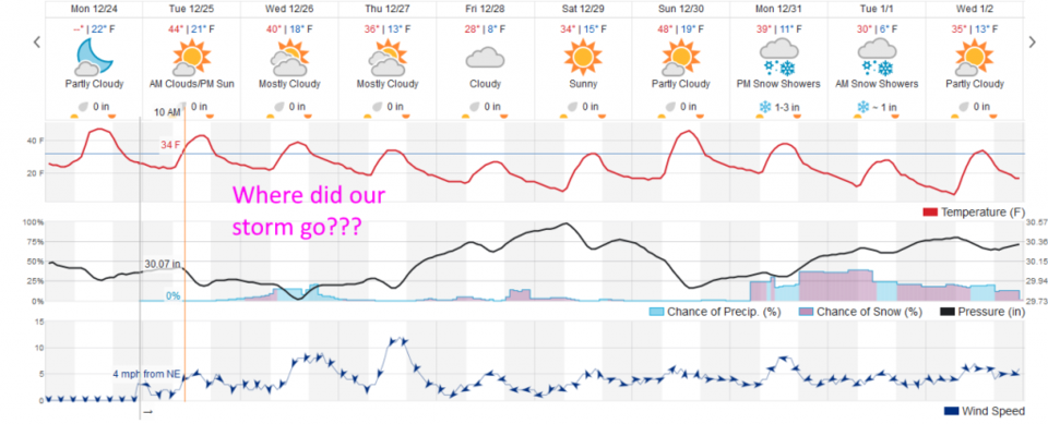
There will be light snow falling in the western slopes of our state and a few spots way out on the Plains, but things should be dry around Longmont (we do have 2% chance of blow-over flurries Christmas morning) (Figure 1).  We do climb to the mid-40'sF again today (a bit above average).

Figure 1: The forecast accumulated snow map from the GFS and weather5280.com for Colorado, through Christmas Day night.

The longer range forecast:

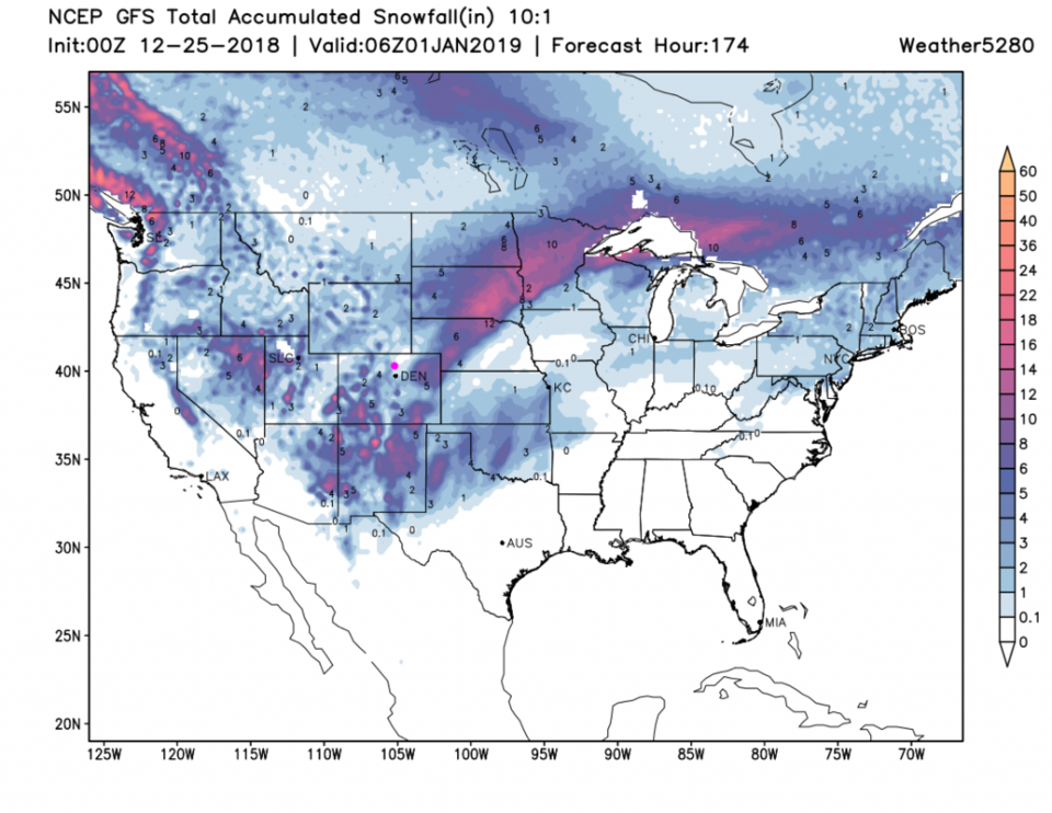
The models are trending the storm further south leaving us out of the snow-fun. Figure 2 shows meager chances of snow late Christmas night through Thursday AM.  That is, at least, good for holiday travel.

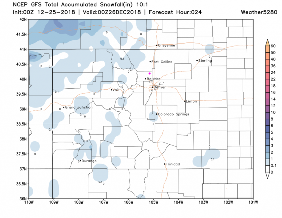
Looking out further, Figure 2 shows snow around the New Year period, but we've seen big storms 8-10 days out fade away before in this season.  It sure could happen again.  This is weatherunderground's model, the GFS (Figure 3) has good snows down in AZ, NM, TX and southern CO - Longmont is skipped, for the most part, through the start of 2019.  Hmmm.

Figure 2: the graphical forecast for the next 10 days forecast for Longmont, CO from weatherunderground.com

Figure 3: The forecast accumulated snow map from the GFS and weather5280.com for the entire CONUS, through New Years Day midnight.

Current Weather

Light rain

Light rain

42°F

UV Index
0 Low
Pressure
29.91 Steady
Visibility
7 miles
Dewpoint
39 °F
Humidity
91%
Wind
N 4 mph
Gust
8.5 mph
Wind Chill
40 °F

Hourly Forecast

Today
6 PM
42°F
Rain and snow
Today
7 PM
41°F
Rain and snow
Today
8 PM
42°F
Rain
Today
9 PM
42°F
Showers
Today
10 PM
41°F
Rain
Today
11 PM
41°F
Rain
Tomorrow
12 AM
41°F
Rain
Tomorrow
1 AM
40°F
Rain
Tomorrow
2 AM
39°F
Rain
Tomorrow
3 AM
39°F
Rain
Tomorrow
4 AM
38°F
Cloudy
Tomorrow
5 AM
37°F
Cloudy

7 Day Forecast

Rain and snow

Saturday

43 °F

Chilly with a mix of snow and rain; travel in the foothills and mountains will be slippery due to snow


Rain and snow

Saturday Night

37 °F

Cloudy with rain, mixed with a little snow late; travel in the foothills and mountains will be slippery due to snow


Thunderstorms

Sunday

61 °F

Mostly cloudy and warmer; a thundershower in spots in the afternoon


Partly cloudy w/ t-storms

Sunday Night

37 °F

A thunderstorm in spots in the evening; otherwise, partly cloudy


Partly sunny

Monday

71 °F

Partly sunny, pleasant and warmer


Intermittent clouds

Monday Night

42 °F

Partly cloudy


Mostly sunny

Tuesday

73 °F

Mostly sunny and pleasant


Mostly cloudy

Tuesday Night

43 °F

Mostly cloudy


Intermittent clouds

Wednesday

65 °F

Times of sun and clouds with a passing shower in the afternoon


Rain

Wednesday Night

42 °F

Mainly clear


Sunrise and Sunset

Sunrise
6:04 AM
Sunset
7:52 PM

Based on AccuWeather data