Skip to content

Update 9:30pm 10/6 Next Storm/Next Snow Forecast Discussion from the Cherrywood Observatory – December 5-7, 2019

This content was originally published by the Longmont Observer and is licensed under a Creative Commons license.

In Brief:

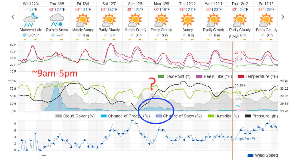
Our next storm is moving in with temperatures just at freezing at storm start rising to 40F during the height of the precipitation. Again, not a good recipe for a snow storm. Snow (and rain) could start as early as 6am, but will really get underway from 9am to 5pm. We have dry weather and warming temperatures through Saturday then another weather-fly my get in our ointment.

Update 9:30pm 10/6:

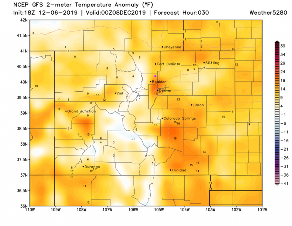
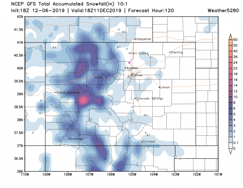
My rain gauge in NE Longmont received 1/10th of an inch of rain. I didn't see any snow fall (even at the end of yesterday's event). Now we warm up for a Christmas-light-hanging nice Saturday with temperatures 10-15F above normal (Figure 2 update). Our Sunday to Monday 'storm' is also very minor with temperatures looking too warm for snow. The GFS doesn't put down any snow in town (Figure 3 update). More tomorrow!

Figure 2 update: the surface temperature anomaly (departure from normal) from the GFS for Saturday evening from weather5280.com.
Figure 3 update: 10:1 (snow to liquid) snowfall totals through through Wednesday noon from the GFS and weather5280com for Colorado made Wednesday afternoon.

End Update 9:30pm 10/6.

Update 10am 12/5:

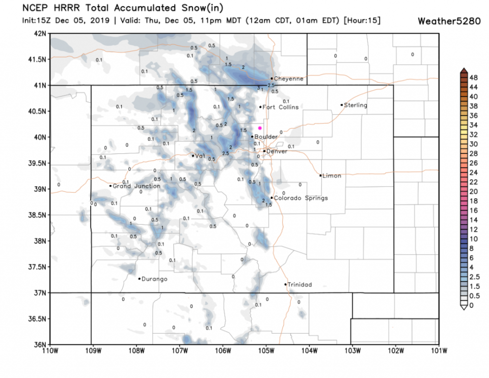
A quick update- as showers are falling... the HRRR model (it updates every hour) doesn't show measurable snow in Longmont (Figure 1 update). We do get between 1/10th of an inch of rain to maybe 1/4th in inch though (Figure 2 udpate). The thinking seems to be that, due to the dryness of the atmosphere at the lower levels, , the rain evaporating as it falls will cool the atmosphere enough for snow to fall in the later stages of the storm this afternoon. It all ends by 6-7pm. Other models still show maybe a coating to 1/2 inch of snow. Stay dray and watch out for that slippery snow/ice already on the ground.

Figure 1 update: The forecast snowfall for the next 15 hours from the HRRR and weather5280com for Colorado ma (up to 11pm Thursday) made Thursday at 9am.
Figure2 update: The forecast rainfall for the next 15 hours from the HRRR and weather5280com for Colorado (up to 11pm Thursday) made Thursday at 9am.

End Update 10am 12/5.

Forecast Discussion:

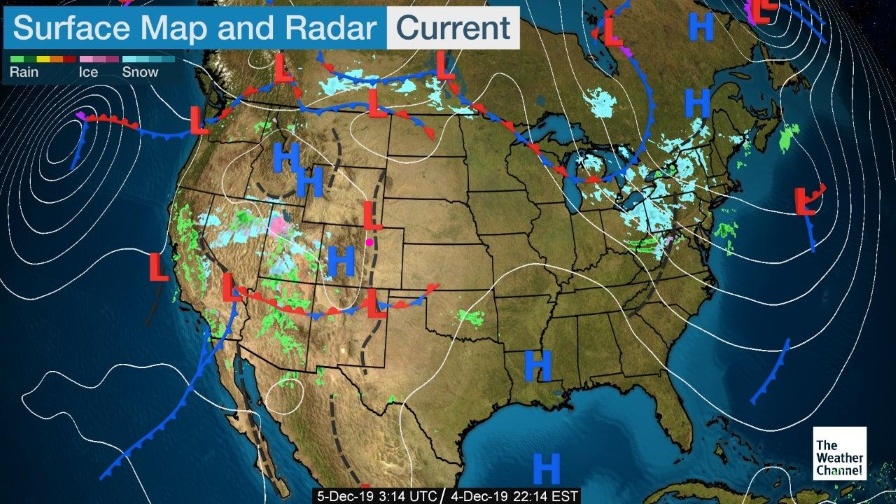
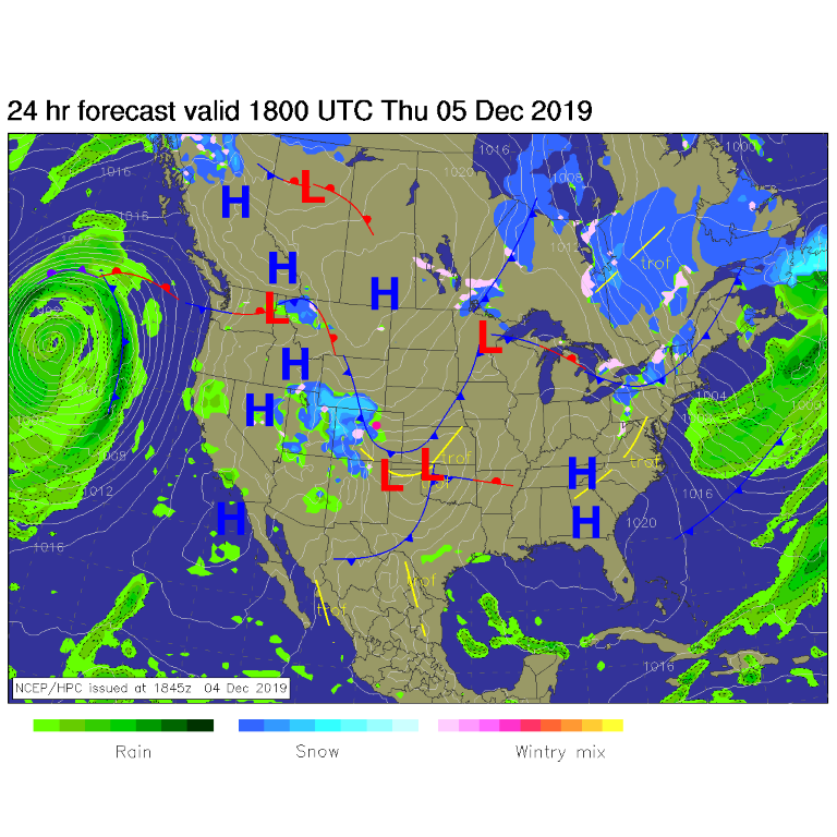
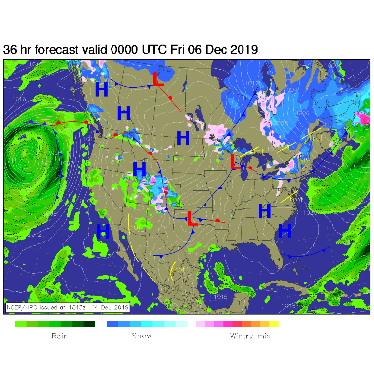
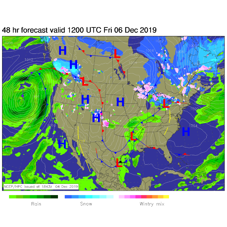
Late night Wednesday (Figure 1) our next storm is rolling through the desert southwest with high pressure departing Colorado. Moisture increases and a not-so-cold front slides over the state from the north to create cloudy skies and rain and snow (Figures 3, 4, 5). The best precipitation chances run from 9am - 5pm but could start between 5-6am and linger until 7-8pm (Figure 2). Most of the good snow hits the mountains to our west and distant southwest.

Snowfall Roundup:

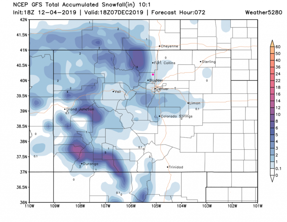
The GFS (Figure 6) does give us a coating to almost 1 inch of snow out of this storm (but will it stick anywhere but on the existing snow and ice?).
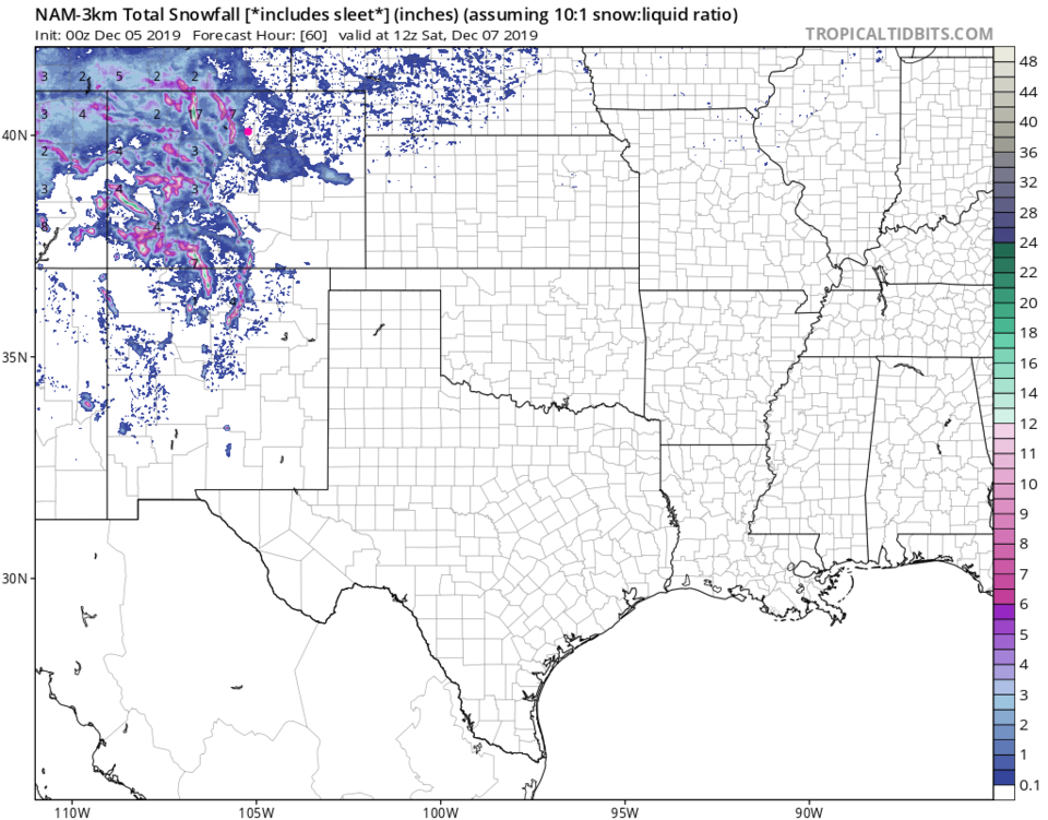
The NAM (Figure 7) keeps the snow to the slightly higher elevations west of most of Longmont.
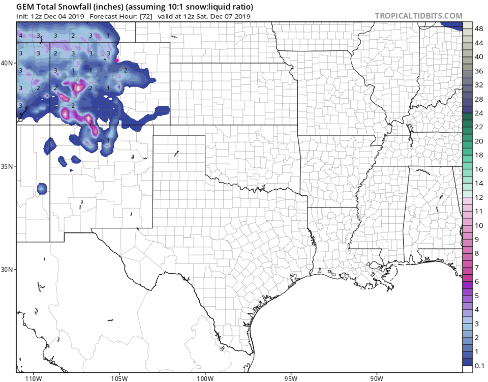
The GEM (Figure 8) maybe gives the west side a coating but only produces rain on the east side.
It does not look like you'll need to shovel this one.

The Longer Range Forecast:

We are mostly dry on Friday and warmer, then climb to the mid 50'sF Saturday (Figure 2). There is a Sunday-Monday system we'll need to watch, but one shouldn't get too excited about the next-next storm until the next storm is done.

Figure 1: the current surface analysis map from Wednesday PM and the weather channel.
Figure 2: the graphical forecast for the next 10 days for Longmont, CO from weatherunderground.com
Figure 3: The forecast surface map for Thursday noon from NCEP.
Figure 4: The forecast surface map for Thursday night from NCEP.
Figure 5: The forecast surface map for Friday morning from NCEP.
Figure 2: 10:1 (snow to liquid) snowfall totals through through Saturday noon from the GFS and weather5280com for Colorado made Wednesday afternoon.
Figure 7: 10:1 (snow to liquid) snowfall totals through Saturday noon from the NAM and tropicaltidbits. com for Colorado made Wednesday afternoon.
Figure 8: 10:1 (snow to liquid) snowfall totals through Saturday noon from the GEM and tropicaltidbits. com for Colorado made Wednesday afternoon.

Current Weather

Mostly cloudy

Mostly cloudy

59°F

UV Index
5 Moderate
Pressure
29.61 Rising
Visibility
8 miles
Dewpoint
24 °F
Humidity
26%
Wind
WSW 11.6 mph
Gust
23.1 mph
Wind Chill
59 °F

Hourly Forecast

Today
2 PM
60°F
Showers
Today
3 PM
62°F
Intermittent clouds
Today
4 PM
60°F
Intermittent clouds
Today
5 PM
58°F
Intermittent clouds
Today
6 PM
56°F
Intermittent clouds
Today
7 PM
54°F
Intermittent clouds
Today
8 PM
51°F
Intermittent clouds
Today
9 PM
48°F
Partly cloudy
Today
10 PM
45°F
Partly cloudy
Today
11 PM
43°F
Partly cloudy
Tomorrow
12 AM
42°F
Mostly clear
Tomorrow
1 AM
40°F
Mostly clear

7 Day Forecast

Partly sunny w/ showers

Tuesday

62 °F

Times of clouds and sun with a couple of brief showers beginning at midday; windy


Partly cloudy

Tuesday Night

34 °F

Partly cloudy and colder; there can be frost in the normally colder spots


Intermittent clouds

Wednesday

59 °F

Cool with times of clouds and sun


Mostly cloudy w/ showers

Wednesday Night

37 °F

Increasing clouds with a shower in spots late


Partly sunny w/ showers

Thursday

56 °F

Times of clouds and sun with a couple of showers; cool


Partly cloudy

Thursday Night

40 °F

Partly cloudy


Mostly cloudy

Friday

63 °F

Mostly cloudy and warmer


Clear

Friday Night

40 °F

Clear


Mostly sunny

Saturday

74 °F

Mostly sunny, pleasant and warmer


Mostly clear

Saturday Night

43 °F

Mainly clear


Sunrise and Sunset

Sunrise
5:52 AM
Sunset
8:02 PM

Based on AccuWeather data