Skip to content

Next Storm/Next Snow Forecast Discussion from the Cherrywood Observatory – December 7, 2018

This content was originally published by the Longmont Observer and is licensed under a Creative Commons license.

Forecast Discussion:

Yes we got the top amount of snow I forecasted... and it lasted longer than even the NWS guessed.  Figure 1 shows we approached or surpassed 1 inch of snow across most of the town.  With temperatures remaining in the upper 20'sF, the roads were icy/snowy for quite a while.

The the jet stream is far to the south (shown a few times this last week in these discussions) and a very juicy storm is rolling to the south and east of us along the Mexico border (Figure 2). We have a front in place and southwest winds moving in (looking like a warm front) but not much in precipitation.  We warm up for a few days now.

Figure 1: The CoCoRaHS water reports by Thursday 7am.

Figure 2: The forecast surface map for Friday night. From NCEP.

The longer range forecast:

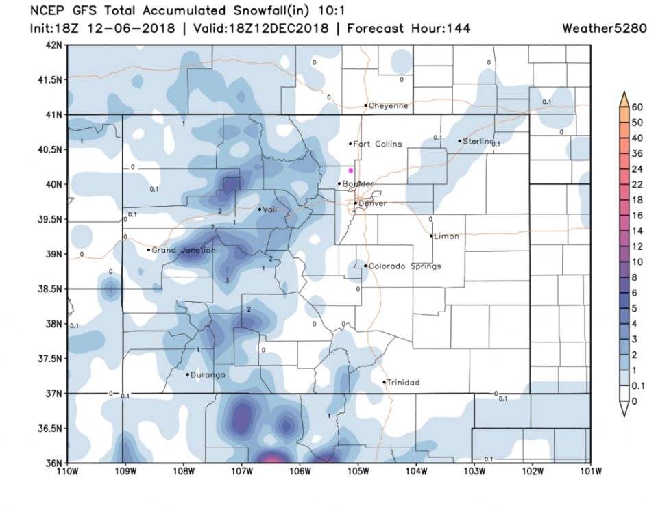
We warm almost to the 50'sF over the next 6 days before another front brings in colder air and a chance of snow (Figure 3).  Looking out 6 days (next Wednesday), the western and higher mountains get snow, but we don't see anything quite make it to Longmont (Figure 4).  With the next front coming in (circled  in blue) we do get a chance of snow around here.  Figure 5 gives us 1-2" day 6 and 7 from now (Wed - Fri AM).  It's not much to look forward to, but I'll take it.

Figure 3: 10 day meteogram from weather5280.com for DIA.

Figure 4: The forecast accumulated snow map from the GFS and weather5280.com for Colorado, through the next 6 days.

Figure 5: The forecast accumulated snow map from the GFS and weather5280.com for Colorado, through the next 10 days.

Current Weather

Mostly cloudy

Mostly cloudy

38°F

UV Index
0 Low
Pressure
29.96 Steady
Visibility
8 miles
Dewpoint
35 °F
Humidity
89%
Wind
WNW 1.8 mph
Gust
3.2 mph
Wind Chill
38 °F

Hourly Forecast

Today
6 AM
37°F
Partly cloudy
Today
7 AM
40°F
Partly sunny
Today
8 AM
48°F
Partly sunny
Today
9 AM
54°F
Partly sunny
Today
10 AM
58°F
Partly sunny
Today
11 AM
62°F
Partly sunny
Today
12 PM
65°F
Partly sunny
Today
1 PM
67°F
Partly sunny
Today
2 PM
68°F
Partly sunny
Today
3 PM
69°F
Partly sunny
Today
4 PM
70°F
Partly sunny
Today
5 PM
69°F
Partly sunny

7 Day Forecast

Partly sunny

Monday

70 °F

Partly sunny and pleasant


Intermittent clouds

Monday Night

43 °F

Partly cloudy


Mostly sunny

Tuesday

73 °F

Mostly sunny; windy in the morning, then pleasant in the afternoon


Intermittent clouds

Tuesday Night

43 °F

Clearing


Intermittent clouds

Wednesday

65 °F

Periods of clouds and sun; breezy in the afternoon


Intermittent clouds

Wednesday Night

39 °F

An evening thundershower in spots; otherwise, partly cloudy


Intermittent clouds

Thursday

57 °F

Clouds and sun, becoming windier and cooler with a shower in spots


Mostly clear

Thursday Night

32 °F

Mainly clear


Mostly sunny

Friday

71 °F

Mostly sunny, pleasant and warmer


Partly cloudy

Friday Night

36 °F

Partly cloudy


Sunrise and Sunset

Sunrise
6:02 AM
Sunset
7:54 PM

Based on AccuWeather data