Skip to content

Next Storm/Next Snow Forecast Discussion from the Cherrywood Observatory – February 17, 2019

This content was originally published by the Longmont Observer and is licensed under a Creative Commons license.

Forecast Discussion:

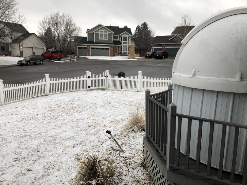
The first cold front hit and had a period of moist uplift after its passage significant enough to drop 1/2 inch of snow on my part of town (Figure 1). I didn't directly forecast that but did show maps hinting at some minimal snow amounts near Longmont. (This post will go up early since we are mid-storm and serious cold is coming soon.)

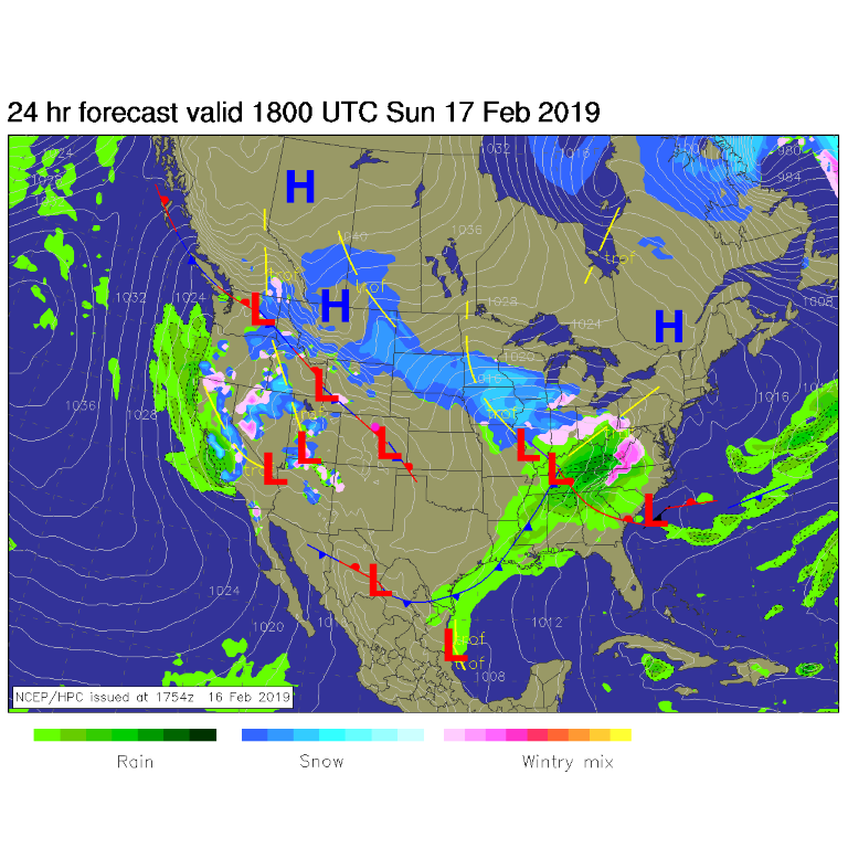
The cold fronts will keep coming, the temperatures will keep dropping, and snow will soon coat everything. A nice period of winter returns. For today (Sunday), we are briefly between surges of moisture from the Pacific and cold front passages. We start the day dry (Figure 2).

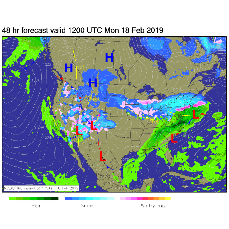
The next period of snow begins around 6 pm today (Sunday) with snow chances fairly continuous through midday Tuesday (Figure 3). Note that the high on Monday may only be in the teens and Tuesday not much better in the lower 20's F.

This is all what a giant trough in the west does with cold Canadian air flowing south over the ridge off in the eastern Pacific (Figure 4). Ripples in the flow will bring periods of instability over the area and surges of colder and colder air. By tomorrow morning (Monday am), figure 5 shows that snowfall will be spreading over much of the state.

The longer range forecast:

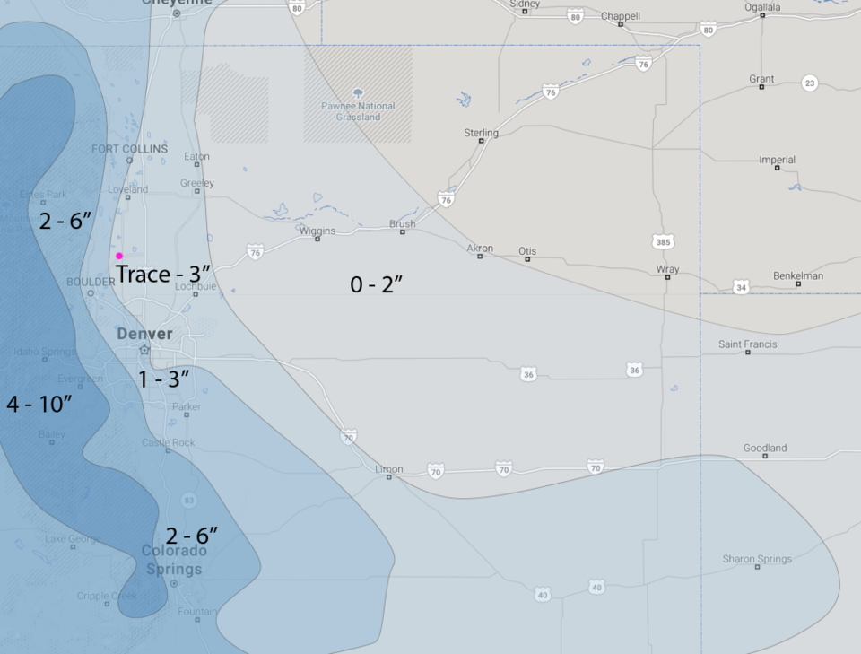
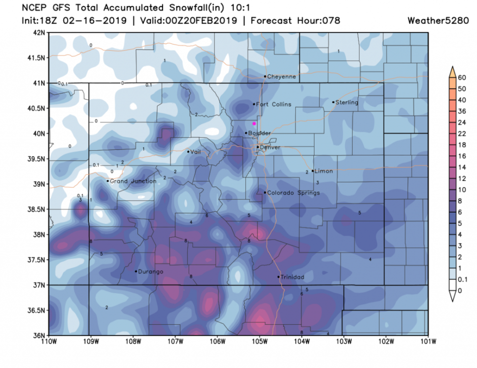
The weatherunderground model in Figure 3 gives us about 2-4 inches of snow through Monday pm. The forecasters at weather5280.com's hand-drawn forecast gives us a trace to three inches (Figure 6). The GFS paints us with 1/2 to 2 inches through Monday pm (Figure 7). By 24 hours later (Figure 8) the GFS gives us 2-3 inches of snow.

Looking back on Figure 3, we warm to the 30's F on Wednesday and see a late week return of snow. More on that after the current storm plays its hand.


Figure 1: picture by John Ensworth at the Cherrywood Observatory of the Saturday midday 1/2 of snow.
Figure 2: The forecast surface map for Saturday noon. From NCEP.
Figure 3: the graphical forecast for the next 10 days for Longmont, CO from weatherunderground.com
Figure 4: The 500mb forecast upper air analysis for Monday AM. Pink dot is Longmont. Red lines are troughs, blue lines are ridges.
Figure 5: The forecast surface map for Monday AM. From NCEP.
Figure 6: the hand drawn snowfall forecast from the forecasters at weather5280.com (highly recommend reading their info as well!!).
Figure 7: the forecast accumulated snow map from the GFS and weather5280.com for Colorado, through Monday PM.
Figure 8: the forecast accumulated snow map from the GFS and weather5280.com for Colorado, through Tuesday PM.

Current Weather

Mostly clear

Mostly clear

47°F

UV Index
0 Low
Pressure
29.96 Rising
Visibility
8 miles
Dewpoint
40 °F
Humidity
75%
Wind
NE 1.7 mph
Gust
4 mph
Wind Chill
47 °F

Hourly Forecast

Today
10 PM
47°F
Partly cloudy w/ showers
Today
11 PM
46°F
Intermittent clouds
Tomorrow
12 AM
44°F
Partly cloudy
Tomorrow
1 AM
43°F
Partly cloudy
Tomorrow
2 AM
42°F
Partly cloudy
Tomorrow
3 AM
41°F
Partly cloudy
Tomorrow
4 AM
39°F
Partly cloudy
Tomorrow
5 AM
38°F
Partly cloudy
Tomorrow
6 AM
37°F
Partly cloudy
Tomorrow
7 AM
40°F
Partly sunny
Tomorrow
8 AM
44°F
Mostly sunny
Tomorrow
9 AM
50°F
Mostly sunny

7 Day Forecast

Intermittent clouds

Sunday

64 °F

Warmer with times of clouds and sun


Partly cloudy w/ showers

Sunday Night

37 °F

A brief evening shower or two; otherwise, partly cloudy


Partly sunny

Monday

70 °F

Partly sunny and pleasant


Intermittent clouds

Monday Night

43 °F

Partly cloudy


Mostly sunny

Tuesday

73 °F

Mostly sunny and pleasant


Intermittent clouds

Tuesday Night

41 °F

Clearing


Intermittent clouds

Wednesday

65 °F

Times of sun and clouds


Intermittent clouds

Wednesday Night

39 °F

A thundershower in spots in the evening; otherwise, partly cloudy


Rain

Thursday

53 °F

Cooler with occasional rain and drizzle; breezy in the morning


Partly cloudy

Thursday Night

32 °F

Partly cloudy


Sunrise and Sunset

Sunrise
6:03 AM
Sunset
7:53 PM

Based on AccuWeather data