Skip to content

Next Storm/Next Snow Forecast Discussion from the Cherrywood Observatory – February 18, 2019

This content was originally published by the Longmont Observer and is licensed under a Creative Commons license.

Forecast Discussion:

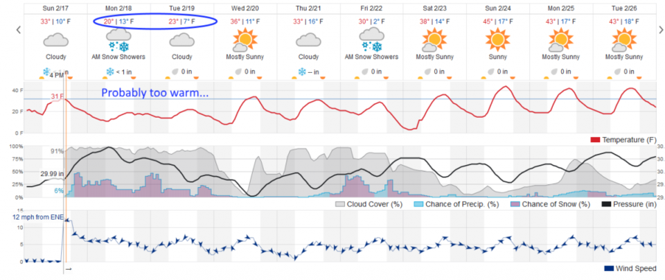
I'm publishing early as the storm is getting underway Sunday afternoon and will extend through the next 48+ hours. Snow is beginning to form in up-slope flow, up and down I-25 already. Figure 1 shows that snow will begin everywhere by 6 pm. There will be on and off light snow showers with dropping temperatures through Wednesday am.

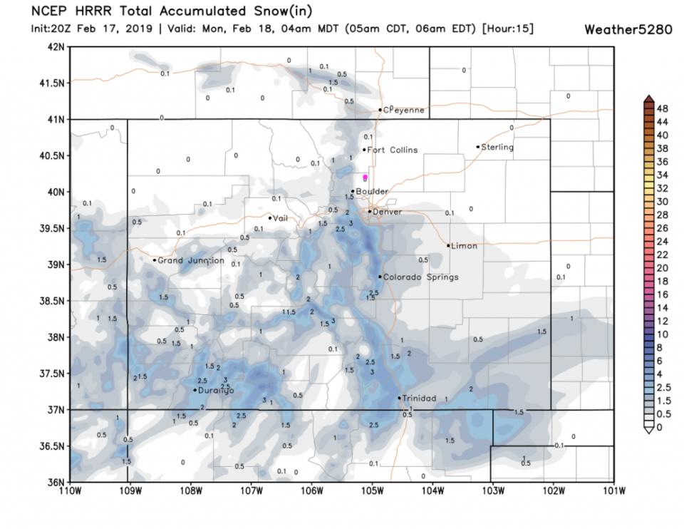
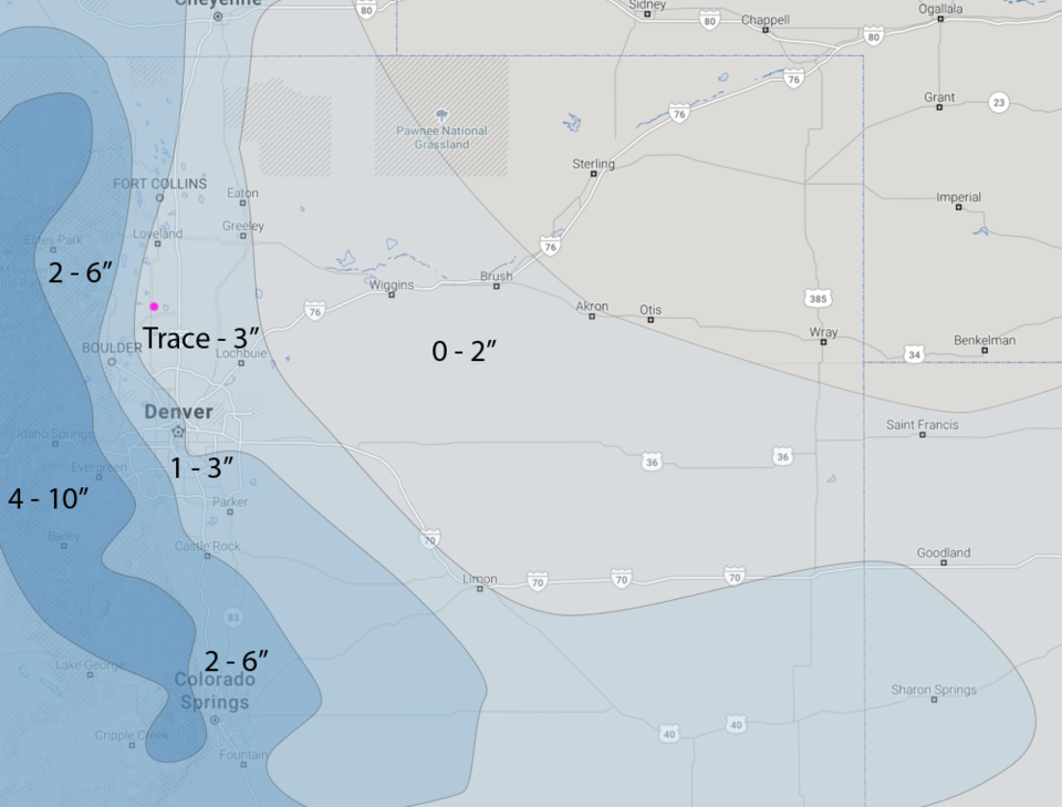
Figure 2, the HRRR, only has a trace to coating of snow by 4 am (so this won't be a massive snow storm in any way). Over the next 24 hours, the forecasters at weather5280.com give us a trace to 3 inches.

The longer range forecast:

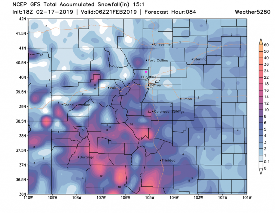
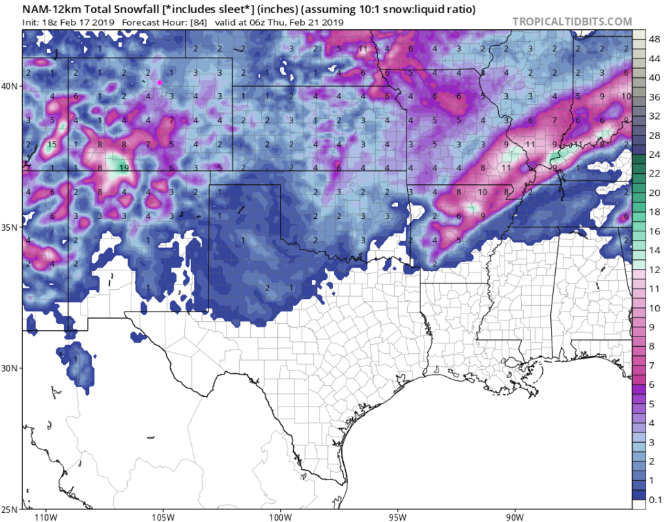
Going out to Wednesday pm the GFS (Figure 4) has us receiving 1-2 inches of snow. Note that snow ratios will be higher than 1:10 since temperatures will be so low. The snow will be fluffier and deeper for the same amount of water.

The NAM, for the same time period, has us receiving 2-3 inches (Figure 5). We stay chilly through Saturday with another system bringing snow in Friday. More on that later! Stay warm as highs sit in the teens Monday and Tuesday and lows drop to the single digits again.

Figure 1: the graphical forecast for the next 10 days for Longmont, CO from weatherunderground.com
Figure 2: the forecast accumulated snow map from the HRRR and weather5280.com for Colorado, through Monday 4am.
Figure 3: The hand drawn 24 hour snow forecast from the forecasters at weather5280.com published on the public post Sunday afternoon.
Figure 4: the forecast accumulated snow map from the GFS and weather5280.com for Colorado, through Wednesday late PM.
Figure 5: the forecast accumulated snow map from the NAM and tropicaltidbits.com for Colorado, through Wednesday late PM.

Current Weather

Mostly clear

Mostly clear

42°F

UV Index
0 Low
Pressure
29.71 Rising
Visibility
8 miles
Dewpoint
28 °F
Humidity
55%
Wind
W 3.2 mph
Gust
7.3 mph
Wind Chill
41 °F

Hourly Forecast

Today
10 PM
42°F
Partly cloudy
Today
11 PM
41°F
Partly cloudy
Tomorrow
12 AM
40°F
Mostly clear
Tomorrow
1 AM
39°F
Mostly clear
Tomorrow
2 AM
38°F
Mostly clear
Tomorrow
3 AM
37°F
Mostly clear
Tomorrow
4 AM
36°F
Mostly clear
Tomorrow
5 AM
36°F
Partly cloudy
Tomorrow
6 AM
35°F
Partly sunny
Tomorrow
7 AM
37°F
Intermittent clouds
Tomorrow
8 AM
41°F
Intermittent clouds
Tomorrow
9 AM
45°F
Intermittent clouds

7 Day Forecast

Partly sunny w/ showers

Tuesday

60 °F

Times of clouds and sun with a couple of brief showers beginning at midday; windy


Partly cloudy

Tuesday Night

35 °F

A shower in spots this evening; otherwise, partly cloudy and colder; there can be frost in the normally colder spots


Intermittent clouds

Wednesday

58 °F

Cool with times of clouds and sun


Mostly cloudy w/ showers

Wednesday Night

39 °F

Increasing clouds with a shower in spots late


Intermittent clouds

Thursday

56 °F

Cool with times of clouds and sun


Partly cloudy

Thursday Night

40 °F

Partly cloudy


Mostly cloudy

Friday

63 °F

Mostly cloudy and warmer


Clear

Friday Night

42 °F

Clear


Mostly sunny

Saturday

68 °F

Mostly sunny


Mostly clear

Saturday Night

43 °F

Mainly clear


Sunrise and Sunset

Sunrise
5:52 AM
Sunset
8:02 PM

Based on AccuWeather data