Skip to content

Next Storm/Next Snow Forecast Discussion from the Cherrywood Observatory – February 21, 2019

This content was originally published by the Longmont Observer and is licensed under a Creative Commons license.

Forecast discussion:

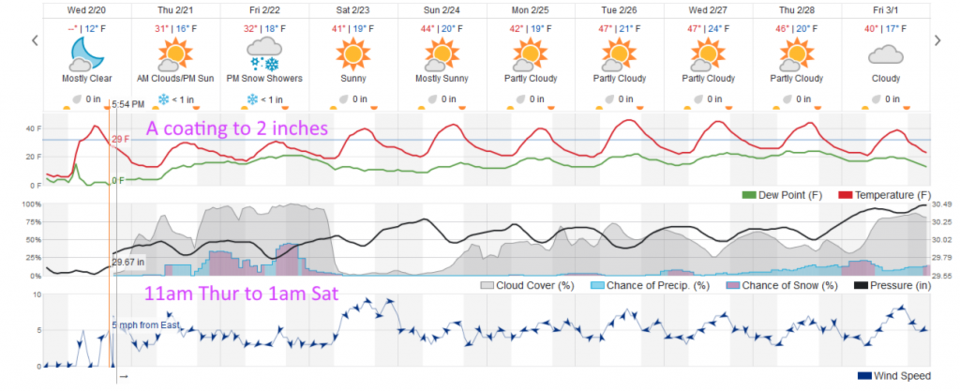
The winds of change, change again. The trough in the West gets reinforced with some new cold air. We cool from upper 30'sF to right around 30F (not THAT much of a drop). Precipitation chances start to increase midday and become more meaningful after midnight tonight (Figure 1).

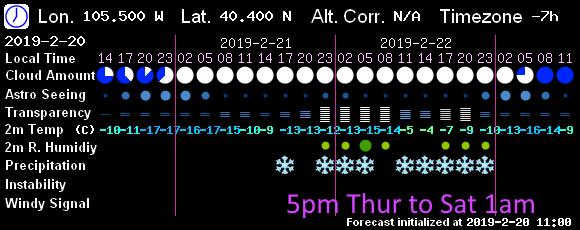
The 7! Timer model has the most likely period of snow running from 11pm to midnight Friday into Saturday (Figure 2).

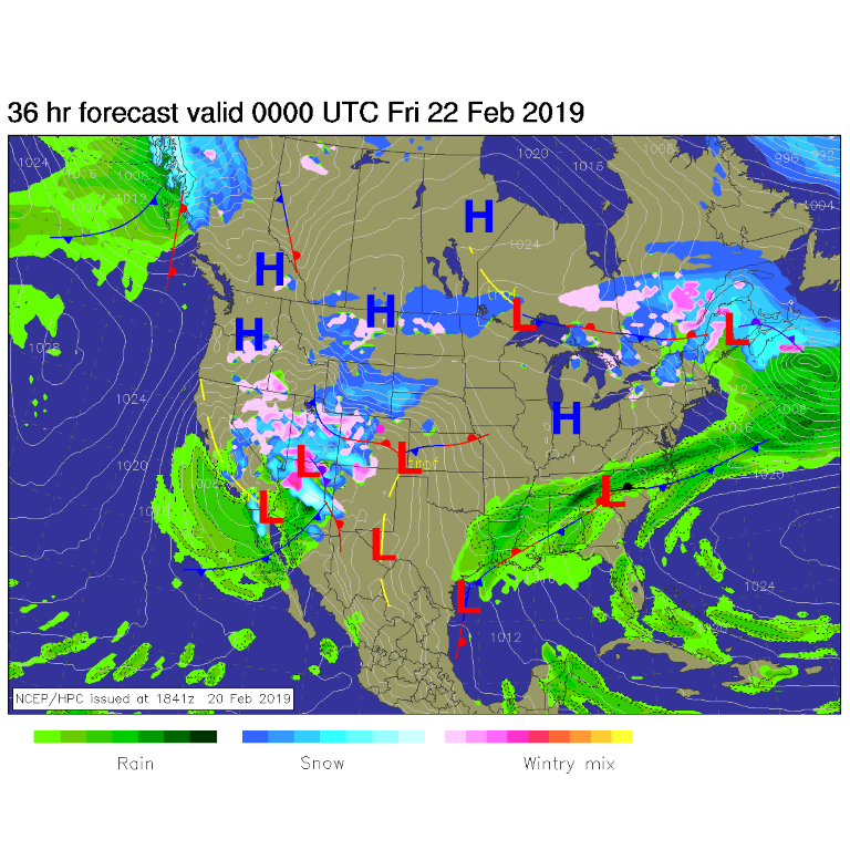
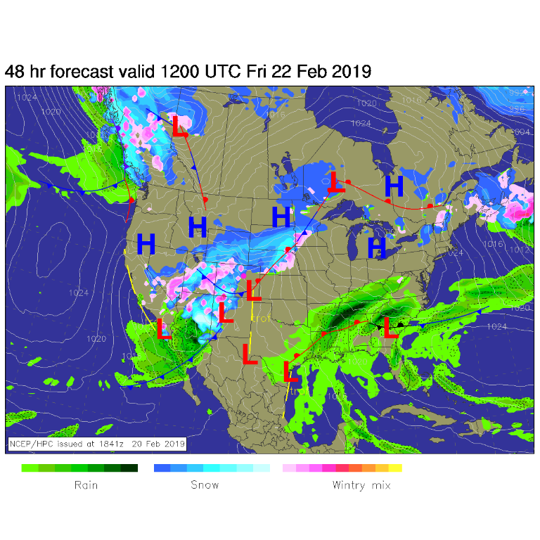
At the surface, this is another juicy storm that is moving into the desert southwest. Most of its moisture will be gone, again, by the time it gets over the continental divide (Figure 3 and 4).

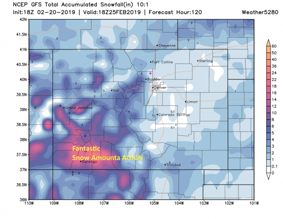
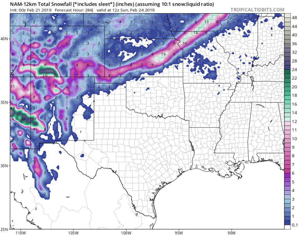
The GFS shows another foot to a foot and a half of snow piling up in the drought stricken southwestern mountains and a coating to 1 inch falling in Longmont by the end of the weekend (Figure 5). The NAM needs to be watched though, it drops about 4-6 inches in town (Figure 6) - that is an outlier. I'm not getting my big shovel out yet. Even weatherunderground (Figure 2 again) shows a coating to, maybe up to 2 inches out of this storm for us.

The longer range forecast:

We return to the 40'sF for the weekend with no big system on the horizon into next week. Not warm and not cold - we'll be close to normal temperature-wise.

Figure 1: the graphical forecast for the next 10 days for Longmont, CO from weatherunderground.com
Figure 2: 7Timer (GFS) forecast for sky conditions and precipitation type for the next 3 days for Longmont.
Figure 3: The forecast surface map for Thurs PM. From NCEP.
Figure 4: The forecast surface map for Friday AM From NCEP.
Figure 5: the forecast accumulated snow map from the GFS and weather5280.com for Colorado, through Monday noon.
Figure 6: the forecast accumulated snow map from the NAM and tropicaltidbits.com for Colorado, through Sunday AM.

Current Weather

Mostly cloudy

Mostly cloudy

60°F

UV Index
1 Low
Pressure
29.79 Steady
Visibility
8 miles
Dewpoint
38 °F
Humidity
43%
Wind
N 5.4 mph
Gust
11.1 mph
Wind Chill
60 °F

Hourly Forecast

Today
6 PM
58°F
Thunderstorms
Today
7 PM
56°F
Cloudy
Today
8 PM
55°F
Thunderstorms
Today
9 PM
53°F
Cloudy
Today
10 PM
50°F
Cloudy
Today
11 PM
48°F
Cloudy
Tomorrow
12 AM
46°F
Cloudy
Tomorrow
1 AM
44°F
Cloudy
Tomorrow
2 AM
42°F
Mostly cloudy
Tomorrow
3 AM
40°F
Mostly cloudy
Tomorrow
4 AM
38°F
Mostly cloudy
Tomorrow
5 AM
37°F
Mostly cloudy

7 Day Forecast

Mostly cloudy w/ t-storms

Wednesday

68 °F

Clouds and breaks of sun; a shower in spots this morning, then a couple of thunderstorms late this afternoon


Thunderstorms

Wednesday Night

35 °F

A thunderstorm this evening; otherwise, mostly cloudy


Intermittent clouds

Thursday

63 °F

A blend of sun and clouds


Mostly cloudy

Thursday Night

39 °F

Mostly cloudy


Partly sunny

Friday

64 °F

Some sun; breezy in the afternoon


Partly cloudy

Friday Night

36 °F

Partly cloudy


Partly sunny

Saturday

66 °F

Partial sunshine


Mostly clear

Saturday Night

41 °F

Clear to partly cloudy


Mostly cloudy

Sunday

78 °F

Rather cloudy and warmer; breezy in the afternoon


Mostly cloudy

Sunday Night

43 °F

Rather cloudy


Sunrise and Sunset

Sunrise
5:59 AM
Sunset
7:56 PM

Based on AccuWeather data