Skip to content

Next Storm/Next Snow Forecast Discussion from the Cherrywood Observatory – February 22, 2019

This content was originally published by the Longmont Observer and is licensed under a Creative Commons license.

Forecast Discussion: (Posted early as the next storm arrives tonight.)

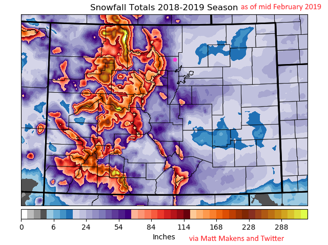
With one more foot (and locally up to 3 feet) of snow expected today through Saturday in the southwestern mountains of our state, this post by Matt M. on Twitter caught my eye. Figure 1 is the snowfall so far this season. The statewide snowfall total is at about 115% above normal.

Our new storm is already hitting the mountains but won't do much to the Plains until tonight. This system is powered by a deep, quickly moving, trough in the upper air flow (Figure 2, big red line).

A chance of showers sneaking off the mountains begins this afternoon, but snow showers will more likely start closer to midnight. There is another elevated chance of snow Friday afternoon into the night. This storm slips away Saturday morning (Figure 3).

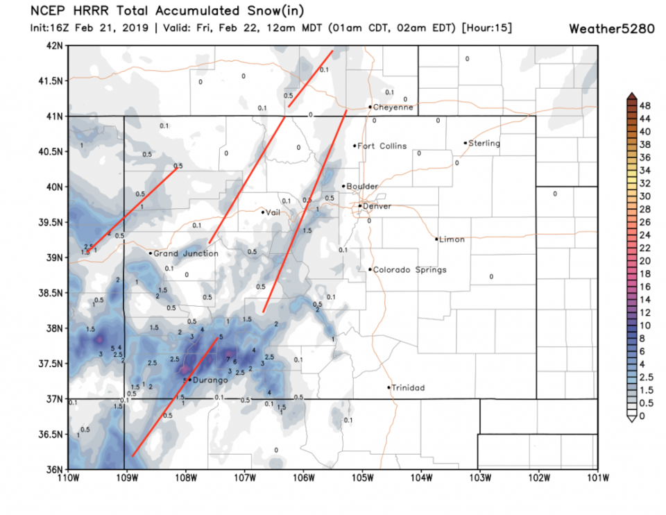
Through midnight, banded snow (yes, all the models show jet-driven banded snow will occur again) will be confined mainly to the mountains (the HRRR in Figure 4).

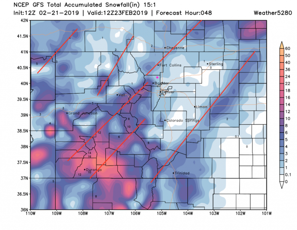
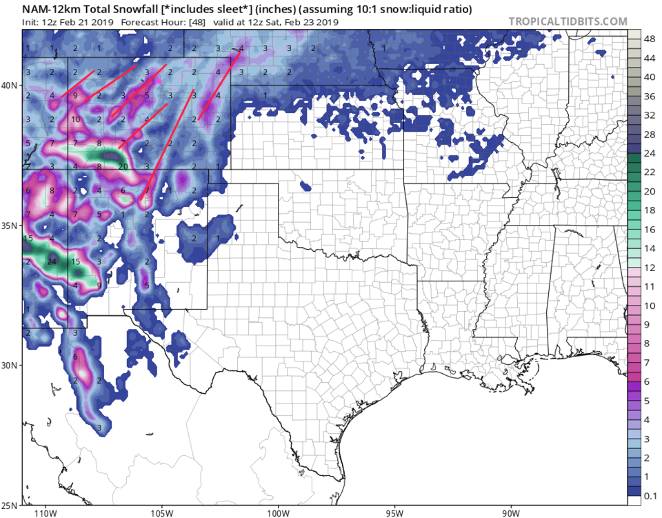
For the entire event, the GFS gives us about 1-2 inches of snow with a big band up to Boulder and into Boulder county. More could surprise us (Figure 5). The NAM (in Figure 6) shows the banding as well BUT puts us more under the 'Boulder county' band and gives us more like 3-5 inches (which is a consistent feature of this model from yesterday).

The longer range forecast:

After this snow, we warm to the upper 40'sF and lower 50'sF and have quiet weather through next week.

Figure 1: the snowfall so far this season for Colorado from Matt Makens via Twitter.
Figure 2: The 500mb forecast upper air analysis for Friday AM. Pink dot is Longmont. Red lines are troughs, blue lines are ridges.
Figure 3: the graphical forecast for the next 10 days for Longmont, CO from weatherunderground.com
Figure 4: the forecast accumulated snow map from the HRRR and weather5280.com for Colorado, through Thur/Fri midnight.
Figure 5: the forecast accumulated snow map from the GFS and weather5280.com for Colorado, through Saturday morning.
Figure 6: the forecast accumulated snow map from the NAM and tropicaltidbits.com for Colorado, through Saturday AM.

Current Weather

Mostly cloudy

Mostly cloudy

47°F

UV Index
0 Low
Pressure
29.96 Steady
Visibility
8 miles
Dewpoint
41 °F
Humidity
79%
Wind
SW 1.7 mph
Gust
4.6 mph
Wind Chill
47 °F

Hourly Forecast

Tomorrow
12 AM
44°F
Partly cloudy
Tomorrow
1 AM
43°F
Partly cloudy
Tomorrow
2 AM
42°F
Partly cloudy
Tomorrow
3 AM
41°F
Partly cloudy
Tomorrow
4 AM
39°F
Partly cloudy
Tomorrow
5 AM
38°F
Partly cloudy
Tomorrow
6 AM
37°F
Partly cloudy
Tomorrow
7 AM
40°F
Partly sunny
Tomorrow
8 AM
45°F
Mostly sunny
Tomorrow
9 AM
50°F
Mostly sunny
Tomorrow
10 AM
56°F
Partly sunny
Tomorrow
11 AM
59°F
Partly sunny

7 Day Forecast

Intermittent clouds

Sunday

64 °F

Warmer with times of clouds and sun


Partly cloudy w/ showers

Sunday Night

37 °F

A couple of brief showers late this evening; partly cloudy


Partly sunny

Monday

70 °F

Partly sunny and pleasant


Intermittent clouds

Monday Night

43 °F

Partly cloudy


Mostly sunny

Tuesday

73 °F

Mostly sunny and pleasant


Intermittent clouds

Tuesday Night

41 °F

Clearing


Intermittent clouds

Wednesday

65 °F

Times of sun and clouds


Intermittent clouds

Wednesday Night

39 °F

A thundershower in spots in the evening; otherwise, partly cloudy


Rain

Thursday

53 °F

Cooler with occasional rain and drizzle; breezy in the morning


Partly cloudy

Thursday Night

32 °F

Partly cloudy


Sunrise and Sunset

Sunrise
6:03 AM
Sunset
7:53 PM

Based on AccuWeather data