This content was originally published by the Longmont Observer and is licensed under a Creative Commons license.
Forecast Discussion:
UPDATE 1:30pm
The NWS has issued a: Winter Weather Advisory
Area included in alert: Larimer and Boulder Counties Between 6000 and 9000 Feet; Boulder And Jefferson Counties Below 6000 Feet/West Broomfield County; Central and East Adams and Arapahoe Counties; Elbert/Central and East Douglas Counties Above 6000 Feet; Central and South Weld County; Morgan County; Larimer County Below 6000 Feet/Northwest Weld County; Northeast Weld County; North Douglas County Below 6000 Feet/Denver/West Adams and Arapahoe Counties/East Broomfield County; Jefferson and West Douglas Counties Above 6000 Feet/Gilpin/Clear Creek/Northeast Park Counties Below 9000 Feet
Alert brief: Winter Weather Advisory issued February 22 at 10:20AM MST expiring February 23 at 8:00AM MST by NWS Denver CO
The next winter storm will make its way across the state this afternoon into Saturday. Mainly light snow is expected over the mountains this morning, but it is expected to increase in coverage and intensity this afternoon and evening. The heaviest snowfall amounts in the mountains are expected to be along and south of I-70 corridor. Moderate to heavy snow showers will develop over the urban corridor late this afternoon into this evening. The evening rush hour could have hazardous traveling conditions. Farther east, snow will begin this evening lasting through Saturday morning.
* WHAT...Snow expected. Total snow accumulations of 2 to 6 inches expected. Winds gusting as high as 30 mph.
* WHERE...Portions of central, north central and northeast Colorado.
* WHEN...From 4 PM this afternoon to 8 AM MST Saturday.
* ADDITIONAL DETAILS...Plan on slippery road conditions. The hazardous conditions could impact the evening commute.
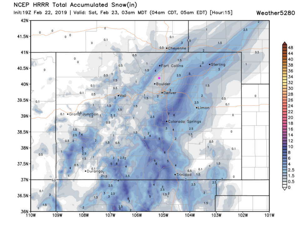
Figure 1 update shows the latest HRRR snowfall, now up to 3am Saturday. Longmont is in the 1 to 1.25 inch zone.
END 1:30PM UPDATE
We are between the small initial impulse that came in overnight (I received a dusting of snow in NE Longmont) and the main event coming in this afternoon. I'm posting Saturday's post early because of this...
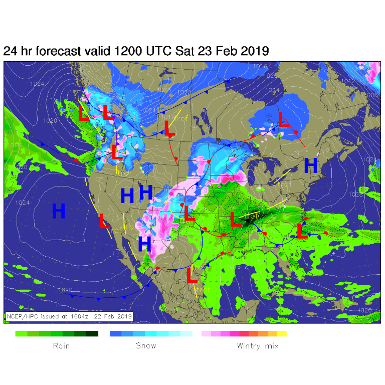
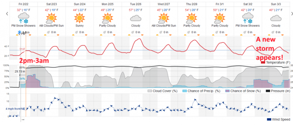
Figure 1 shows a big sloppy winter mess covering the state overnight Friday into Saturday am. Figure 2 shows the timing of the main snowfall: snow starts around 2-3 pm and tapers off after 3-4 am Saturday with some light snow or flurries possible into the early morning.
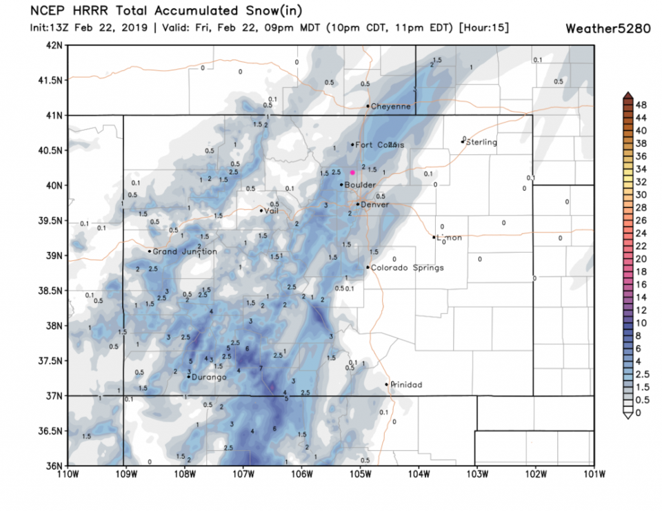
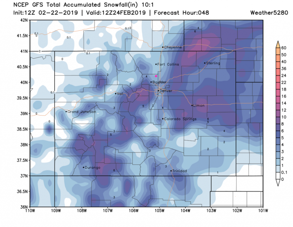
The high resolution model HRRR - Figure 3 - shows us getting about 1 to 1.5 inch by 9pm tonight (Friday). For the entire storm, we get 2-3 inches from the GFS (Figure 4) in Longmont with much heavier amounts just to our southwest and again to our east. Darn down-slope drying! Note, banding is still evident in the models and this situation with the jet stream dynamics overhead. Some neighborhoods might get surprised by 2-3X the regional average snowfall.
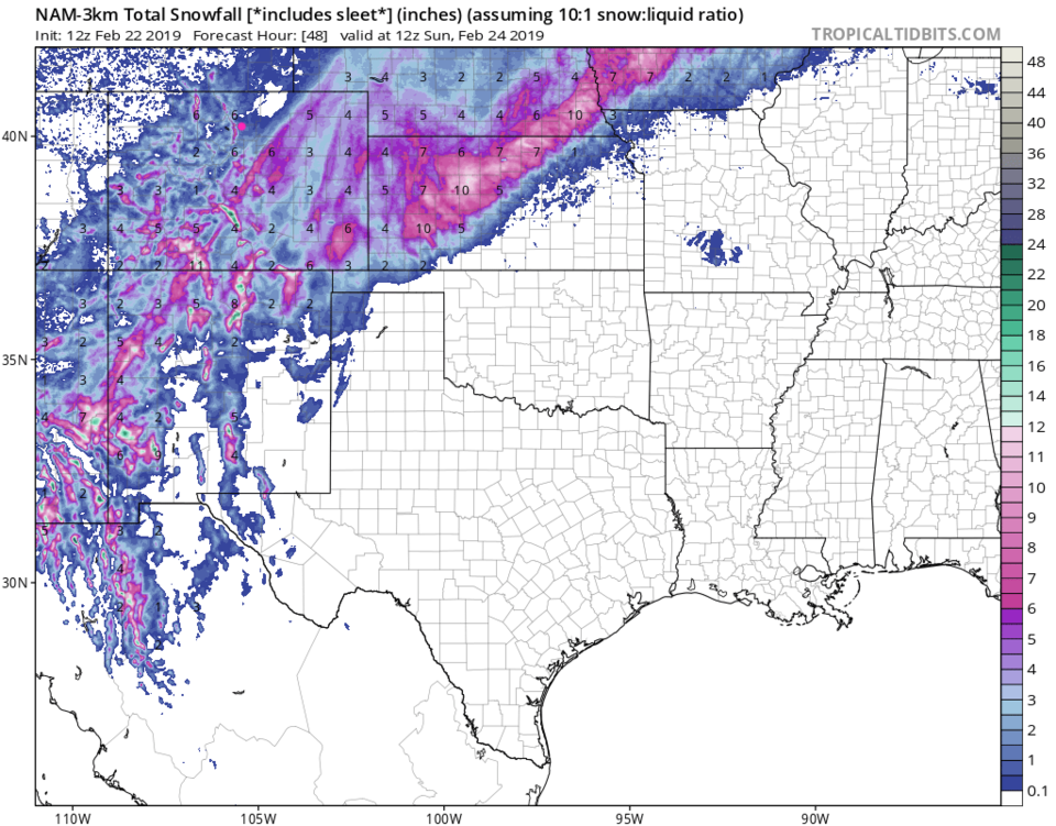
The higher resolution NAM also paints the 2-3 inch color near Longmont (Figure 5). It might be enough to shovel.
The longer range forecast:
We return to dry weather and upper 40's F for Sunday and then 50's F for mid- to late week. Another trough and cold front bring snow next weekend (what IS it with the weekends?! Figure 2 again).
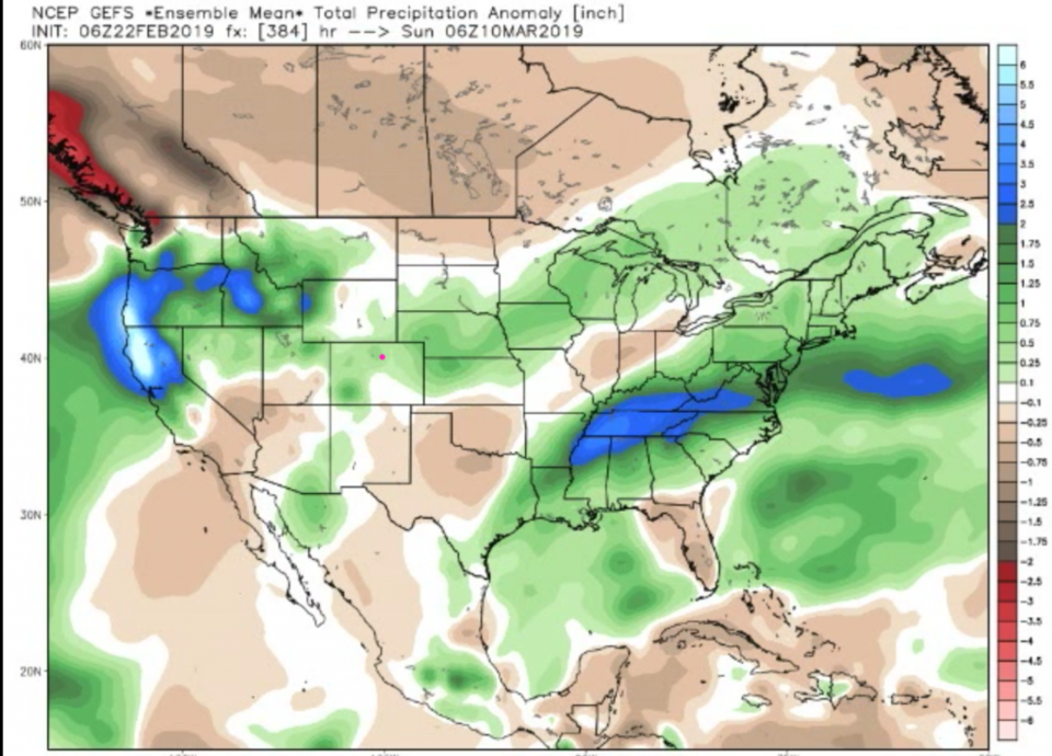
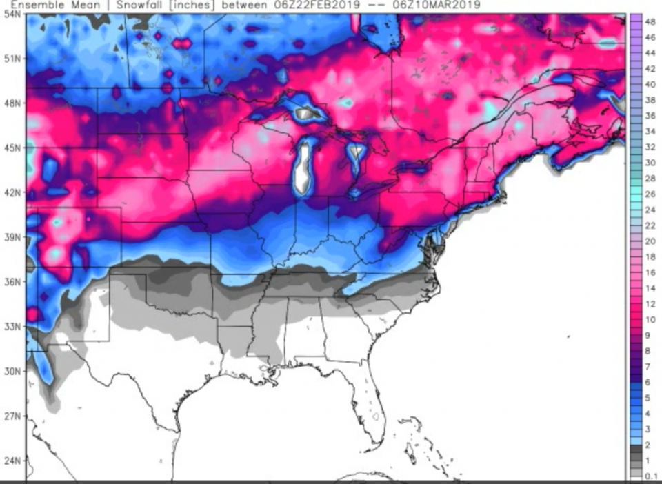
As a bonus, from weatherbell: they are calling for below normal temperatures through mid March, overall, for NE Colorado and above average precipitation (Figure 6). The cold-air-train from Canada is here to stay for a while. From this, they are pointing out a model snowfall total 6-7 inches for our neck of the woods through March 10th. We'll see!