Skip to content

Next Storm/Next Snow Forecast Discussion from the Cherrywood Observatory – February 24, 2019

This content was originally published by the Longmont Observer and is licensed under a Creative Commons license.

Forecast Discussion:

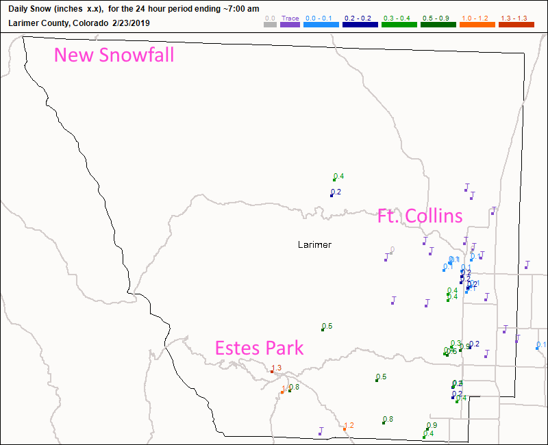
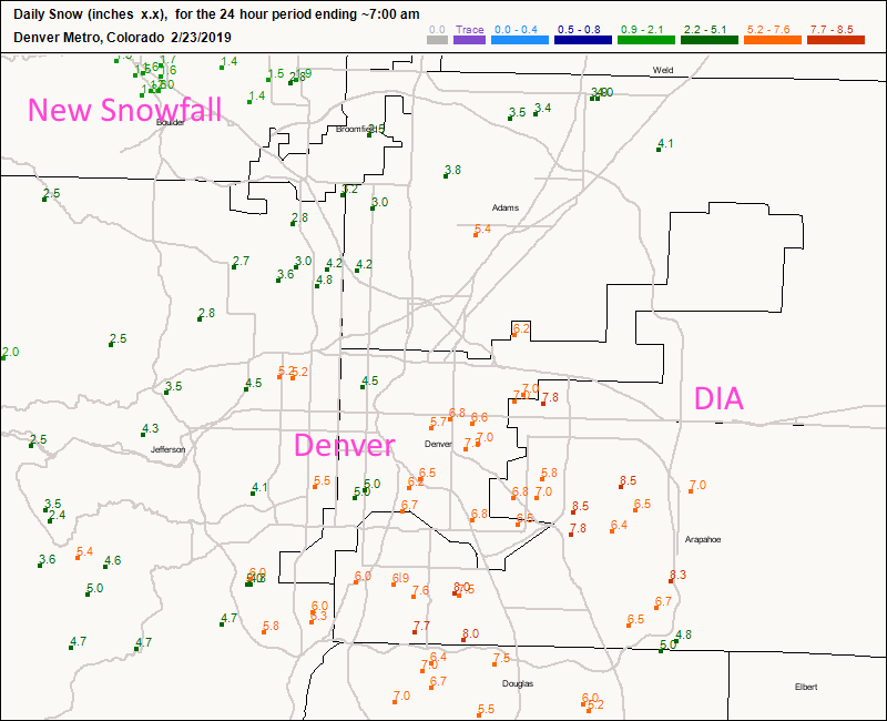
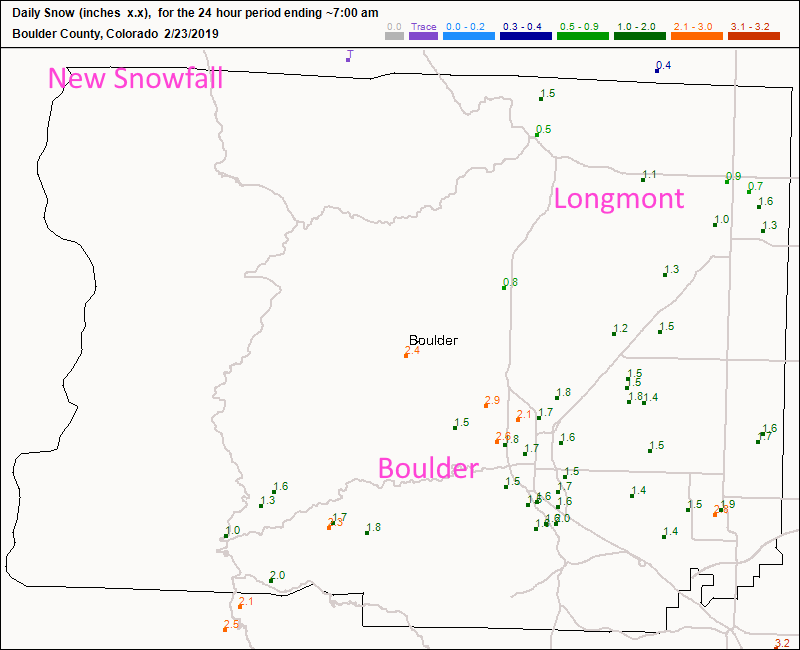
We had snow! Looking up and down the Front Range, Ft Collins (Figure 1) had a coating to 1/2 inch of snow. Estes Park only received 1-2 inches. Denver got hit by a snow band for a while and picked up 4-8 inches on the southern and eastern side of the city (Figure 2). Longmont received about 1 to 1.5 inches while Boulder received 1.5 to 3 inches (Figure 3).

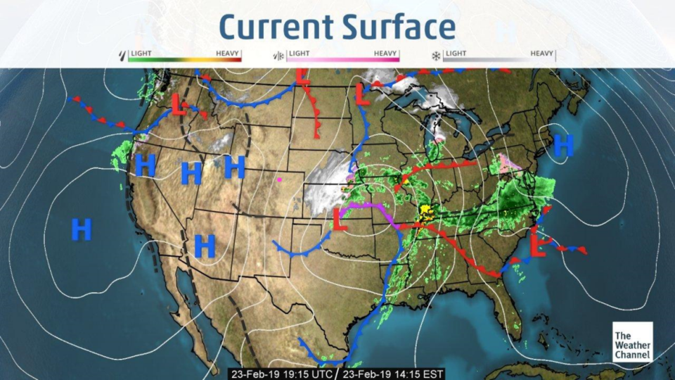
That storm is creating blizzard conditions in Kansas and Nebraska as it moves east leaving us dry and warming quickly (Figure 4).

The longer range forecast:

We stay 'warm' through the end of the month, then there is another temperature drop to below freezing highs after March starts with snow making a multi-day comeback (Figure 5). We'll keep an eye on it all together!

Figure 1: new Snow totals for Friday/Saturday up to 7am for Larimer county from CoCoRaHS.
Figure 2: new Snow totals for Friday/Saturday up to 7am for the Denver metro from CoCoRaHS.
Figure 3: new Snow totals for Friday/Saturday up to 7am for Boulder county from CoCoRaHS.
Figure 4: The current surface map from Saturday PM and the Weather Channel.
Figure 5: 10 day meteogram from weather5280.com for DIA.

Current Weather

Mostly sunny

Mostly sunny

53°F

UV Index
4 Moderate
Pressure
29.98 Falling
Visibility
8 miles
Dewpoint
37 °F
Humidity
54%
Wind
W 1.6 mph
Gust
4.6 mph
Wind Chill
53 °F

Hourly Forecast

Today
10 AM
58°F
Partly sunny
Today
11 AM
62°F
Partly sunny
Today
12 PM
64°F
Partly sunny
Today
1 PM
67°F
Partly sunny
Today
2 PM
68°F
Partly sunny
Today
3 PM
69°F
Partly sunny
Today
4 PM
70°F
Partly sunny
Today
5 PM
68°F
Partly sunny
Today
6 PM
67°F
Partly sunny
Today
7 PM
65°F
Partly sunny
Today
8 PM
61°F
Intermittent clouds
Today
9 PM
58°F
Intermittent clouds

7 Day Forecast

Partly sunny

Monday

70 °F

Partly sunny and pleasant


Intermittent clouds

Monday Night

44 °F

Partly cloudy


Mostly sunny

Tuesday

74 °F

Mostly sunny; windy in the morning, then pleasant in the afternoon


Intermittent clouds

Tuesday Night

44 °F

Clearing


Partly sunny w/ showers

Wednesday

65 °F

Periods of clouds and sun, becoming breezy with a passing shower in the afternoon


Mostly cloudy

Wednesday Night

39 °F

A thundershower in parts of the area in the evening; otherwise, mostly cloudy


Intermittent clouds

Thursday

57 °F

Windy in the morning; cooler with intervals of clouds and sun


Mostly clear

Thursday Night

32 °F

Mainly clear


Partly sunny

Friday

68 °F

Warmer with some sun


Partly cloudy

Friday Night

33 °F

Partly cloudy


Sunrise and Sunset

Sunrise
6:02 AM
Sunset
7:54 PM

Based on AccuWeather data