Skip to content

Update 2:30pm: Next Storm/Next Snow Forecast Discussion from the Cherrywood Observatory – January 12, 2019

This content was originally published by the Longmont Observer and is licensed under a Creative Commons license.

Forecast Discussion and Longer Range Forecast:

2:30pm Update:

Though temperatures remained above freezing and we didn't get much snow north of Denver, we did get good and welcome moisture.  Longmont got 1/3rd to 1/2 inch of water. Boulder received around 3/4th inch of water (Figure 1 update).  For snowfall, Longmont got a trace to around 1/2 inch (that was washed away by rainfall).  Boulder got about 1-4 inches of snow. The foothills to the west of Boulder received up to 9 inches (Figure 2 update)!

Denver saw 2-5 inches on the eastern side while the western foothills picked up 7-12 inches of snow (as did the Palmer Divide). Berthoud to Ft. Collins only saw a trace to 1/4th inch of snow.  Here's to hoping for more next time!

Figure 1 update: Boulder County water totals by Saturday 7am from CoCoRaHS.

Figure 1 update: Boulder County snowfall totals by Saturday 7am from CoCoRaHS.

End 2:30pm Update.

The storm is ending tonight.  I'll add precipitation reports here in the later afternoon once most of the reports are in.  Obviously, temperatures around Longmont to Ft. Collins were way too warm for anything more than snow in the air and a brief build up of almost 1 inch (that washed away with a return of the rain).

We needed the water though!

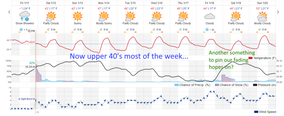
Figure 1 shows the storm ending rapidly Friday night.  Temperatures are not expected to get into the 50'sF this week now. Is that another storm next week that may matter???

More tomorrow!

Figure 1: the graphical forecast for the next 10 days forecast for Longmont, CO from weatherunderground.com

Current Weather

Mostly clear

Mostly clear

43°F

UV Index
0 Low
Pressure
29.97 Steady
Visibility
7 miles
Dewpoint
39 °F
Humidity
86%
Wind
WSW 1.7 mph
Gust
3.9 mph
Wind Chill
43 °F

Hourly Forecast

Today
2 AM
42°F
Partly cloudy
Today
3 AM
41°F
Partly cloudy
Today
4 AM
39°F
Partly cloudy
Today
5 AM
38°F
Partly cloudy
Today
6 AM
37°F
Partly cloudy
Today
7 AM
40°F
Partly sunny
Today
8 AM
45°F
Mostly sunny
Today
9 AM
50°F
Mostly sunny
Today
10 AM
56°F
Partly sunny
Today
11 AM
59°F
Partly sunny
Today
12 PM
62°F
Partly sunny
Today
1 PM
65°F
Partly sunny

7 Day Forecast

Intermittent clouds

Sunday

64 °F

Warmer with times of clouds and sun


Partly cloudy w/ showers

Sunday Night

37 °F

A couple of brief showers late this evening; partly cloudy


Partly sunny

Monday

70 °F

Partly sunny and pleasant


Intermittent clouds

Monday Night

43 °F

Partly cloudy


Mostly sunny

Tuesday

73 °F

Mostly sunny and pleasant


Intermittent clouds

Tuesday Night

41 °F

Clearing


Intermittent clouds

Wednesday

65 °F

Times of sun and clouds


Intermittent clouds

Wednesday Night

39 °F

A thundershower in spots in the evening; otherwise, partly cloudy


Rain

Thursday

53 °F

Cooler with occasional rain and drizzle; breezy in the morning


Partly cloudy

Thursday Night

32 °F

Partly cloudy


Sunrise and Sunset

Sunrise
6:03 AM
Sunset
7:53 PM

Based on AccuWeather data