Skip to content

Next Storm/Next Snow Forecast Discussion from the Cherrywood Observatory – January 14, 2019

This content was originally published by the Longmont Observer and is licensed under a Creative Commons license.

Forecast Discussion:

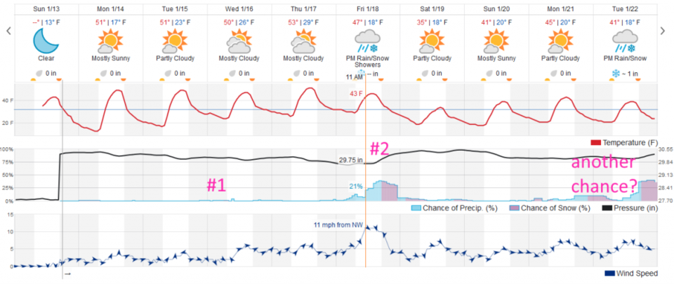
We are back in a quiet and above average (temperature) pattern with high pressure over the state (Figure 1). There isn't much to say about it except that a storm is again passing to our south (1) while the storm behind it (2) will crash into our western mountain slopes again by the end of the week.

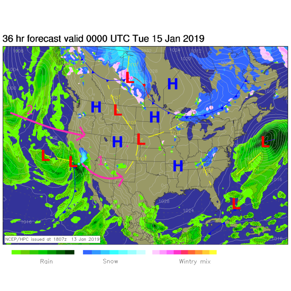
Figure 1: The forecast surface map for Monday PM. From NCEP.The longer range forecast:

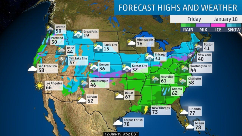
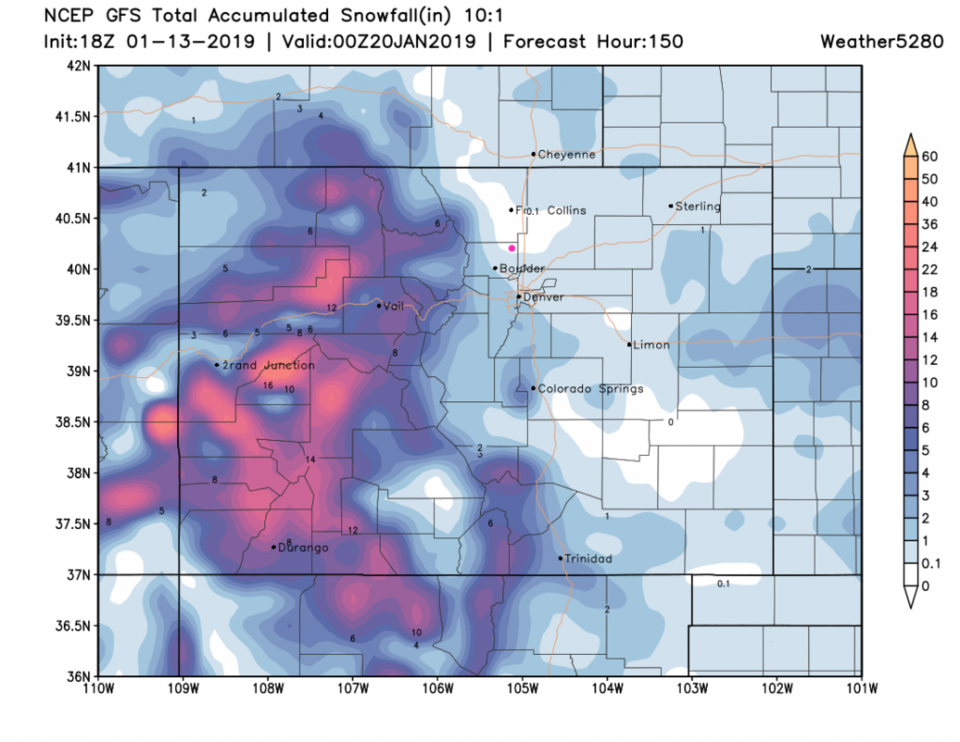
The storm (1 - Figure 2) passing to the south isn't a blip on the radar for us.  Storm 2 has a chance of giving us some snow Friday. There is another storm in the distant 10 day forecast, but let's not get excited THAT far out yet.   Figure 3 shows the widespread snow across the northern Rockies, western Colorado and Midwest with this storm and an arctic front headed out of Canada. Figure 4, the GFS, though, suggests that while the western slopes will see widespread 1-foot snow amounts, Longmont is in a hole of nothingness.  We'll keep watching it as the week goes on.  (I want snow!  *falls to ground and kicks feet having a fit...*)

Figure 2: the graphical forecast for the next 10 days forecast for Longmont, CO from weatherunderground.com

Figure 3: Forecast highs and precipitation type for the U.S. for Friday Jan 18th from the Weather Channel.

Figure 4: The forecast accumulated snow map from the GFS and weather5280.com for Colorado, for the next 6 days through Saturday PM.

Current Weather

Sunny

Sunny

73°F

UV Index
9 Very High
Pressure
29.78 Falling
Visibility
8 miles
Dewpoint
34 °F
Humidity
24%
Wind
SSE 4 mph
Gust
12.9 mph
Wind Chill
73 °F

Hourly Forecast

Today
1 PM
71°F
Partly sunny
Today
2 PM
72°F
Partly sunny
Today
3 PM
72°F
Partly sunny
Today
4 PM
69°F
Partly sunny
Today
5 PM
65°F
Partly sunny
Today
6 PM
60°F
Partly sunny
Today
7 PM
55°F
Partly sunny
Today
8 PM
52°F
Partly cloudy
Today
9 PM
49°F
Partly cloudy
Today
10 PM
47°F
Partly cloudy
Today
11 PM
44°F
Partly cloudy
Tomorrow
12 AM
43°F
Partly cloudy

7 Day Forecast

Mostly sunny

Friday

72 °F

Mostly sunny and pleasant; breezy this afternoon


Partly cloudy w/ showers

Friday Night

37 °F

Partly cloudy with a couple of showers late


Partly sunny

Saturday

66 °F

Sun and some clouds


Mostly clear

Saturday Night

40 °F

Clear to partly cloudy


Mostly cloudy

Sunday

76 °F

Mostly cloudy and warmer; breezy in the afternoon


Mostly cloudy

Sunday Night

51 °F

Rather cloudy; windy late


Windy

Monday

60 °F

Winds gusting past 40 mph; cloudy and cooler


Intermittent clouds

Monday Night

43 °F

Breezy in the evening; otherwise, partly cloudy


Intermittent clouds

Tuesday

62 °F

Times of clouds and sun; windy in the afternoon


Intermittent clouds

Tuesday Night

36 °F

Clearing


Sunrise and Sunset

Sunrise
5:57 AM
Sunset
7:58 PM

Based on AccuWeather data