Skip to content

Next Storm/Next Snow Forecast Discussion from the Cherrywood Observatory – January 5, 2019

This content was originally published by the Longmont Observer and is licensed under a Creative Commons license.

Forecast Discussion:

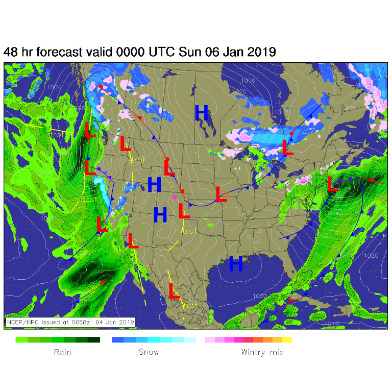
High pressure at the surface and a ridge aloft mean mild weather continues to rule. A juicy storm is impacting the West Coast of the U.S. (Figure 1), but that will spend itself by the time it reaches the western slopes of Colorado (we'll check on snow amounts in Figure 3).

Figure 1: The forecast surface map for Saturday PM. From NCEP.

The longer range forecast:

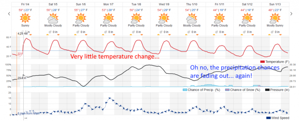
There might be a few sprinkles or snow flurries that make it over the mountains down onto the plains and I-25 Sunday night or Monday morning, but down slope flow warming will counter the cool front's cooling.  We just don't change much in temperature the next 10 days (Figure 2).

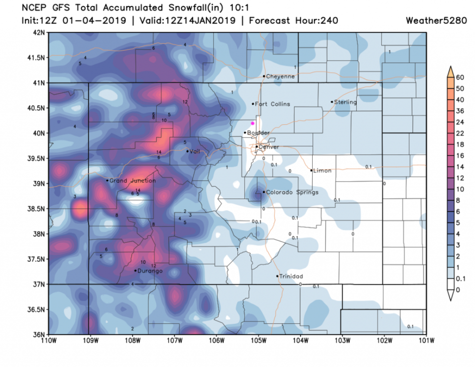
A check on the GFS and the next 10 days of snow for the state, things have dried out a lot in a couple of forecast days.  Figure 3 shows Longmont only getting a dusting to 1/2 inch of snow over the next two 'storms.'

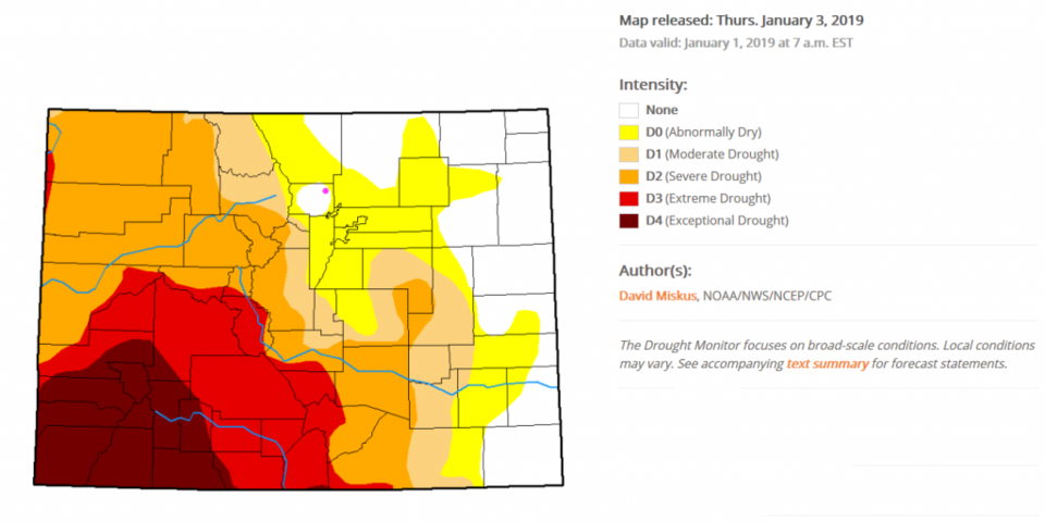
That creates a nice segue to checking on our state drought index map (Figure 4). The edges of boulder county are starting to see abnormally dry conditions.  The southwestern counties are still in extreme to exceptional drought conditions.  We need snow!!

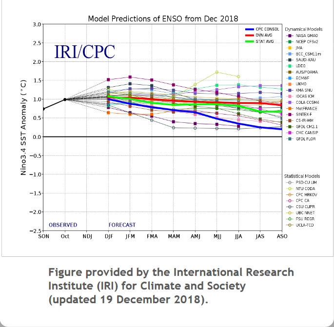
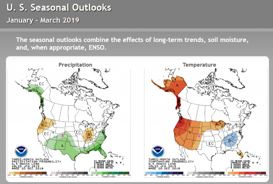
The atmosphere is in a mild El Nino/ENSO state (Figure 5) and is expected to have a good chance of remaining in that state into later this year. Historically that implies slightly above normal precipitation chances this season (January- March) for northern Colorado and even better chances for southern Colorado.  Temperatures are expected above normal for the state through the next three months as well (Figure 6).   Lets bring on that precipitation!

Figure 2: the graphical forecast for the next 10 days forecast for Longmont, CO from weatherunderground.com

Figure 3: The forecast accumulated snow map from the GFS and weather5280.com for Colorado, for the next 10 days.

Figure 4: The current drought index map for Colorado issued Jan 3, 2019 from NOAA/NWS/NCEP/CPC

Figure 5: The forecast ENSO index through ASO (August/September/October 2019) from the IRI/CPC.

Figure 6: The forecast precipitation and temperature trends from a presentation by NOAA.

Current Weather

Partly cloudy

Partly cloudy

47°F

UV Index
0 Low
Pressure
29.62 Steady
Visibility
8 miles
Dewpoint
19 °F
Humidity
33%
Wind
WSW 5.1 mph
Gust
12.1 mph
Wind Chill
45 °F

Hourly Forecast

Today
6 AM
45°F
Showers
Today
7 AM
43°F
Showers
Today
8 AM
47°F
Partly sunny w/ showers
Today
9 AM
50°F
Partly sunny
Today
10 AM
54°F
Intermittent clouds
Today
11 AM
56°F
Intermittent clouds
Today
12 PM
58°F
Mostly cloudy
Today
1 PM
59°F
Showers
Today
2 PM
61°F
Intermittent clouds
Today
3 PM
60°F
Intermittent clouds
Today
4 PM
59°F
Intermittent clouds
Today
5 PM
59°F
Intermittent clouds

7 Day Forecast

Partly sunny w/ showers

Tuesday

61 °F

Very windy; a couple of showers this morning; otherwise, times of clouds and sun


Partly cloudy

Tuesday Night

34 °F

Partly cloudy; there can be frost in the normally colder spots


Intermittent clouds

Wednesday

57 °F

Cool with times of clouds and sun


Mostly cloudy

Wednesday Night

39 °F

Increasing clouds


Partly sunny w/ showers

Thursday

56 °F

Times of clouds and sun with a couple of showers; cool


Cloudy

Thursday Night

40 °F

Cloudy


Mostly cloudy

Friday

66 °F

Mostly cloudy and warmer


Mostly clear

Friday Night

40 °F

Mainly clear


Intermittent clouds

Saturday

74 °F

Pleasant and warmer with periods of clouds and sun


Mostly clear

Saturday Night

43 °F

Mainly clear


Sunrise and Sunset

Sunrise
5:52 AM
Sunset
8:02 PM

Based on AccuWeather data