Skip to content

Next Storm/Next Snow Forecast Discussion from the Cherrywood Observatory – January 6-7, 2020

This content was originally published by the Longmont Observer and is licensed under a Creative Commons license.

In Brief:

Quiet weather Alert! We warm up to above normal through mid-week and remain dry. We have a super tiny chance of rain/snow Thursday PM and Friday AM. We cool down to below normal for the end of the week and into next week (but only by a few degrees). There are small chances of precipitation at the start of next week as well. End Quiet Weather Alert.

Forecast Discussion:

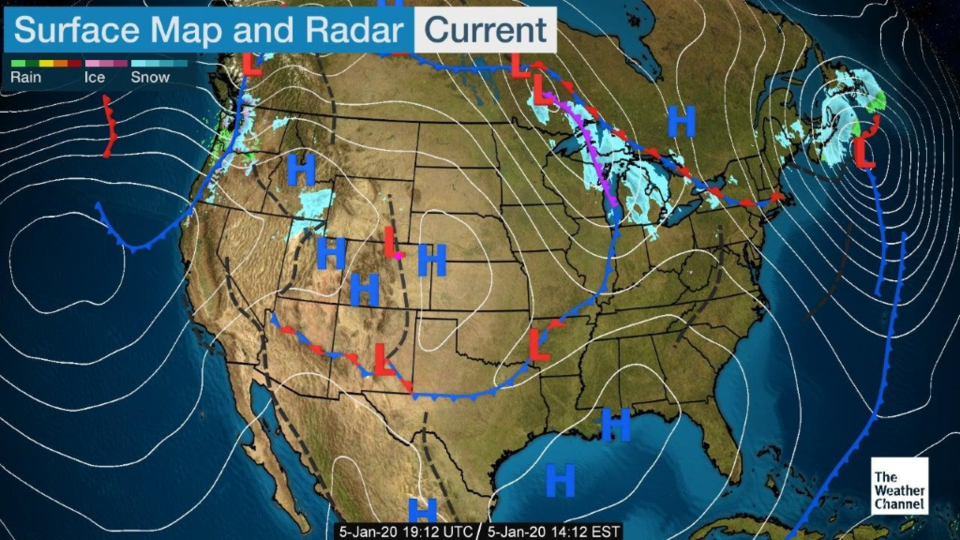
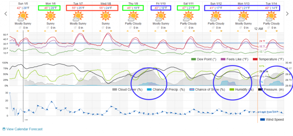
High pressure still sits anchored in place at the surface (Figure 1) and aloft. We'll see some winds Monday night with a warm front (dry) passing across the state (Figure 2) but not as strong as the down slope winds seen Saturday night (the highest wind gust in town that I can find was 48mph).

The Longer Range Forecast:

We'll see another cool front pass us Wednesday evening with a very small chance of precipitation later Thursday with the passage of some upper level support (Figure 2).
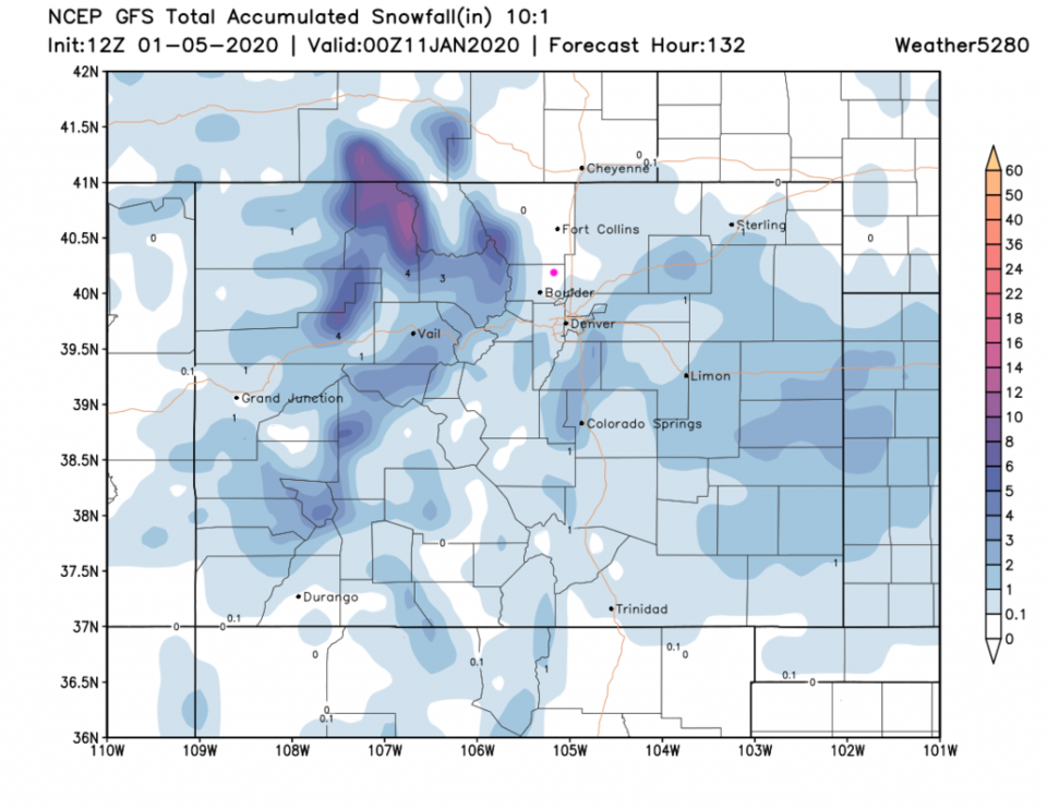
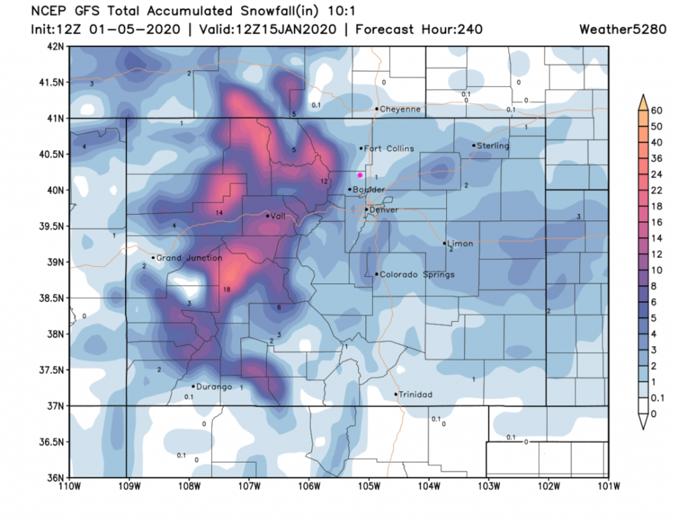
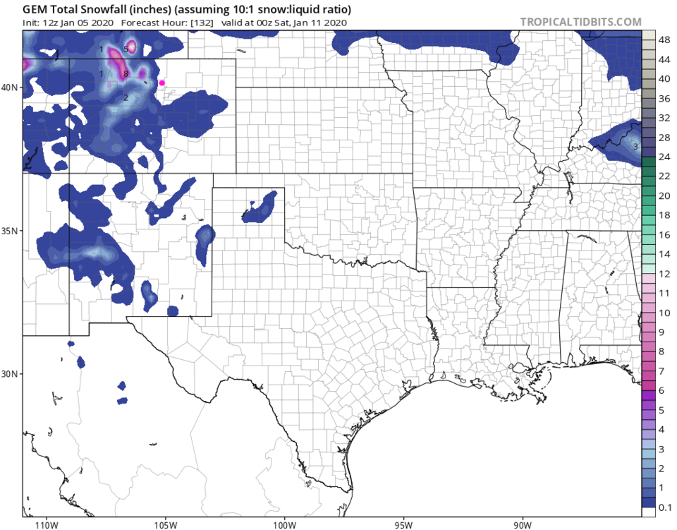
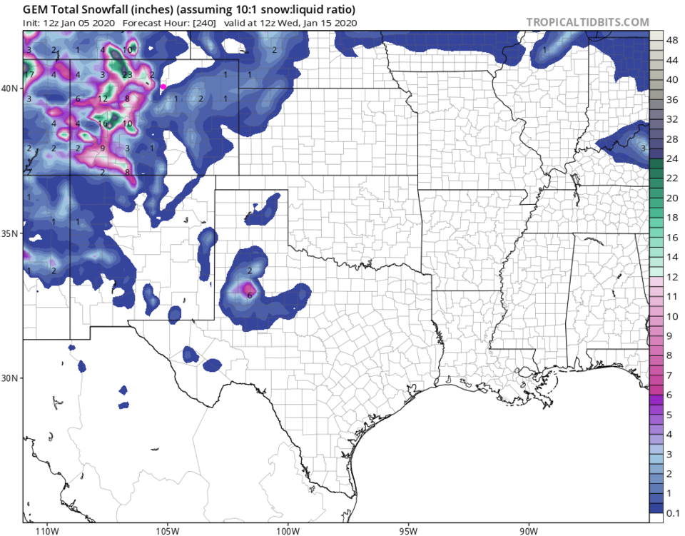
The GFS has snow in the mountains to our west and snow on the plains to the east (Figure 3). Down slope flow will probably inhibit precipitation here. The GEM (Figure 5) has the mountain snows but nothing on the Plains or in Longmont. Scooping in the next two small chances of precipitation (seen next week in Figure 2) the GFS gives us 1/2-1 inch of snow over the next 10 days (Figure 4) and the GEM keeps us dry (Figure 6) even out that far.

Another longer range forecast:

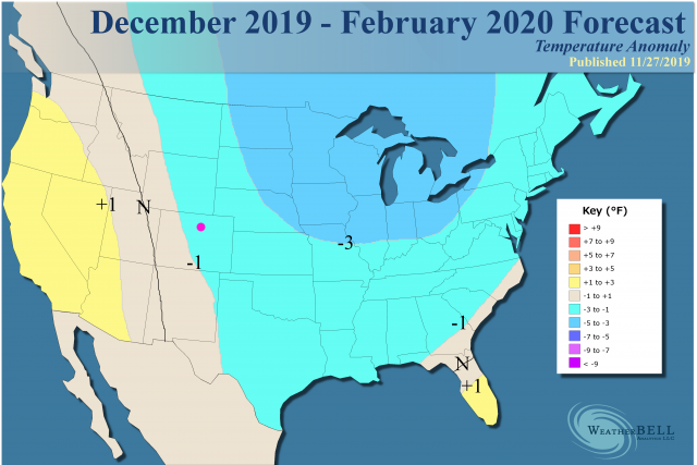
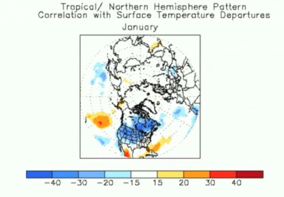
The private forecasting company WeatherBELL has a different take on the rest of the winter as compared to NOAA (covered in a prior post). With warm water off of Alaska and western Canada in the Pacific and a near-neutral ENSO index, they expect us to see a LOT of cold air flowing into the nation with Colorado on the chilly side of normal (Figure 7). More specifically, they paint the entire nation - west coast to east coast - as very much below normal for January alone (Figure 8). If that were true, the amount of cold air we'd need to come in for the last half of the month would be pretty epic. We'll see! (Note, I do have a bit more confidence in WeatherBELL - they have done better than NOAA over the last few seasons.)

Figure 1: the current surface analysis map from Sunday PM and the weatherunderground.com
Figure 2: the graphical forecast for the next 10 days for Longmont, CO from weatherunderground.com
Figure 3: 10:1 (snow to liquid) snowfall totals through Friday PM from the GFS and weather5280com for Colorado made Wednesday afternoon.
Figure 4: 10:1 (snow to liquid) snowfall totals through the next 10 days from the GFS and weather5280com for Colorado made Wednesday afternoon.
Figure 5: 10:1 (snow to liquid) snowfall totals through Friday PM from the GEM and tropicaltidbitscom for Colorado made Wednesday afternoon.
Figure 6: 10:1 (snow to liquid) snowfall totals through the next 10 days from the GEM and tropicaltidbitscom for Colorado made Wednesday afternoon.
Figure 7: The remaining winter temperature anomaly forecast from WeatherBELL.com
Figure 8: The January temperature anomaly forecast from WeatherBELL.com (public facing video).

Current Weather

Mostly cloudy

Mostly cloudy

53°F

UV Index
5 Moderate
Pressure
29.5 Steady
Visibility
8 miles
Dewpoint
22 °F
Humidity
29%
Wind
W 12.4 mph
Gust
27.4 mph
Wind Chill
53 °F

Hourly Forecast

Today
12 PM
54°F
Showers
Today
1 PM
55°F
Cloudy
Today
2 PM
56°F
Cloudy
Today
3 PM
57°F
Cloudy
Today
4 PM
57°F
Cloudy
Today
5 PM
56°F
Cloudy
Today
6 PM
55°F
Cloudy
Today
7 PM
55°F
Cloudy
Today
8 PM
53°F
Mostly cloudy
Today
9 PM
51°F
Intermittent clouds
Today
10 PM
49°F
Intermittent clouds
Today
11 PM
48°F
Partly cloudy

7 Day Forecast

Showers

Monday

57 °F

Winds gusting past 40 mph; a brief shower or two this morning; otherwise, cloudy and cooler


Intermittent clouds

Monday Night

41 °F

Partly cloudy


Partly sunny w/ showers

Tuesday

58 °F

A couple of showers in the morning; otherwise, windy and cool with times of clouds and sun


Partly cloudy

Tuesday Night

33 °F

Partly cloudy


Intermittent clouds

Wednesday

60 °F

Times of clouds and sun


Mostly cloudy

Wednesday Night

38 °F

Increasing clouds


Partly sunny w/ showers

Thursday

56 °F

Times of clouds and sun with a couple of showers; cool


Cloudy

Thursday Night

37 °F

Cloudy


Mostly cloudy

Friday

62 °F

Mostly cloudy and warmer


Mostly clear

Friday Night

36 °F

Mainly clear


Sunrise and Sunset

Sunrise
5:53 AM
Sunset
8:01 PM

Based on AccuWeather data