Skip to content

7:30am Update: Next Storm/Next Snow Forecast Discussion from the Cherrywood Observatory – July 21, 2019

This content was originally published by the Longmont Observer and is licensed under a Creative Commons license.

In Brief:

The front has arrived and anchored itself to topography of Colorado. It is serving as a trigger for thunderstorms that will ride over the cooler air and feed on easterly up slope flow. We will cool to a low high temperature of around 77F Monday then return to seasonable warm weather with afternoon storms.

7:30am Update:

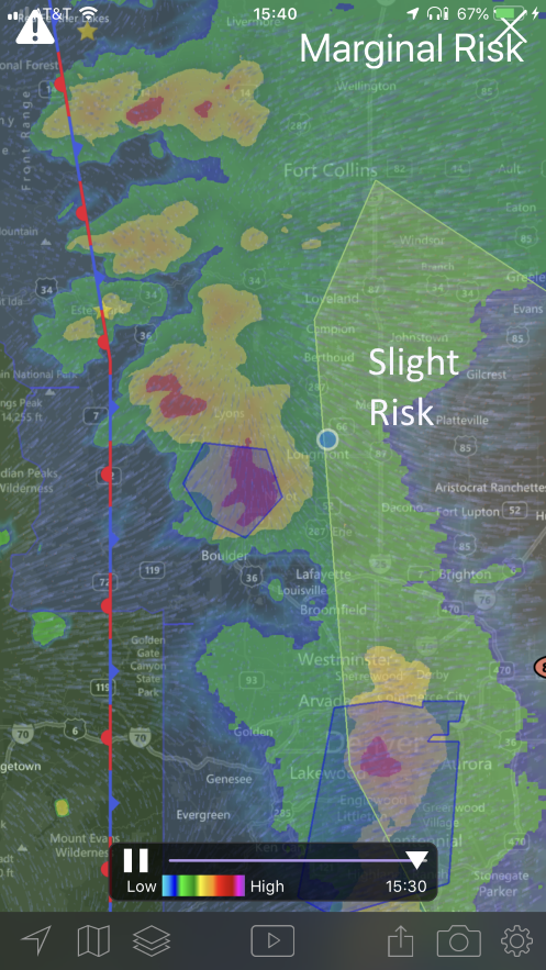
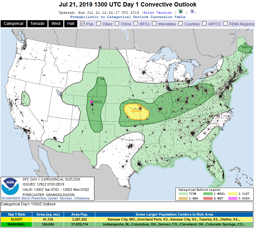
Wind shear (the change in direction and speed of winds at different heights of the atmosphere) and daytime heating (the stratus clouds are remaining further east that was expected yesterday) will be significant enough to create strong thunderstorms again today. A Marginal Risk of severe weather has been forecasted for the Front Range and much of eastern Colorado (Figure 1 update).

Hail and high winds (and a few spots of locally flooding rains) are the primary risk. We are still expecting 1/4-1/2 inch of water across the region mainly after 2pm on to late morning Monday with thunderstorms capable of dropping an inch or two in local spots.

Storms will be moving out of the northwest direction - so watch those dark skies and your weather alert apps!

Figure 1 update: The severe storm weather forecast for the U.S. from the Storm Predication Center in Norman, OK. Made Sunday for Sunday.

End 7:30am Update.

Forecast Discussion:

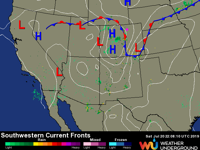
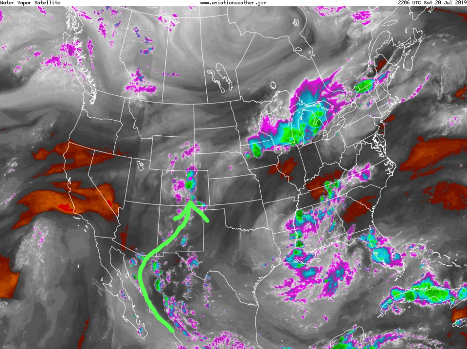
Figure 1 shows that the SPC has expanded the Slight Risk (2 on a scale of 1-5) back to Hwy 287 and the first round of storms got pretty severe around Lyons. The front is visible anchored down the mountains almost to New Mexico (Figure 2). Monsoonal moisture from the southwest and Mexico is leaking into the state from the south (Figure 3).

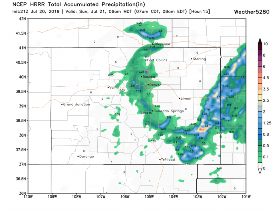
The cooler air Sunday will inhibit severe weather but rain and thunderstorms are still possible (Figure 4). By 6am the HRRR gives us a about 1/4th inch more than we received mid afternoon Saturday (Figure 5).

The Longer Range Forecast:

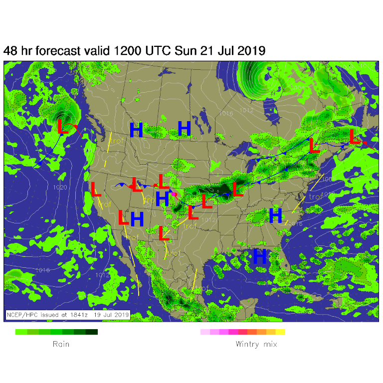
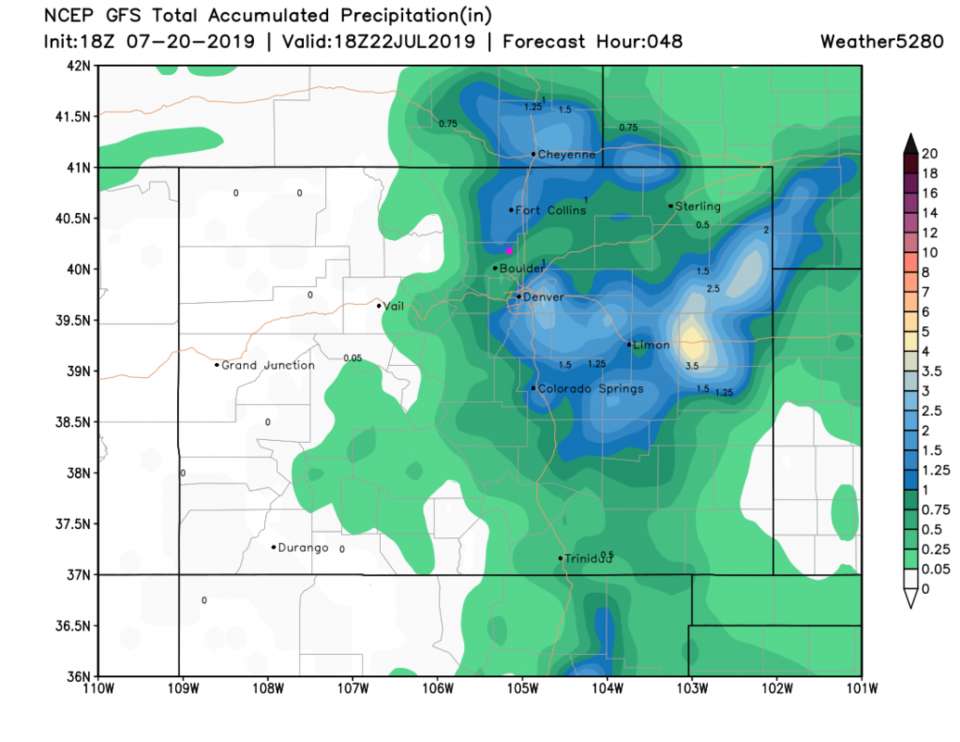
The weatherunderground.com site gives us a bit more than 1/2 inch more rain on Sunday and maybe 1/10th inch up to Monday (not shown). The GFS gives us 3/4th of an inch to 1 inch over the next 48 hours (Figure 6).

We hover just above and just below the 90F mark Tuesday through the next weekend with a return of afternoon thunderstorms.

Figure 1: The 3:40pm screen capture of the radar and SPC thunderstorm risk map from MyRadar app from iOS.
Figure 2: The current surface map analysis from weatherunderground.com
Figure 3: the water vapor satellite image (browns/reds are dry air, whites and light grey is moist air, purple/blue is ice and high cloud tops). From the the NWS.
Figure 4: The forecast surface map for Sunday AM from NCEP.
Figure 5: the forecast accumulated precipitation map from the HRRR and weather5280.com for Colorado, for the next 15 hours through 6am Sunday.
Figure 6: the forecast accumulated precipitation map from the GFS and weather5280.com for Colorado, for the next 2 days.

Current Weather

Partly sunny

Partly sunny

47°F

UV Index
2 Low
Pressure
29.89 Falling
Visibility
8 miles
Dewpoint
33 °F
Humidity
58%
Wind
NNE 2.2 mph
Gust
4.3 mph
Wind Chill
47 °F

Hourly Forecast

Today
8 AM
47°F
Partly sunny
Today
9 AM
51°F
Intermittent clouds
Today
10 AM
55°F
Intermittent clouds
Today
11 AM
59°F
Intermittent clouds
Today
12 PM
62°F
Intermittent clouds
Today
1 PM
64°F
Intermittent clouds
Today
2 PM
65°F
Intermittent clouds
Today
3 PM
64°F
Intermittent clouds
Today
4 PM
62°F
Intermittent clouds
Today
5 PM
60°F
Intermittent clouds
Today
6 PM
57°F
Mostly cloudy w/ t-storms
Today
7 PM
54°F
Intermittent clouds

7 Day Forecast

Partly sunny w/ t-storms

Wednesday

65 °F

A couple of showers this morning, becoming breezy this afternoon with a thunderstorm


Thunderstorms

Wednesday Night

38 °F

A thunderstorm this evening; otherwise, mostly cloudy


Intermittent clouds

Thursday

63 °F

A blend of sun and clouds


Mostly cloudy

Thursday Night

38 °F

Mostly cloudy


Partly sunny

Friday

64 °F

Breezy with some sun


Mostly clear

Friday Night

36 °F

Mainly clear


Partly sunny

Saturday

69 °F

Partial sunshine


Mostly clear

Saturday Night

41 °F

Clear to partly cloudy


Intermittent clouds

Sunday

78 °F

Warm with sun and areas of high clouds; breezy in the afternoon


Mostly cloudy

Sunday Night

47 °F

Rather cloudy


Sunrise and Sunset

Sunrise
5:59 AM
Sunset
7:56 PM

Based on AccuWeather data