Skip to content

7:30am Update: Next Storm/Next Snow Forecast Discussion from the Cherrywood Observatory – July 22, 2019

This content was originally published by the Longmont Observer and is licensed under a Creative Commons license.

In Brief:

Rain chances and cooler weather behind our weekend front lingers today with our lowest high temperature of the recent summer in just the upper 70's F. The front pulls away and we return to upper 80's F for highs. Monsoon-like moisture returns Wednesday giving us afternoon storm chances again.

7:30am Update:

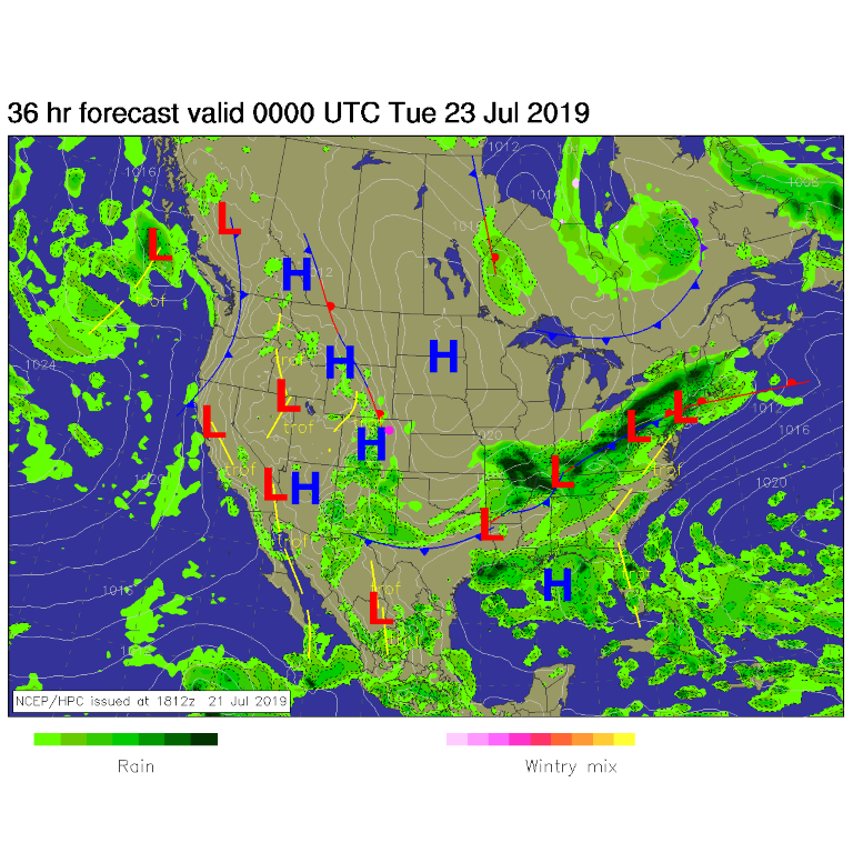
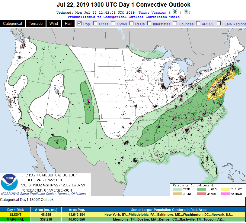
The Plains have been cooled by air flowing in from Canada, but a few storms may fire in the mountains and approach severe limits as far east as the I-25 corridor. The SPC (Figure 1 update) has painted the area as being under a Marginal Risk - for large hail and high winds. It looks like only a couple or a handful of cells will form that get that strong - most folks won't see severe conditions.

Figure 1 update: The severe storm weather forecast for the U.S. from the Storm Predication Center in Norman, OK. Made Monday for Monday.

End 7:30am Update.

Forecast Discussion:

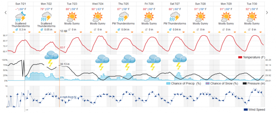
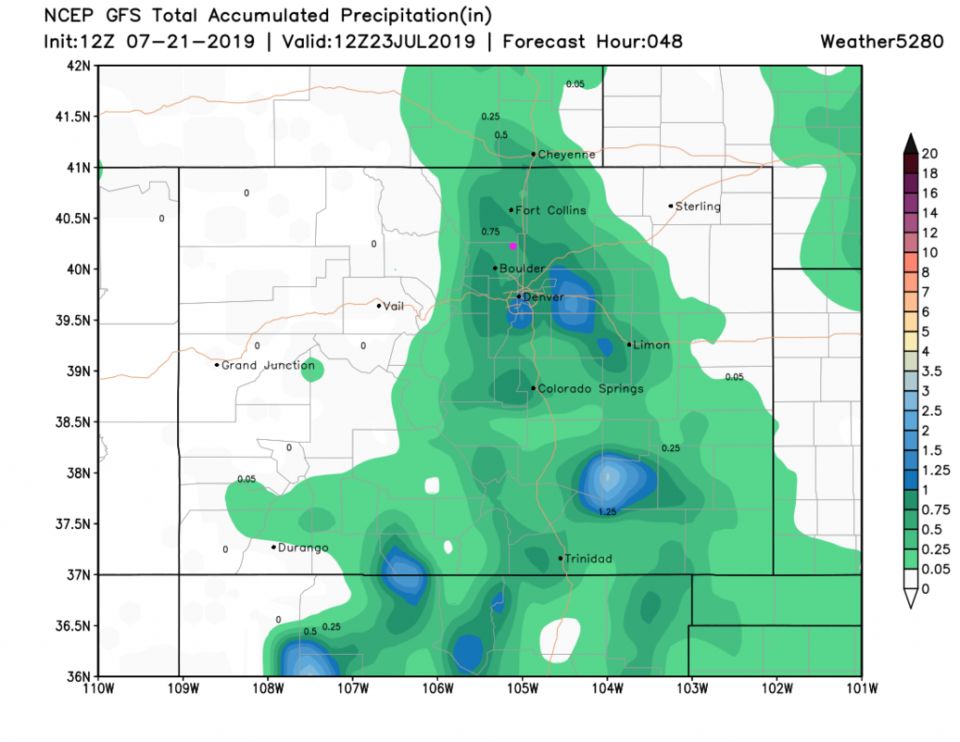
Our weekend front finally begins to head to the east Monday night (Figure 1) after we see a high today (Monday) only around 78° F (Figure 2). Marginally severe weather might return in the afternoon (but is not currently expected). I'll update here again if that changes. The GFS gives us about 1/2 inch of rain from Sunday afternoon to Monday evening (Figure 3). The wunderground model thinks we'll see only about 1/3rd inch of water.

The Longer Range Forecast:

A big upper high sets up for a while in the southwest/four corners area (Figure 4). Tropical moisture will wrap around it into Colorado suppressing the high temperatures that might have occurred. This moisture will also mean afternoon storm chances return Wednesday - but highs struggle to break 90° F this week.

Figure 1: The forecast surface map for Monday night from NCEP.
Figure 2: the graphical forecast for the next 10 days for Longmont, CO from weatherunderground.com
Figure 3: the forecast accumulated precipitation map from the GFS and weather5280.com for Colorado, for the next 2 days.
Figure 4: The 500mb forecast upper air analysis for Tuesday AM. Pink dot is Longmont. Red lines are troughs, blue lines are ridges.

Current Weather

Cloudy

Cloudy

40°F

UV Index
1 Low
Pressure
29.96 Rising
Visibility
8 miles
Dewpoint
38 °F
Humidity
94%
Wind
W 1.2 mph
Gust
2.4 mph
Wind Chill
40 °F

Hourly Forecast

Today
9 AM
43°F
Cloudy
Today
10 AM
47°F
Mostly cloudy
Today
11 AM
51°F
Mostly cloudy
Today
12 PM
53°F
Cloudy
Today
1 PM
56°F
Cloudy
Today
2 PM
58°F
Cloudy
Today
3 PM
59°F
Thunderstorms
Today
4 PM
60°F
Mostly cloudy
Today
5 PM
62°F
Mostly cloudy
Today
6 PM
60°F
Mostly cloudy
Today
7 PM
58°F
Intermittent clouds
Today
8 PM
55°F
Intermittent clouds

7 Day Forecast

Thunderstorms

Sunday

62 °F

Mostly cloudy and warmer with a thundershower in spots


Intermittent clouds

Sunday Night

38 °F

Partly cloudy


Partly sunny

Monday

70 °F

Partly sunny, pleasant and warmer


Intermittent clouds

Monday Night

44 °F

Partly cloudy


Mostly sunny

Tuesday

73 °F

Mostly sunny and pleasant


Intermittent clouds

Tuesday Night

41 °F

Clearing


Intermittent clouds

Wednesday

65 °F

Times of sun and clouds


Intermittent clouds

Wednesday Night

39 °F

A thundershower in spots in the evening; otherwise, partly cloudy


Rain

Thursday

56 °F

Cooler with occasional rain and drizzle; breezy in the morning


Partly cloudy

Thursday Night

32 °F

Partly cloudy


Sunrise and Sunset

Sunrise
6:03 AM
Sunset
7:53 PM

Based on AccuWeather data