Skip to content

Next Storm/Next Snow Forecast Discussion from the Cherrywood Observatory – June 13, 2019

This content was originally published by the Longmont Observer and is licensed under a Creative Commons license.

In Brief:

With a ridge overhead, we soar to the 80's F for a couple of days. Moisture returns with the heat - so afternoon thunderstorms (we'll have to watch the severe chances) return today (Thursday) as well. A cool front comes in for the the weekend. We cool to the 70's F and have pretty good daily chances of rain and thundershowers.

Forecast Discussion:

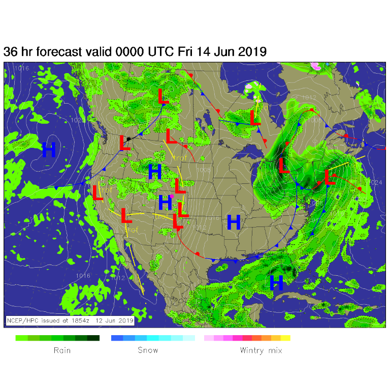
Widely scattered storms will form in the mountains and move eastward this afternoon (Thursday- Figure 1). High pressure at the surface and aloft mean heat - temperatures in the mid to upper 80's F.

Meteorologist Matt Makins (via Twitter @MattMakens) posted some interesting statistics. "Interesting Denver weather tidbits: In 2018 through June 10th, we had 12 days in the 90s. Yet in 2019 through June 10th, we have yet to hit the 90s and have only been 80°+ 8 times."

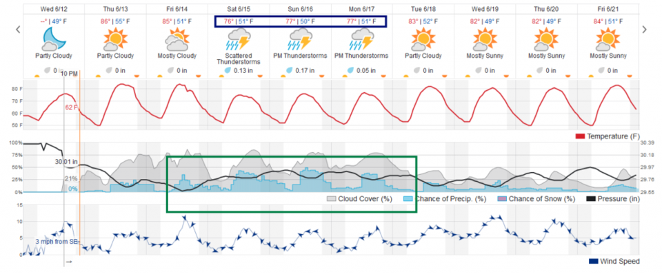
There are no 90's+ F in the forecast and longer range models show the cool (and moist) conditions will continue for a number of weeks to come, overall (Figure 2).

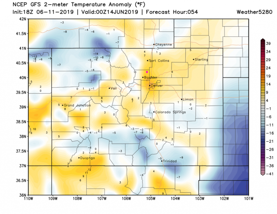
The heat Thursday will be about 7 to 9 degrees F above normal (Figure 3). Thursday and Friday are the warmest days.

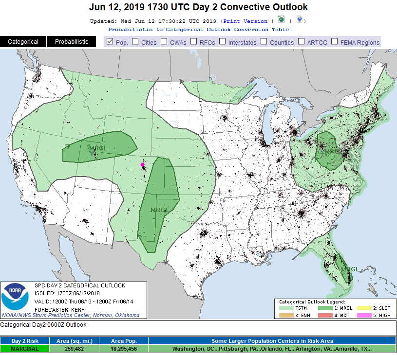
With heat and moisture - will we see severe weather return? Figure 5 shows a Marginal Risk (1 on a scale of 1-5) out on the Eastern Plains. We HAVE seen this get expanded westward on the day of the event a number of times. I'll update this post if the SPC changes the western boundary.

The Longer Range Forecast:

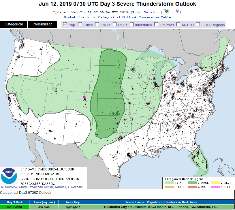
Similar to Thursday, there is a chance of severe weather out on the Plains on Friday as well (Figure 6). It doesn't extend back to the I-25 folks, but that might change.

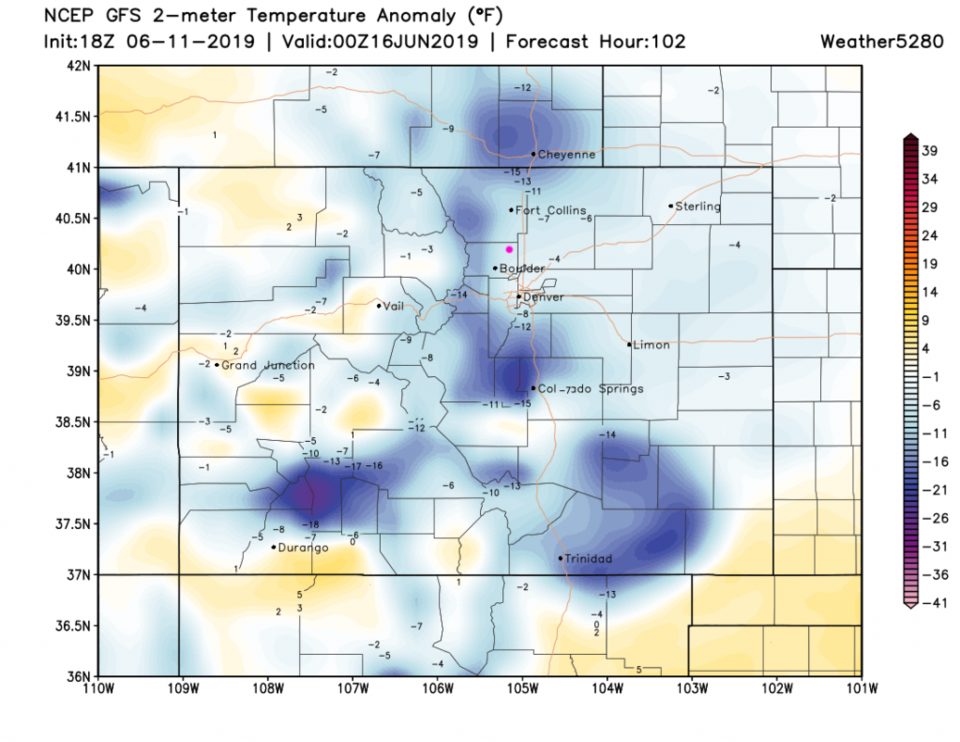
The cool down on Saturday (Figure 4) knocks the temperatures to some 6-8 degrees F below average.

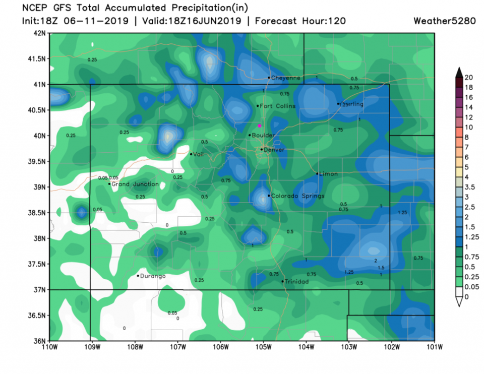
Figure 2 shows that there are elevated chances of rain beginning Friday and continuing to Monday (green box). The coolest period spans Saturday to Monday (black box). Over the next 5 days, the GFS gives about a quarter of the state up to 1 inch or more of rain and a lot of folks 1/2 inch or more rainfall. Don't trust any one spot (like the pink dot for Longmont where there is exactly 1/2 inch of water) but this pattern and overall rainfall highlights are probably reliable.

Figure 1: The forecast surface map for Thursday night from NCEP.
Figure 2: the graphical forecast for the next 10 days for Longmont, CO from weatherunderground.com
Figure 3: The forecast temperature departure from normal map from the GFS and weather5280.com for Colorado, Thursday PM.
Figure 4: The forecast temperature departure from normal map from the GFS and weather5280.com for Colorado, Saturday PM.
Figure 5: The severe storm weather forecast for the U.S. from the Storm Predication Center in Norman, OK. Made Wednesday for Thursday.
Figure 6: The severe storm weather forecast for the U.S. from the Storm Predication Center in Norman, OK. Made Wednesday for Friday.
Figure 7: the forecast accumulated precipitation map from the GFS and weather5280.com for Colorado,over the next 5 days.

Current Weather

Rain

Rain

49°F

UV Index
0 Low
Pressure
29.72 Rising
Visibility
7 miles
Dewpoint
44 °F
Humidity
83%
Wind
NE 4.6 mph
Gust
8.2 mph
Wind Chill
47 °F

Hourly Forecast

Today
8 PM
56°F
Thunderstorms
Today
9 PM
53°F
Thunderstorms
Today
10 PM
50°F
Thunderstorms
Today
11 PM
48°F
Thunderstorms
Tomorrow
12 AM
46°F
Cloudy
Tomorrow
1 AM
46°F
Cloudy
Tomorrow
2 AM
45°F
Cloudy
Tomorrow
3 AM
44°F
Rain
Tomorrow
4 AM
44°F
Cloudy
Tomorrow
5 AM
44°F
Rain
Tomorrow
6 AM
44°F
Rain
Tomorrow
7 AM
44°F
Rain

7 Day Forecast

Mostly cloudy w/ t-storms

Friday

69 °F

Variable cloudiness with a couple of thundershowers this afternoon; gusty winds and small hail can accompany any downpour


Thunderstorms

Friday Night

41 °F

Cloudy; a couple of showers and a thunderstorm this evening followed by periods of rain late; gusty winds and small hail can accompany any downpour


Rain

Saturday

44 °F

Chilly with periods of rain and a thunderstorm; travel in the foothills and mountains will be slippery due to snow


Rain and snow

Saturday Night

36 °F

Cloudy with rain, mixed with a little snow late; travel in the foothills and mountains will be slippery due to snow


Mostly cloudy

Sunday

61 °F

Mostly cloudy and warmer


Intermittent clouds

Sunday Night

36 °F

A thunderstorm in spots in the evening; otherwise, partly cloudy


Partly sunny

Monday

71 °F

Partly sunny, pleasant and warmer


Partly cloudy

Monday Night

45 °F

Partly cloudy


Mostly sunny

Tuesday

73 °F

Pleasant with sunshine and patchy clouds


Partly cloudy

Tuesday Night

40 °F

Partly cloudy


Sunrise and Sunset

Sunrise
6:06 AM
Sunset
7:51 PM

Based on AccuWeather data