Skip to content

Next Storm/Next Snow Forecast Discussion from the Cherrywood Observatory – June 16, 2019

This content was originally published by the Longmont Observer and is licensed under a Creative Commons license.

In Brief:

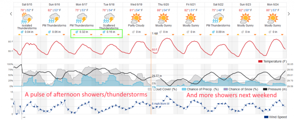
We have daily afternoon chances of rain and thunderstorms Saturday through Wednesday with below normal temperatures. Heaver rain amounts are expected Monday and Tuesday. Some severe weather (hail and high winds are the primary risk) is possible Sunday afternoon.

Forecast Discussion:

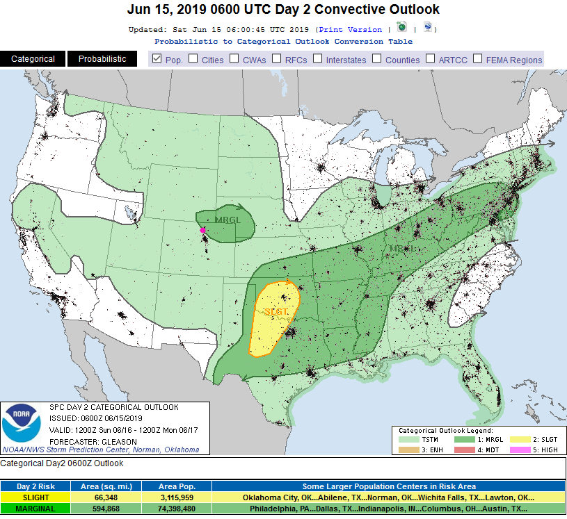
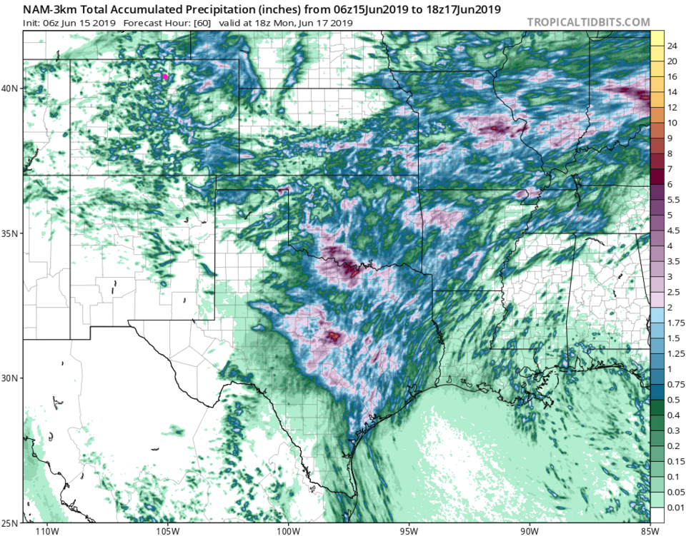
The front is in place down the Plains and up into the Foothills (Figure 1). This has stabilized the atmosphere significantly (Saturday afternoon). Moisture is more limited (especially north of I70) with precipitable amounts only around 0.63 inches this morning at DIA. Except where the lucky thundershower travels, most locations will see less than a 1/10th of an inch of water today (Saturday afternoon) and severe weather is not expected (Figure 3).

The Longer Range Forecast:

Tomorrow (Sunday) we have a couple of periods of rainfall - around noon and around sunset - possible (Figure 2). There is a Marginal Risk (1 on a scale of 1-5) for thunderstorms to create damaging hail and high winds over NE Colorado.

The GFS gives most locations under 1/2 inch of water over the next 5 days with lucky locations getting 1-2 inches (Figure 5). The NAM, over the next 2.5 days, shows how very spotty this convective precipitation will be (Figure 6).

Figure 1: The forecast surface map for Sunday AM from NCEP.
Figure 2: the graphical forecast for the next 10 days for Longmont, CO from weatherunderground.com
Figure 3: The severe storm weather forecast for the U.S. from the Storm Predication Center in Norman, OK. Made Saturday for Saturday.
Figure 4: The severe storm weather forecast for the U.S. from the Storm Predication Center in Norman, OK. Made Saturday for Sunday.
Figure 5: the forecast accumulated precipitation map from the GFS and weather5280.com for Colorado,over the next 5 days.
Figure 6: the forecast accumulated precipitation map from the NAM and tropicaltidbits.com for Colorado,over the next 2.5 days.

Current Weather

Mostly sunny

Mostly sunny

53°F

UV Index
4 Moderate
Pressure
29.98 Falling
Visibility
8 miles
Dewpoint
37 °F
Humidity
54%
Wind
W 1.6 mph
Gust
4.6 mph
Wind Chill
53 °F

Hourly Forecast

Today
10 AM
58°F
Partly sunny
Today
11 AM
62°F
Partly sunny
Today
12 PM
64°F
Partly sunny
Today
1 PM
67°F
Partly sunny
Today
2 PM
68°F
Partly sunny
Today
3 PM
69°F
Partly sunny
Today
4 PM
70°F
Partly sunny
Today
5 PM
68°F
Partly sunny
Today
6 PM
67°F
Partly sunny
Today
7 PM
65°F
Partly sunny
Today
8 PM
61°F
Intermittent clouds
Today
9 PM
58°F
Intermittent clouds

7 Day Forecast

Partly sunny

Monday

70 °F

Partly sunny and pleasant


Intermittent clouds

Monday Night

44 °F

Partly cloudy


Mostly sunny

Tuesday

74 °F

Mostly sunny; windy in the morning, then pleasant in the afternoon


Intermittent clouds

Tuesday Night

44 °F

Clearing


Partly sunny w/ showers

Wednesday

65 °F

Periods of clouds and sun, becoming breezy with a passing shower in the afternoon


Mostly cloudy

Wednesday Night

39 °F

A thundershower in parts of the area in the evening; otherwise, mostly cloudy


Intermittent clouds

Thursday

57 °F

Windy in the morning; cooler with intervals of clouds and sun


Mostly clear

Thursday Night

32 °F

Mainly clear


Partly sunny

Friday

68 °F

Warmer with some sun


Partly cloudy

Friday Night

33 °F

Partly cloudy


Sunrise and Sunset

Sunrise
6:02 AM
Sunset
7:54 PM

Based on AccuWeather data