Skip to content

Next Storm/Next Snow Forecast Discussion from the Cherrywood Observatory – June 23, 2019

This content was originally published by the Longmont Observer and is licensed under a Creative Commons license.

In Brief:

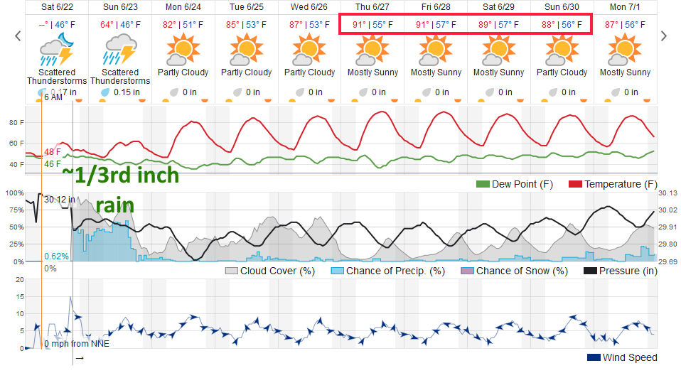
Rain will continue through Sunday afternoon (maybe finally tapering off around 1-3pm). We quickly dry out and rise back to the 80's F. That begins our warm-up to real heat in the lower 90's F (our first 90°+ F day) Thursday. There is a hint of things cooling a bit at the end of next weekend into next week with increasing afternoon thundershowers.

Forecast Discussions:

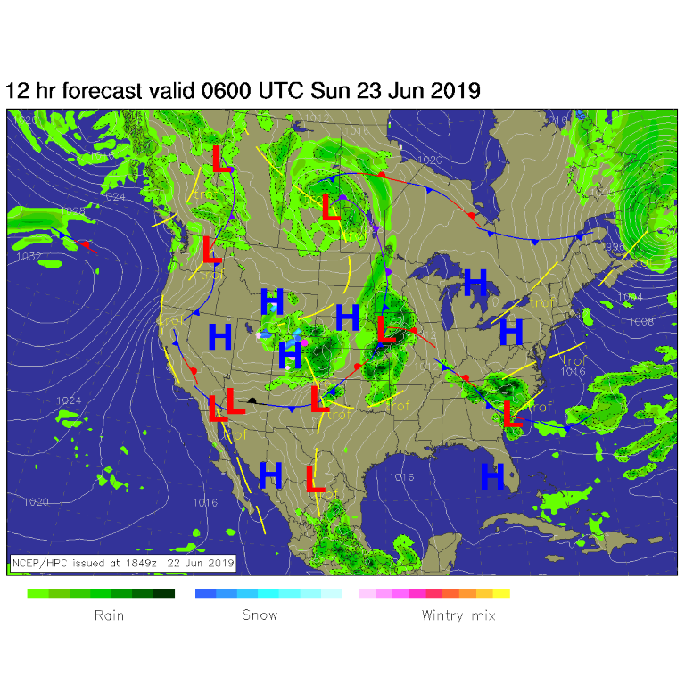
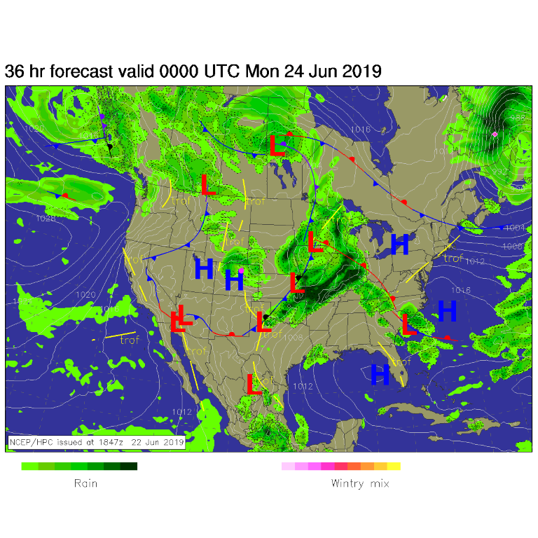
Rain, heavy at times, continue off and on overnight Saturday into Sunday tapering off in the afternoon. Figure 1 is the rain coverage around midnight Saturday/Sunday. Figure 2 is Sunday later afternoon. Some showers will be possible in places.

Weatherunderground.com gives us about 1/3rd inch more rainfall after 6pm Saturday - but a thundershower will quickly dump more than that (Figure 2).

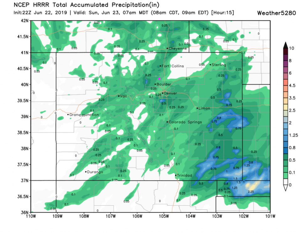
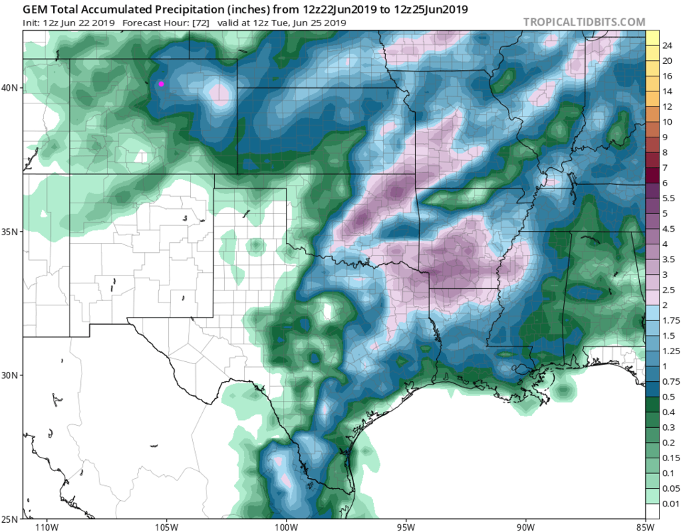
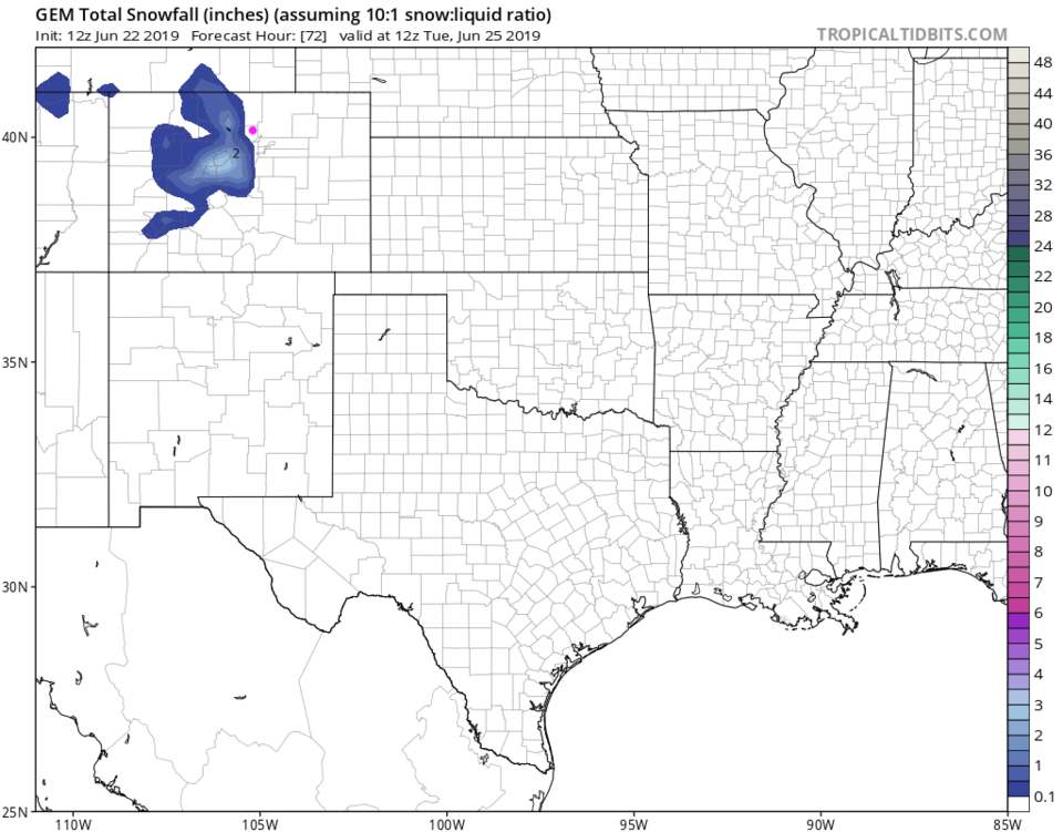
The HRRR gives us 0.1 to 0.25 inch of rain by 7 a.m, Sunday. The GEM model gives us 0.75 to 1 inch more for the remaining storm through Sunday evening (Figure 5). The higher elevations still pick up 1-2 inches above around 9500 feet and up to 3 inches at the highest elevations (Figure 6).

The Longer Range Forecast:

The long range is quite boring now - with 80's F returning Monday with our first 90°+ F day most likely being Thursday. That heat wave should begin to wane at the start of next-next week (Figure 3).

Figure 1: The forecast surface map for late Saturday night midnight from NCEP.
Figure 2: The forecast surface map for late Sunday night midnight from NCEP.
Figure 3: the graphical forecast for the next 10 days for Longmont, CO from weatherunderground.com
Figure 4: the forecast accumulated precipitation map from the HRRR and weather5280.com for Colorado,over the next 15 hours through 7am Sunday.
Figure 5: the forecast accumulated precipitation map from the GEM and tropicaltidbits.com for Colorado,through Tuesday AM.
Figure 6: the forecast accumulated snowfall map from the GEM and tropicaltidbits.com for Colorado,through Tuesday AM.

Current Weather

Mostly sunny

Mostly sunny

54°F

UV Index
3 Moderate
Pressure
29.63 Falling
Visibility
8 miles
Dewpoint
22 °F
Humidity
29%
Wind
WSW 7.5 mph
Gust
17.8 mph
Wind Chill
54 °F

Hourly Forecast

Today
10 AM
55°F
Showers
Today
11 AM
57°F
Intermittent clouds
Today
12 PM
58°F
Mostly cloudy
Today
1 PM
59°F
Mostly cloudy
Today
2 PM
60°F
Intermittent clouds
Today
3 PM
62°F
Intermittent clouds
Today
4 PM
60°F
Intermittent clouds
Today
5 PM
58°F
Intermittent clouds
Today
6 PM
56°F
Intermittent clouds
Today
7 PM
54°F
Intermittent clouds
Today
8 PM
51°F
Intermittent clouds
Today
9 PM
48°F
Partly cloudy

7 Day Forecast

Partly sunny w/ showers

Tuesday

62 °F

A brief morning shower or two; otherwise, windy with times of clouds and sun


Partly cloudy

Tuesday Night

34 °F

Partly cloudy and colder; there can be frost in the normally colder spots


Intermittent clouds

Wednesday

59 °F

Cool with times of clouds and sun


Mostly cloudy w/ showers

Wednesday Night

37 °F

Increasing clouds with a shower in spots late


Partly sunny w/ showers

Thursday

56 °F

Times of clouds and sun with a couple of showers; cool


Cloudy

Thursday Night

40 °F

Cloudy


Mostly cloudy

Friday

66 °F

Mostly cloudy and warmer


Mostly clear

Friday Night

40 °F

Mainly clear


Mostly sunny

Saturday

74 °F

Mostly sunny, pleasant and warmer


Mostly clear

Saturday Night

43 °F

Mainly clear


Sunrise and Sunset

Sunrise
5:52 AM
Sunset
8:02 PM

Based on AccuWeather data