Skip to content

Next Storm/Next Snow Forecast Discussion from the Cherrywood Observatory – June 6, 2019

This content was originally published by the Longmont Observer and is licensed under a Creative Commons license.

In Brief:

If it wasn't for the cold fronts coming this weekend, this would be a very boring discussion. In advance of that, we'll see above average temperatures and a small chance of an afternoon thunderstorm. The main front arrives mid-afternoon Saturday with a better chance of showers/thunderstorms.

Sunday is cool with slowly clearing clouds. We remain just below 80F for much of next week with some afternoon rain chances.

Forecast Discussion:

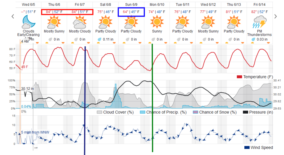
Today (Thursday) will see very low chances of afternoon storms (more in the southern mountains again - Figure 1). We end the week with above average high temperatures (mid 80'sF). The first surge of cool air comes in Friday afternoon (blue line - Figure 2) with a slightly better chance of showers. We are cooled 10F on Saturday.

The Longer Range Forecast:

The next front comes in Saturday afternoon (with the big peak in rain chances - not marked by an added graphic- Figure 2) and we cool another 10F going into Sunday.

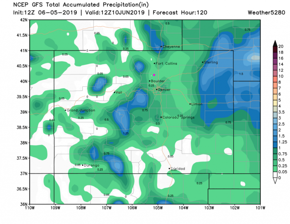
This double shot of cool air is coming in thanks to a big trough north of the state (Figure 3). Rain amounts over the next 5 days (the green line in Figure 2 - and painted out in Figure 4) show Longmont getting minimal rain totals, but lucky folks in the mountains and out on the eastern plains will break 1 inch of water.

There isn't any severe weather on the near horizon either. Any storm can be dangerous with local flooding, lightning, and a blast of strong winds. Respect the storms, especially if you are up in the mountains!

Figure 1: The forecast surface map for Thursday night from NCEP.
Figure 2: the graphical forecast for the next 10 days for Longmont, CO from weatherunderground.com
Figure 3: The 500mb forecast upper air analysis for Sunday AM. Pink dot is Longmont. Red lines are troughs, blue lines are ridges.
Figure 4: the forecast accumulated precipitation map from the GFS and weather5280.com for Colorado,over the next 5 days.

Current Weather

Partly sunny

Partly sunny

58°F

UV Index
8 Very High
Pressure
29.89 Falling
Visibility
8 miles
Dewpoint
42 °F
Humidity
55%
Wind
SSE 2.7 mph
Gust
7.2 mph
Wind Chill
58 °F

Hourly Forecast

Today
2 PM
57°F
Thunderstorms
Today
3 PM
58°F
Thunderstorms
Today
4 PM
60°F
Mostly cloudy
Today
5 PM
62°F
Mostly cloudy
Today
6 PM
60°F
Mostly cloudy
Today
7 PM
58°F
Intermittent clouds
Today
8 PM
55°F
Intermittent clouds
Today
9 PM
52°F
Intermittent clouds
Today
10 PM
49°F
Intermittent clouds
Today
11 PM
46°F
Intermittent clouds
Tomorrow
12 AM
45°F
Partly cloudy
Tomorrow
1 AM
43°F
Partly cloudy

7 Day Forecast

Thunderstorms

Sunday

62 °F

Mostly cloudy and warmer with a thundershower in spots


Intermittent clouds

Sunday Night

38 °F

Partly cloudy


Partly sunny

Monday

70 °F

Partly sunny, pleasant and warmer


Intermittent clouds

Monday Night

44 °F

Partly cloudy


Mostly sunny

Tuesday

73 °F

Mostly sunny and pleasant


Intermittent clouds

Tuesday Night

41 °F

Clearing


Intermittent clouds

Wednesday

65 °F

Times of sun and clouds


Intermittent clouds

Wednesday Night

39 °F

A thundershower in spots in the evening; otherwise, partly cloudy


Rain

Thursday

56 °F

Cooler with occasional rain and drizzle; breezy in the morning


Partly cloudy

Thursday Night

32 °F

Partly cloudy


Sunrise and Sunset

Sunrise
6:03 AM
Sunset
7:53 PM

Based on AccuWeather data