Skip to content

8:30pm Update: Next Storm/Next Snow Forecast Discussion from the Cherrywood Observatory – June 9-10, 2019

This content was originally published by the Longmont Observer and is licensed under a Creative Commons license.

In Brief:

Today, will be chilly with a high in the lower 60'sF. This front pulls away overnight and we warm to nearly 80F Monday. A cool/wind shift comes through in the evenings Monday and Tuesday keeping the warmth a bit tempered. We return to highs near 80F for the rest of the week and afternoon thundershowers coming off the mountains each day.

8:30pm Update:

Everything is on track after a chilly Sunday. We will rise to upper 70'sF for a high on Monday with dry conditions. I'm going to go play board games with the family instead of load a bunch of graphics about nice weather here tonight. Have a nice week everyone.

End 8:30pm Update.

Forecast Discussion:

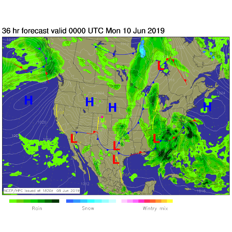
We have a little chance of a shower now and then in the cool air today (Figure 1) but the front is far to our south and east. The stratus clouds of the morning will give way to partly cloudy skies later today.

The Longer Range Forecast:

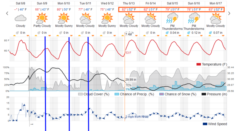
There isn't much to cover at this point - a couple of wind shift lines (weak fronts) will come through Sunday PM (and bring warmer air back) and Monday and Tuesday PM. We will approach 80F Monday right after our chilly Sunday (Figure 2). We will see things cool slightly to the mid 70'sF by Wednesday - then stabilize around 80F with a return of wandering afternoon thunderstorms. Enjoy your weekend! (Sorry this went up later than normal on Sunday - I couldn't reach the editor tool for some reason last night. )

Figure 1: The forecast surface map for Sunday evening from NCEP.
Figure 2: the graphical forecast for the next 10 days for Longmont, CO from weatherunderground.com

Current Weather

Partly sunny

Partly sunny

54°F

UV Index
6 High
Pressure
29.5 Falling
Visibility
8 miles
Dewpoint
22 °F
Humidity
28%
Wind
W 12.4 mph
Gust
29.5 mph
Wind Chill
55 °F

Hourly Forecast

Today
2 PM
57°F
Showers
Today
3 PM
57°F
Cloudy
Today
4 PM
57°F
Cloudy
Today
5 PM
56°F
Cloudy
Today
6 PM
55°F
Cloudy
Today
7 PM
55°F
Cloudy
Today
8 PM
53°F
Mostly cloudy
Today
9 PM
51°F
Intermittent clouds
Today
10 PM
49°F
Intermittent clouds
Today
11 PM
48°F
Partly cloudy
Tomorrow
12 AM
47°F
Mostly clear
Tomorrow
1 AM
47°F
Mostly clear

7 Day Forecast

Showers

Monday

57 °F

Winds becoming strong; mostly cloudy and cooler with brief showers this morning followed by a shower in spots this afternoon


Intermittent clouds

Monday Night

41 °F

Partly cloudy


Partly sunny w/ showers

Tuesday

58 °F

A couple of showers in the morning; otherwise, windy and cool with times of clouds and sun


Partly cloudy

Tuesday Night

33 °F

Partly cloudy


Intermittent clouds

Wednesday

60 °F

Times of clouds and sun


Mostly cloudy

Wednesday Night

38 °F

Increasing clouds


Partly sunny w/ showers

Thursday

56 °F

Times of clouds and sun with a couple of showers; cool


Cloudy

Thursday Night

37 °F

Cloudy


Mostly cloudy

Friday

62 °F

Mostly cloudy and warmer


Mostly clear

Friday Night

36 °F

Mainly clear


Sunrise and Sunset

Sunrise
5:53 AM
Sunset
8:01 PM

Based on AccuWeather data