This content was originally published by the Longmont Observer and is licensed under a Creative Commons license.
In Brief:
Our weather is about to be dictated by a persistent semi-cutoff low that will wobble around the southwestern U.S. for the foreseeable future. The first piece of the low to eject will roll over Colorado Friday with a blob of moisture but not much cold air. We might see early morning snow at the start of the precipitation and some snow at the end. Temperatures are pretty mild for snow. The previous forecast had very cold and snowy conditions beginning Tuesday next week. It now looks like it will still be very moist but much warmer. More on that later!
Update 3/13 9:30am:
The moisture has been VERY slow to arrive in northern Colorado. The first wave of snow is passing Boulder at this time. Early precipitation may evaporate before much of it reaches the ground. The HRRR (Figure 1 update) shows that big down-stream down slope created hole in the snow including Longmont. The HRRR also has no significant rainfall arrive here either (not shown). The NWS is still calling for some precipitation falling mainly as snow and the GFS gives us a small amount of rain, but I'm not excited that much will fall from the sky in Longmont. P.S. the NAM is quite an outlier and gives us 1-2 inches of snow today. Hmmm. (Minor update, as of 10:30a snow is reaching the ground and wetting the pavement.)

End 3/13 9:30am update.
Update 3/12 9:30am :
The upper level low to our southwest is dipping a bit further south than expected and a bit more cold air is expected to come in behind a cold front entering the state later today. The NWS is calling for some light freezing drizzle overnight followed by enough snow that you'll have to clean your windshield off in the AM. They are calling for mainly light snow showers in the day Friday (instead of rain as I was forecasting) but with warm temperatures, the ground should remain wet. Showers will depart the state Friday evening. It looks like we'll receive 0.10 to 0.25 inch of water in the end.
End 3/12 9:30am update.
Forecast Discussion:
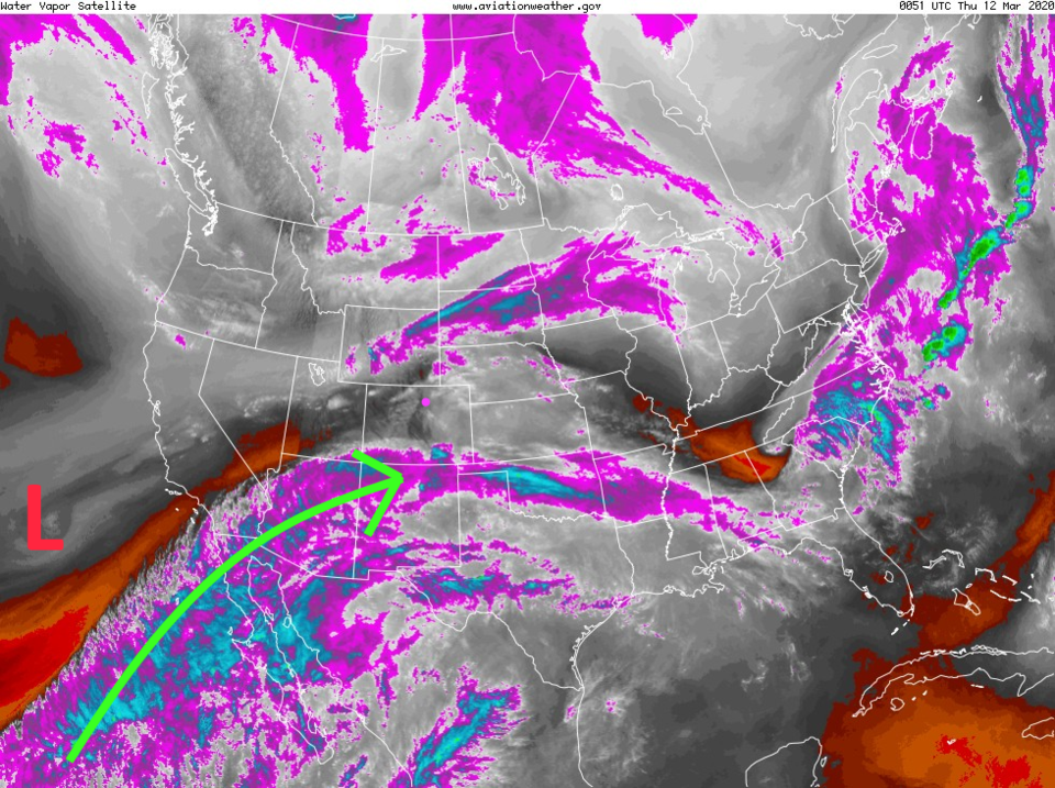
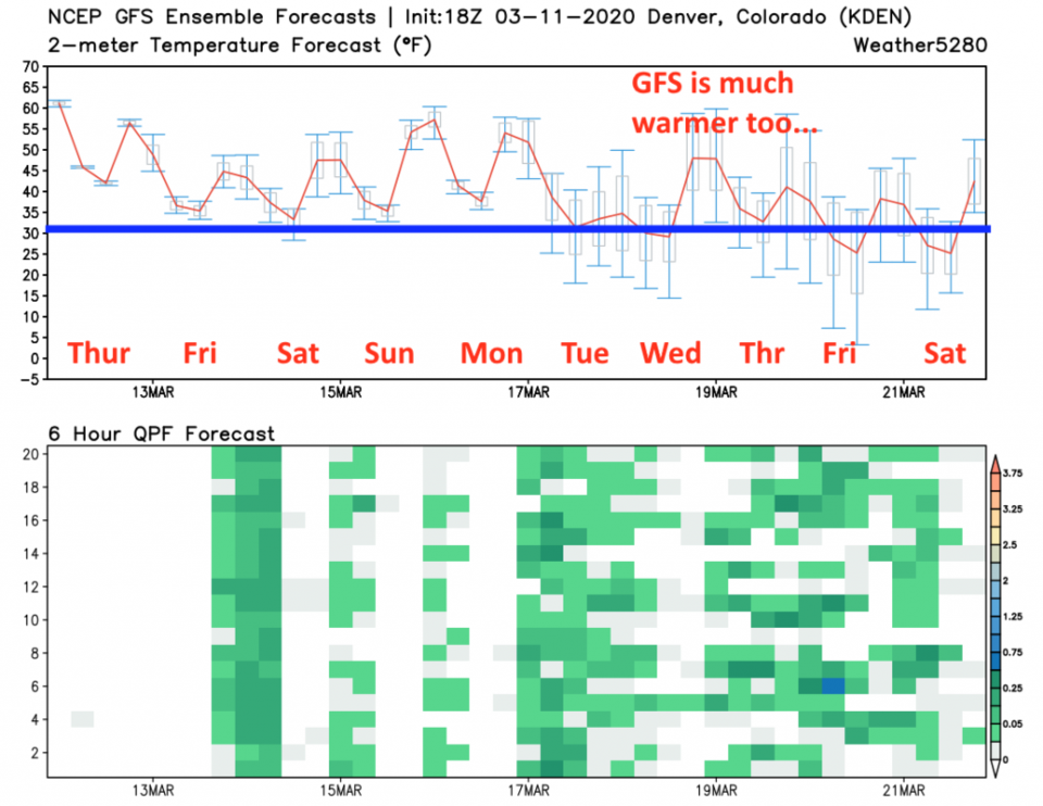
Oh how strange and independent a cutoff low can be. If you watch the video forecast (bottom of page, Figure 11) made Tuesday PM for Thursday - Saturday, the cutoff low was going to dig fairly deep to the south and eject pieces of energy to the northeast over Colorado bringing in really cold air and giving us snow for a long time. That Low is still wandering in (detached from the main jet stream flow - Figure 1) and moisture is still streaming up ahead of it. But it now looks like it won't go as far south. This will still mean rain/snow, but temperatures will be much more marginal - very close to freezing (Figure 2 and Figure 3).
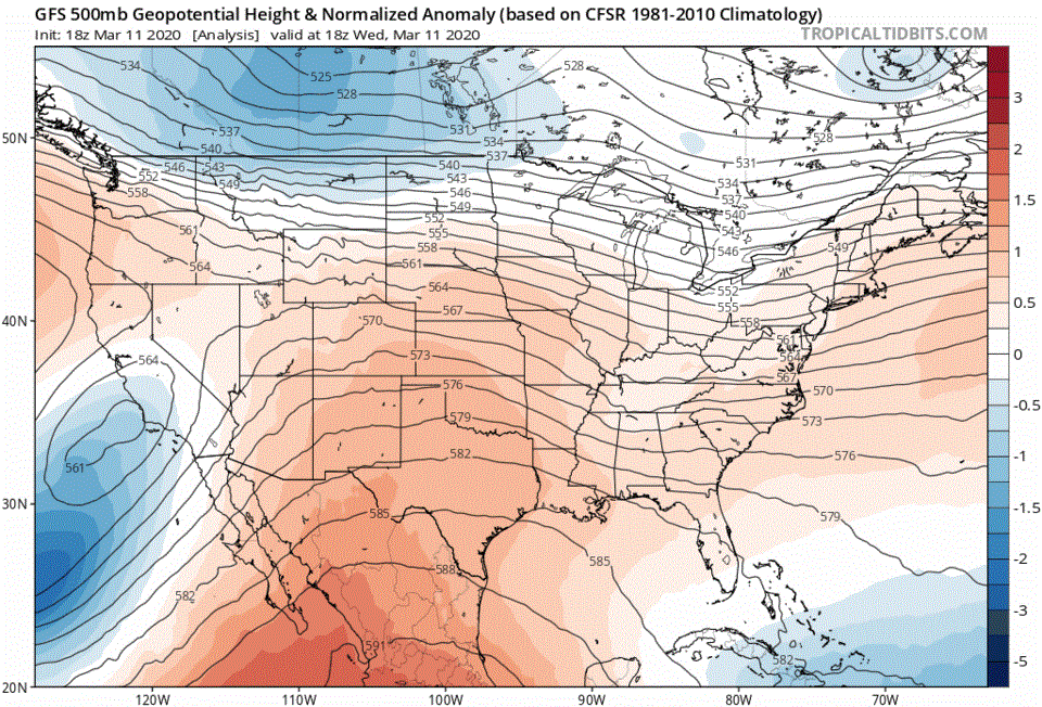
You can watch the more northerly wobble of the Low for the next 10 days as the blue region with concentric circles of 500mb heights to our southwest (Figure 4). It isn't until the end of the 10 days that the low is expected (now) to dig deeply south giving us lots of snow.
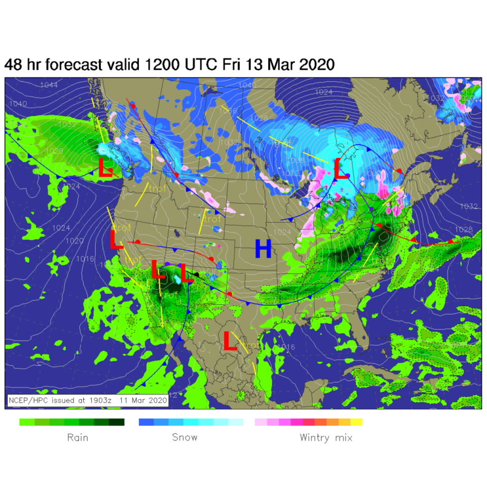
By Friday morning, the first surface low is sloshing ashore and dumping significant rain across Arizona (Figure 5). We might see snow at the start and end of the precipitation window that (for now) looks to run from Friday morning around 1am to 10pm Friday evening (Figure 2).
The Longer Range Forecast:
We get to enjoy a very warm and nice weekend with low precipitation chances Saturday through Monday afternoon (Figure 2). The next low ejects across the state Monday night and rain/snow chances continue all week. The coldest day comes Tuesday when cold air pushes up against the Rockies briefly (Figure 6). The mountain communities stay quite warm.
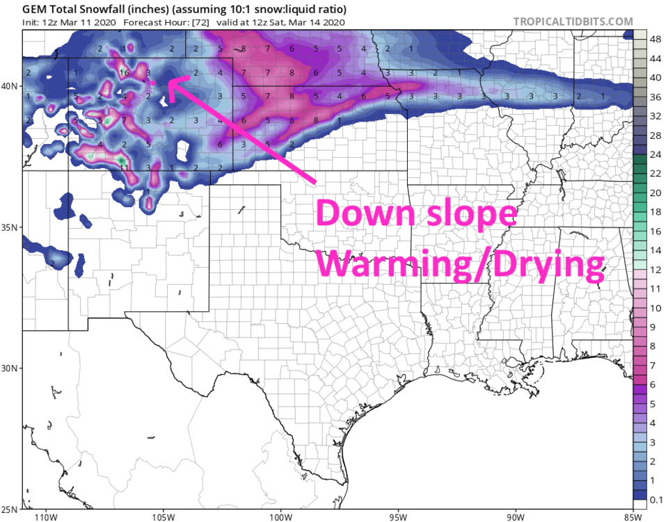
What makes it worse is that IF the low stays further north, then we'll have more westerly air flow across the state. That means that just downstream of the Rockies, we'll have down slope warming and drying of the air. That is visible in Figure 7 as a literal hole in the snow pattern over the next 5 days. There is a hole in the rainfall pattern as well (not shown). The GEM thinks things will be colder Friday and gives us about 1-3 inches of snow by Saturday.
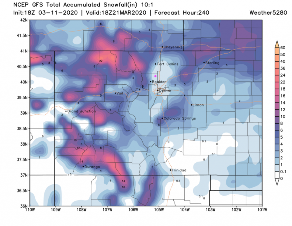
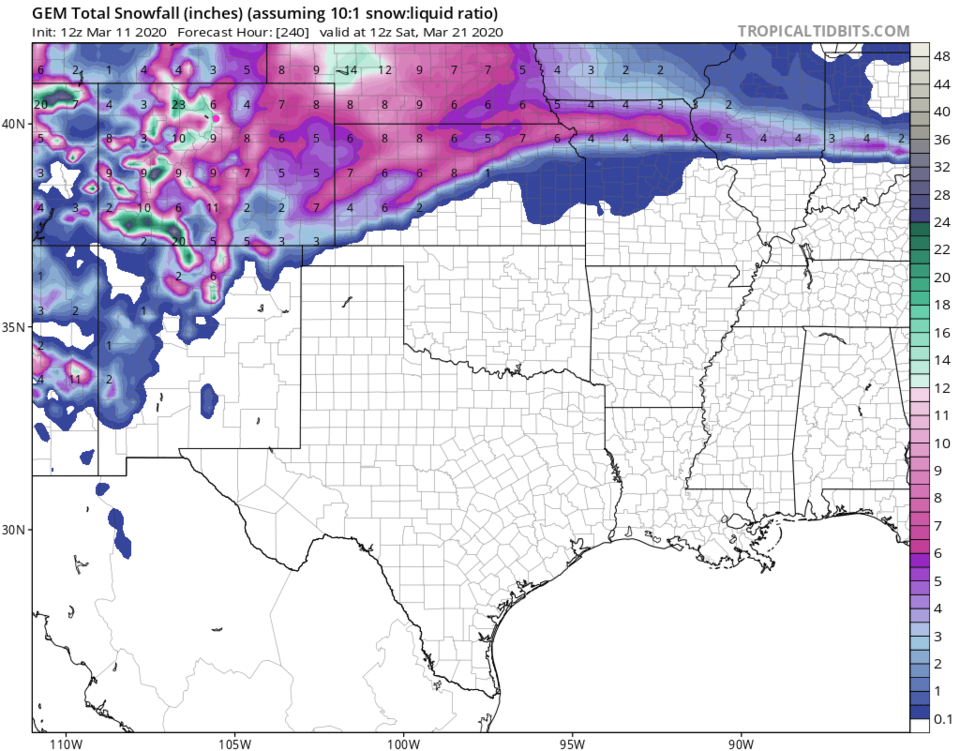
Looking much further out, that storm track still robs Longmont of snow and rain (Figure 9) but gives the mountains some good accumulation. The GEM is still colder (with a more southerly storm track) and seems to give Longmont 10-14 inches of snow (Figure 10). I'm guessing that is quite unrealistic. We'll watch this marginal weather system more as the weekend approaches. IF the low starts to trend southward again, look for snow chances to return.