Skip to content

Next Storm/Next Snow Forecast Discussion from the Cherrywood Observatory – March 14, 2019

This content was originally published by the Longmont Observer and is licensed under a Creative Commons license.

Forecast Discussion:

NOTE: The snow reports will be included in tomorrow's post (March 15).

I'll post this now and update with snow/rain reports in the morning.

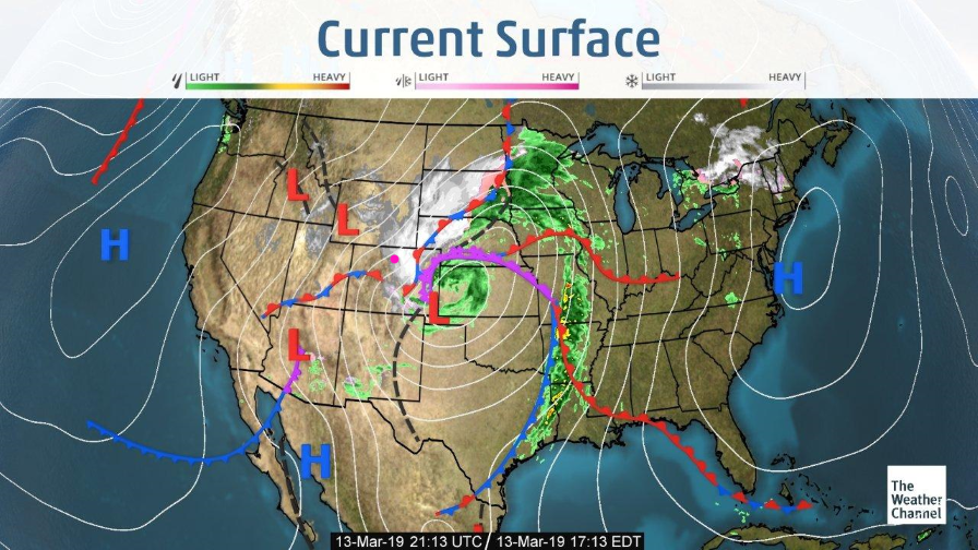
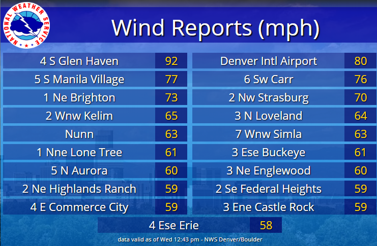
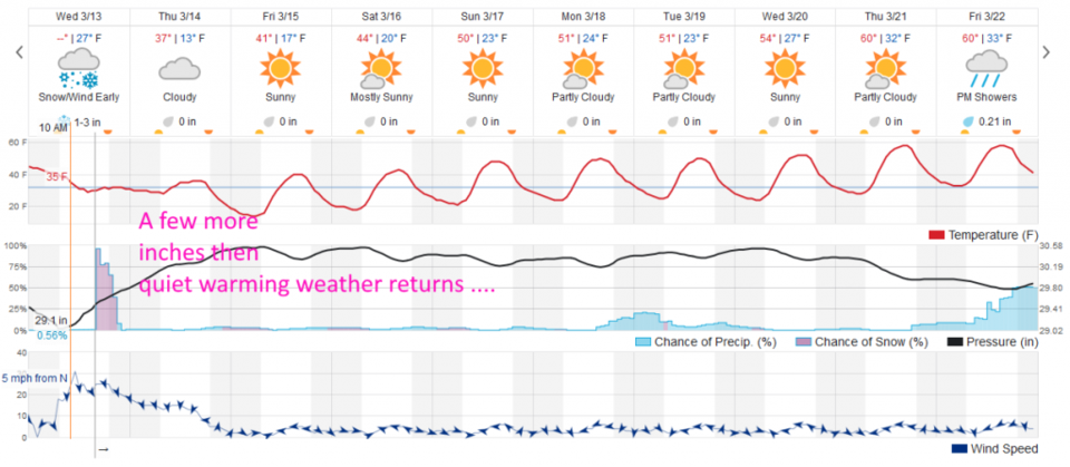
The giant low that deepened in Colorado and moved on into Kansas (Figure 1). By about 11am the atmospheric pressure had dropped 34mb over southeast Colorado. Wind speeds seen up through midday were impressive (Figure 2). There still will be about 1-3 inches of snow to fall as the system winds down (and down slope flow starts to matter). It should be all over in Longmont before midnight (this was posted at 4pm Wednesday).

The longer range forecast:

We warm through the 40's F by the weekend, the 50's by mid-week next week, and touch 60F by the end of next week. Nice.

Figure 1: The current surface map from Wednesday PM and the Weather Channel.
Figure 2: Wind reports in the first half of the Wednesday blizzard from the NWS Boulder.
Figure 3: the graphical forecast for the next 10 days for Longmont, CO from weatherunderground.com

Current Weather

Mostly cloudy

Mostly cloudy

57°F

UV Index
1 Low
Pressure
29.93 Rising
Visibility
8 miles
Dewpoint
29 °F
Humidity
35%
Wind
NNE 9 mph
Gust
19.1 mph
Wind Chill
57 °F

Hourly Forecast

Today
7 PM
55°F
Partly sunny
Today
8 PM
53°F
Partly cloudy
Today
9 PM
50°F
Partly cloudy
Today
10 PM
47°F
Partly cloudy
Today
11 PM
45°F
Partly cloudy
Tomorrow
12 AM
43°F
Partly cloudy
Tomorrow
1 AM
41°F
Partly cloudy
Tomorrow
2 AM
41°F
Partly cloudy w/ showers
Tomorrow
3 AM
40°F
Partly cloudy w/ showers
Tomorrow
4 AM
39°F
Partly cloudy
Tomorrow
5 AM
39°F
Partly cloudy
Tomorrow
6 AM
37°F
Partly sunny

7 Day Forecast

Partly sunny

Friday

76 °F

More sunshine than clouds; breezy this afternoon


Partly cloudy w/ showers

Friday Night

37 °F

Partly cloudy with a couple of showers late


Partly sunny

Saturday

66 °F

Not as warm with sun and some clouds


Mostly clear

Saturday Night

39 °F

Clear to partly cloudy


Mostly cloudy

Sunday

76 °F

Mostly cloudy and warmer; breezy in the afternoon


Mostly cloudy

Sunday Night

51 °F

Rather cloudy; windy late


Windy

Monday

60 °F

Winds gusting past 40 mph; cloudy and cooler


Intermittent clouds

Monday Night

43 °F

Breezy in the evening; otherwise, partly cloudy


Intermittent clouds

Tuesday

62 °F

Times of clouds and sun; windy in the afternoon


Intermittent clouds

Tuesday Night

36 °F

Clearing


Sunrise and Sunset

Sunrise
5:57 AM
Sunset
7:58 PM

Based on AccuWeather data