Skip to content

Next Storm/Next Snow Forecast Discussion from the Cherrywood Observatory – March 26, 2019

This content was originally published by the Longmont Observer and is licensed under a Creative Commons license.

Forecast Discussion:

To use an old joke of mine; I'm issuing a nice-weather alert for today and tomorrow (Tue and Wed). We have high pressure over the state (and a big ridge aloft). We break 70F today. Wonderful. Tomorrow will be even warmer.

The longer range forecast:

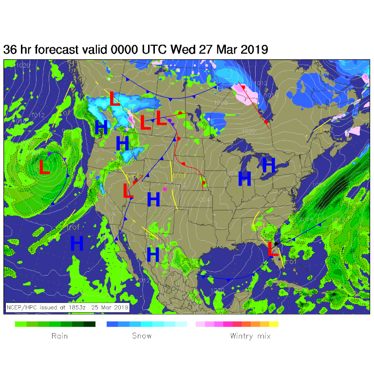
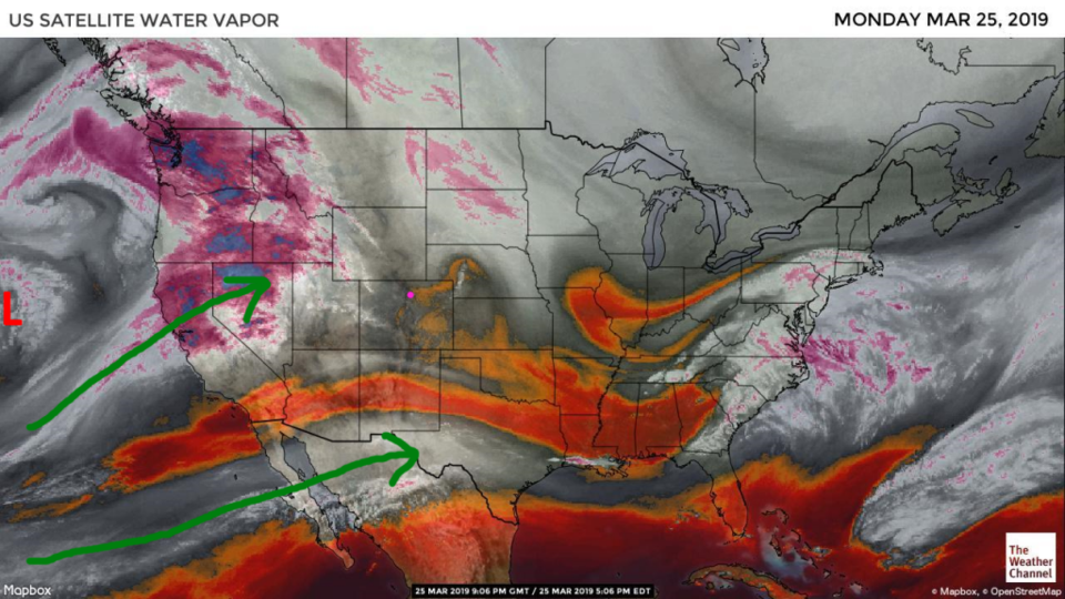
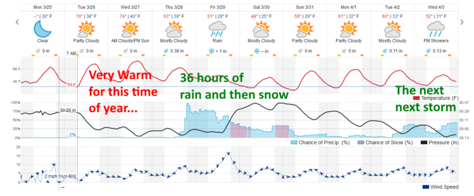
Our big, approaching, late week Spring storm is visible out in the Pacific in Figure 1 and in Figure 2, the water vapor satellite image. The rivers of moisture from the warm (El Nino) tropics are flowing up shown by the dark green arrows. Figure 3 is our standard 10 day graphical glance and the wonderful warmth holds even into Thursday AM before the next system splashes in.

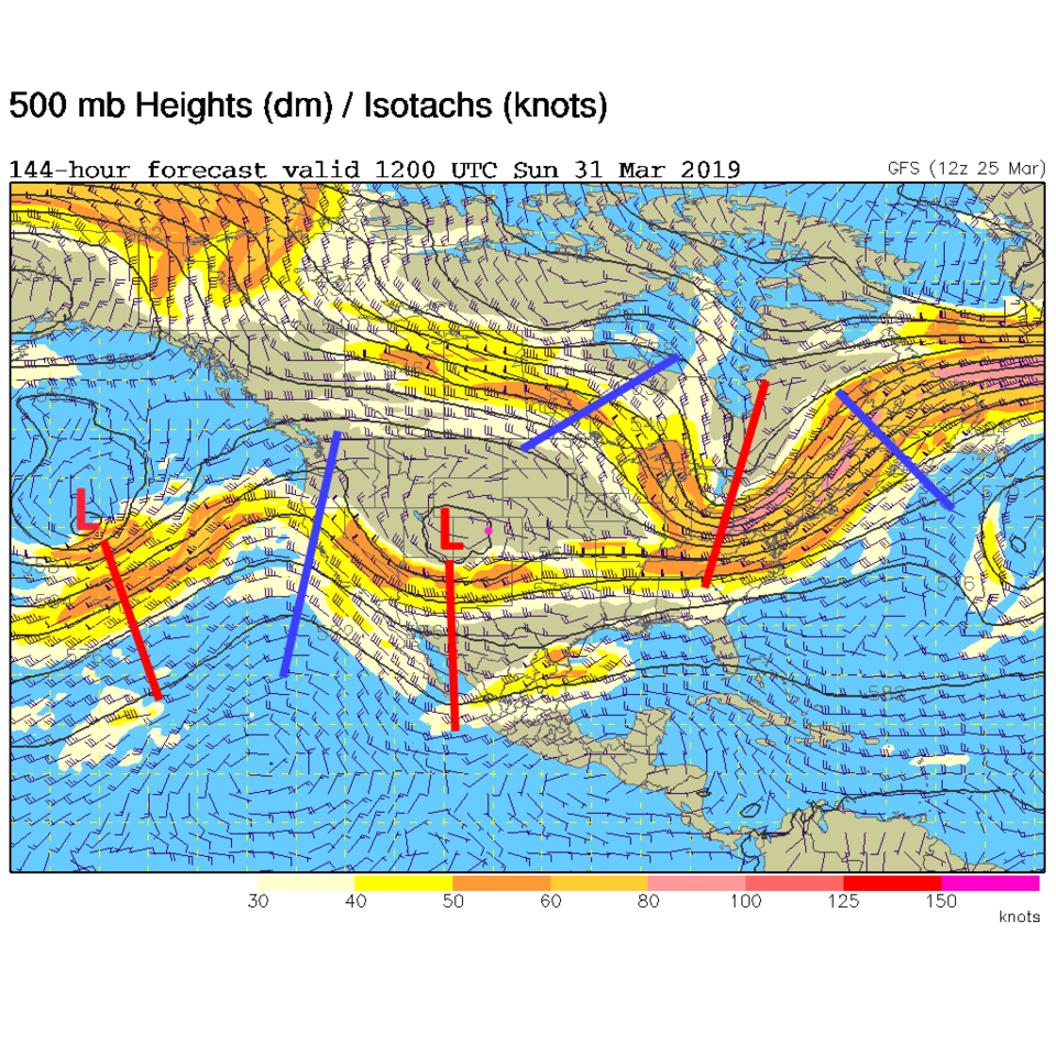
Figure 3 shows a day and a half of robust precipitation chances with another batch of energy moving in Saturday overnight. The upper air map for Sunday morning shows the closed low right overhead and fairly strong trough in place (Figure 4). Temperatures are fairly warm, for a storm, this time of year.

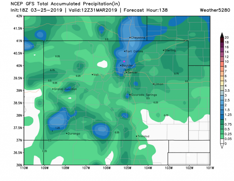
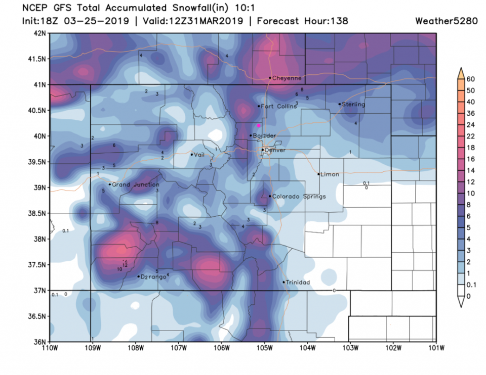
We'll look at a wider range of models in later posts this week, but the weatherunderground model and GFS are good early indicators of what might happen. The weatherunderground model has 4/10ths of an inch of rain and less than an inch of snow by Sunday morning. This seems very under-done to me.

The GFS (Figure 5) has a very healthy 1.5 inches of water and 3-4 inches of snow by Sunday morning. That might be over-done, but, again, we'll keep an eye on it. I'm planning on the first camping outing of the year... I might need ponchos.

Figure 1: The forecast surface map for Tuesday PM from NCEP.
Figure 2: The water vapor satellite image from Monday night from NOAA. Longmont is the pink dot.
Figure 3: the graphical forecast for the next 10 days for Longmont, CO from weatherunderground.com
Figure 4: The 500mb forecast upper air analysis for Sunday AM. Pink dot is Longmont. Red lines are troughs, blue lines are ridges.
Figure 5 : the forecast accumulated precipitation map from the GFS and weather5280.com for Colorado, through Sunday AM.
Figure 6 : the forecast accumulated snow map from the GFS and weather5280.com for Colorado, through Sunday AM.

Current Weather

Sunny

Sunny

48°F

UV Index
4 Moderate
Pressure
30.01 Falling
Visibility
7 miles
Dewpoint
25 °F
Humidity
41%
Wind
SE 3.8 mph
Gust
9.5 mph
Wind Chill
47 °F

Hourly Forecast

Today
10 AM
51°F
Mostly sunny
Today
11 AM
55°F
Mostly sunny
Today
12 PM
58°F
Mostly sunny
Today
1 PM
60°F
Partly sunny
Today
2 PM
62°F
Intermittent clouds
Today
3 PM
63°F
Mostly cloudy
Today
4 PM
65°F
Mostly cloudy
Today
5 PM
63°F
Cloudy
Today
6 PM
62°F
Cloudy
Today
7 PM
59°F
Mostly cloudy
Today
8 PM
56°F
Mostly cloudy
Today
9 PM
53°F
Mostly cloudy

7 Day Forecast

Mostly cloudy

Thursday

65 °F

Becoming cloudy


Mostly cloudy

Thursday Night

36 °F

Mostly cloudy


Partly sunny

Friday

70 °F

Partial sunshine


Partly cloudy

Friday Night

38 °F

Partly cloudy


Partly sunny

Saturday

66 °F

Partial sunshine


Mostly clear

Saturday Night

41 °F

Clear to partly cloudy


Mostly cloudy

Sunday

76 °F

Rather cloudy; breezy in the afternoon


Intermittent clouds

Sunday Night

43 °F

Partly cloudy


Cloudy

Monday

60 °F

Cloudy and cooler with a shower in spots; windy in the afternoon


Mostly cloudy

Monday Night

43 °F

Breezy in the evening; otherwise, mostly cloudy


Sunrise and Sunset

Sunrise
5:58 AM
Sunset
7:57 PM

Based on AccuWeather data