Skip to content

Next Storm/Next Snow Forecast Discussion from the Cherrywood Observatory – March 7, 2019

This content was originally published by the Longmont Observer and is licensed under a Creative Commons license.

Forecast Discussion:

Our small storm is underway Wednesday pm (Figure 1 is the radar from 7:40 pm). As of 10 pm, we only have a dusting outside, but a bit more may fall before 1-2 am.

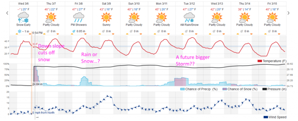
Figure 2 shows that down slope will cut off the precipitation around 2 am at the latest. Your car window and the roads might be slick and icy in the morning, but there shouldn't be anything to shovel.

Figure 3, the HRRR model shows that through 11 am, we could get a dusting to 1/2 inch. Figure 4, the GFS, also shows the remaining hours of the storm giving us a coating or a bit more of snow.

The longer range forecast:

Starting tomorrow, we'll try to figure out how much rain/snow comes in Friday night. Normal high temperatures now are 52°F. We'll be a bit below normal for the next 10 days. That storm next Monday/Tuesday? We'll talk about that after the next storm, Friday, has passed.

Figure 1: The current radar from 7:40pm Wednesday from Radar Scope iOS app.
Figure 2: the graphical forecast for the next 10 days for Longmont, CO from weatherunderground.com
Figure 3: the HRRR snowfall prediction up to 11am Thursday from weather5280.com
Figure 4: the forecast accumulated snow map from the GFS and weather5280.com for Colorado, through the next 2 days.

Current Weather

Mostly cloudy

Mostly cloudy

64°F

UV Index
2 Low
Pressure
29.85 Falling
Visibility
8 miles
Dewpoint
37 °F
Humidity
37%
Wind
NW 3.4 mph
Gust
9.1 mph
Wind Chill
64 °F

Hourly Forecast

Today
5 PM
63°F
Mostly cloudy
Today
6 PM
61°F
Mostly cloudy
Today
7 PM
58°F
Intermittent clouds
Today
8 PM
54°F
Intermittent clouds
Today
9 PM
51°F
Intermittent clouds
Today
10 PM
48°F
Intermittent clouds
Today
11 PM
45°F
Intermittent clouds
Tomorrow
12 AM
44°F
Partly cloudy
Tomorrow
1 AM
42°F
Partly cloudy
Tomorrow
2 AM
41°F
Partly cloudy
Tomorrow
3 AM
40°F
Partly cloudy
Tomorrow
4 AM
39°F
Partly cloudy

7 Day Forecast

Partly sunny w/ t-storms

Sunday

63 °F

Warmer with times of clouds and sun; a stray afternoon thundershower


Intermittent clouds

Sunday Night

37 °F

Partly cloudy


Partly sunny

Monday

70 °F

Partly sunny and pleasant


Intermittent clouds

Monday Night

43 °F

Partly cloudy


Mostly sunny

Tuesday

73 °F

Mostly sunny and pleasant


Intermittent clouds

Tuesday Night

41 °F

Clearing


Intermittent clouds

Wednesday

65 °F

Times of sun and clouds


Intermittent clouds

Wednesday Night

39 °F

A thundershower in spots in the evening; otherwise, partly cloudy


Rain

Thursday

53 °F

Cooler with occasional rain and drizzle; breezy in the morning


Partly cloudy

Thursday Night

32 °F

Partly cloudy


Sunrise and Sunset

Sunrise
6:03 AM
Sunset
7:53 PM

Based on AccuWeather data