Skip to content

Next Storm/Next Snow Forecast Discussion from the Cherrywood Observatory – March 8, 2019

This content was originally published by the Longmont Observer and is licensed under a Creative Commons license.

Forecast Discussion:

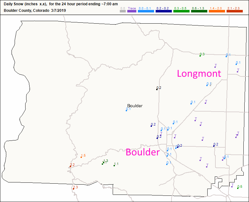
Looking quickly at the 7 am snow reports on Thursday - a trace to a quarter inch of snow/ice pellets and freezing drizzle coated the land from Boulder to Longmont (Figure 0). We also had an extended period of freezing fog in the morning. Denver picked up more ice/snow than we did as a convective band set up across the mountains into Denver proper. The avalanche danger continues to increase up in the high country.

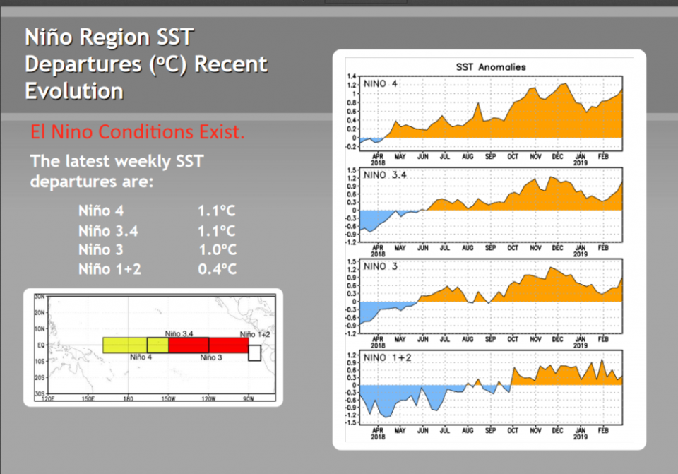
The world is officially in an El Niño state (it was in a sub-class of El Niño up until now - a Modoki El Niño - where the warm ocean anomaly was more located in the central Pacific than in the eastern side as we would expect - Figure 2).

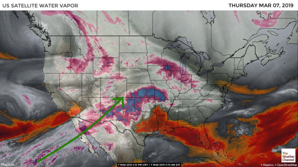
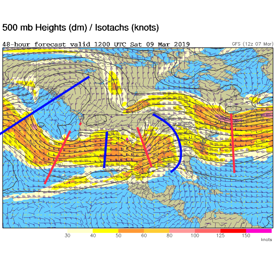
The upper-air pattern coupled with generous amounts of subtropical moisture keep the flow of moisture pouring into the west and southwest (Figure 3 - green arrow and white/purple clouds).

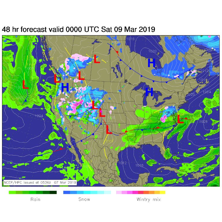
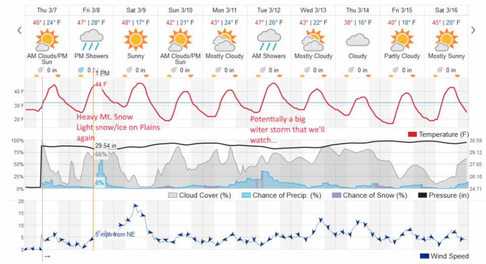
By tonight (Friday pm) another low will interact with that moisture and KEEP dumping snow on the mountains. (I think I heard Vail has roared past 300 inches of snow this season). (Figure 3) Similar to Wednesday/Thursday- the big stuff will fall in the mountains with some snow/ice out on the Plains. This is being kicked off by the short wave seen just past us Saturday morning as the red dash east of us in Figure 4).

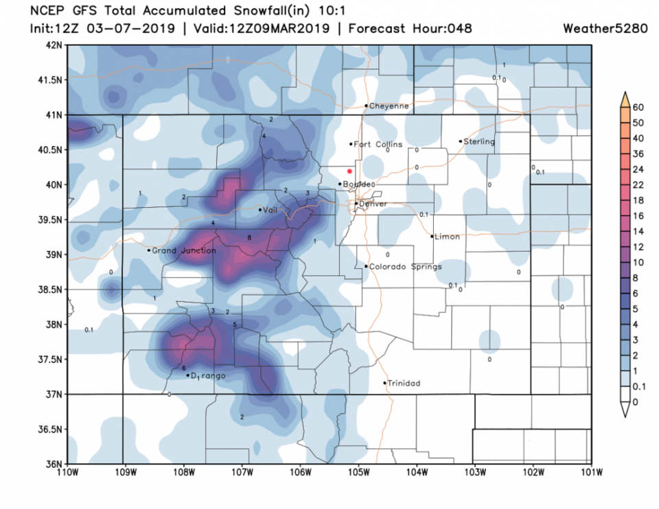
The period of time for low-land precipitation will be short again; afternoon and early evening Friday (Figure 5). Note, no real cold air gets pulled back to I-25 this time. The GFS shows a trace to a coating again along I-25 (Figure 6).

The longer range forecast:

We stay just a bit below normal for the next 10 days (Figure 4) and some models (there is a lot of disagreement) show a big cut off low forming in the SW U.S. that could drop real snow along the Front Range Monday-Wednesday next week.

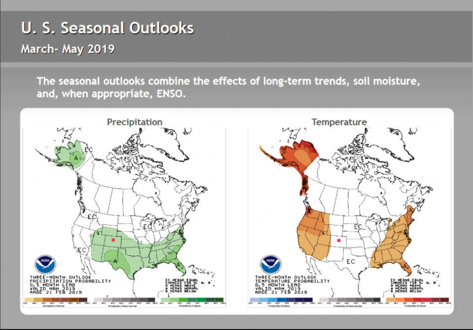
Looking back at the El Niño conditions - since these ocean temperatures and global wind field patterns are expected to remain in place this year, there is a longer range outlook to May posted by NOAA (Figure 7). They are calling for good chances of above normal precipitation over Colorado and near normal temperatures. (The WeatherBell forecasters are calling for above normal precipitation and below normal temperatures for most of Colorado). Both of these forecasts mean we probably have a good amount of snow yet to come. Keep that shovel ready.

Figure 0: total new snow totals for Wednesday/Thursday up to 7am for Boulder county from CoCoRaHS.
Figure 1: El Nino indicators/indices from a report by noaa.gov https://www.cpc.ncep.noaa.gov/products/analysis_monitoring/lanina/enso_evolution-status-fcsts-web.pdf
Figure 2: The water vapor satellite image from Thursday noon from NOAA. Longmont is the pink dot. The green arrow shows the flow of subtropical moisture into the west.
Figure 3: The forecast surface map for Wednesday noon from NCEP.
Figure 4: The 500mb forecast upper air analysis for Saturday AM. Pink dot is Longmont. Red lines are troughs, blue lines are ridges.
Figure 5: the graphical forecast for the next 10 days for Longmont, CO from weatherunderground.com
Figure 6: the forecast accumulated snow map from the GFS and weather5280.com for Colorado, through the next 2 days.
Figure 7: El Nino cause precipitation and temperature anomaly forecast from a report by noaa.gov https://www.cpc.ncep.noaa.gov/products/analysis_monitoring/lanina/enso_evolution-status-fcsts-web.pdf

Current Weather

Mostly cloudy

Mostly cloudy

57°F

UV Index
2 Low
Pressure
29.63 Falling
Visibility
8 miles
Dewpoint
27 °F
Humidity
31%
Wind
WSW 9.2 mph
Gust
21.2 mph
Wind Chill
57 °F

Hourly Forecast

Today
4 PM
57°F
Showers
Today
5 PM
56°F
Mostly cloudy
Today
6 PM
56°F
Intermittent clouds
Today
7 PM
53°F
Intermittent clouds
Today
8 PM
51°F
Intermittent clouds
Today
9 PM
48°F
Partly cloudy
Today
10 PM
45°F
Partly cloudy
Today
11 PM
43°F
Partly cloudy
Tomorrow
12 AM
41°F
Mostly clear
Tomorrow
1 AM
40°F
Mostly clear
Tomorrow
2 AM
39°F
Mostly clear
Tomorrow
3 AM
38°F
Mostly clear

7 Day Forecast

Partly sunny w/ showers

Tuesday

60 °F

Times of clouds and sun with a couple of brief showers beginning at midday; windy


Partly cloudy

Tuesday Night

35 °F

Partly cloudy and colder; there can be frost in the normally colder spots


Intermittent clouds

Wednesday

58 °F

Cool with times of clouds and sun


Mostly cloudy w/ showers

Wednesday Night

39 °F

Increasing clouds with a shower in spots late


Partly sunny w/ showers

Thursday

56 °F

Times of clouds and sun with a couple of showers; cool


Partly cloudy

Thursday Night

40 °F

Partly cloudy


Mostly cloudy

Friday

63 °F

Mostly cloudy and warmer


Clear

Friday Night

42 °F

Clear


Mostly sunny

Saturday

68 °F

Mostly sunny


Mostly clear

Saturday Night

43 °F

Mainly clear


Sunrise and Sunset

Sunrise
5:52 AM
Sunset
8:02 PM

Based on AccuWeather data