Skip to content

Next Storm/Next Snow Forecast Discussion from the Cherrywood Observatory – May 18-19, 2019

This content was originally published by the Longmont Observer and is licensed under a Creative Commons license.

In Brief:

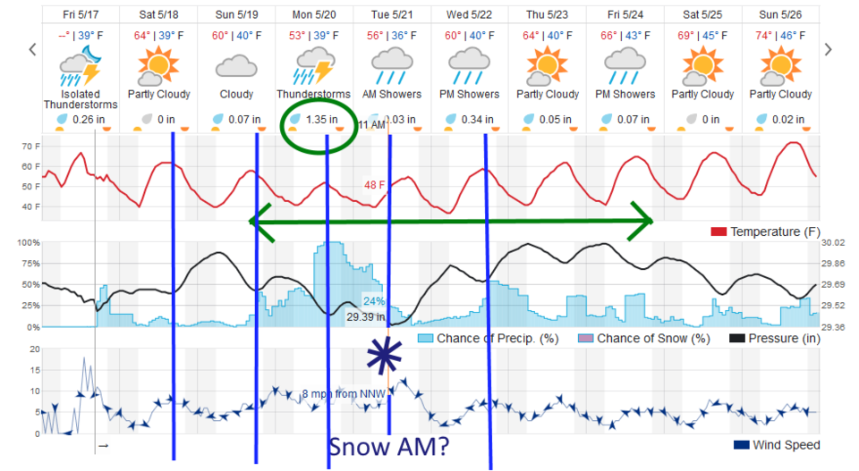
The heavy storms have moved out. The cool down has begun. Repeated cool fronts will keep us chilly (50'sF and 60'sF for highs ) this weekend and next week. Rain chances are small through the rest of the weekend but pick up again Sunday night with another cool front. Monday into Tuesday looks like a very wet period with over an inch of rainfall. Tuesday AM has the best chance for snow near I-25 locations.

Forecast Discussion:

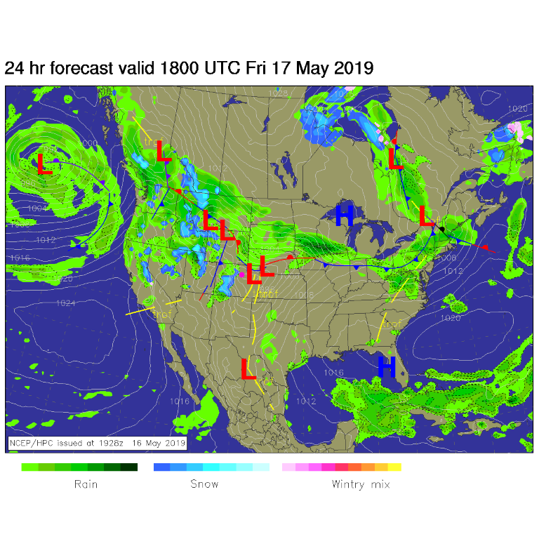
If there are some storm reports in the morning (hail, damaging winds, or tornadoes), I'll update this site. There are fronts and low pressure systems wandering around the state this weekend (Figure 1). We have a cool weekend ahead with some rain chances now and then - but a front coming Sunday will increase rain chances Sunday PM

The Longer Range Forecast:

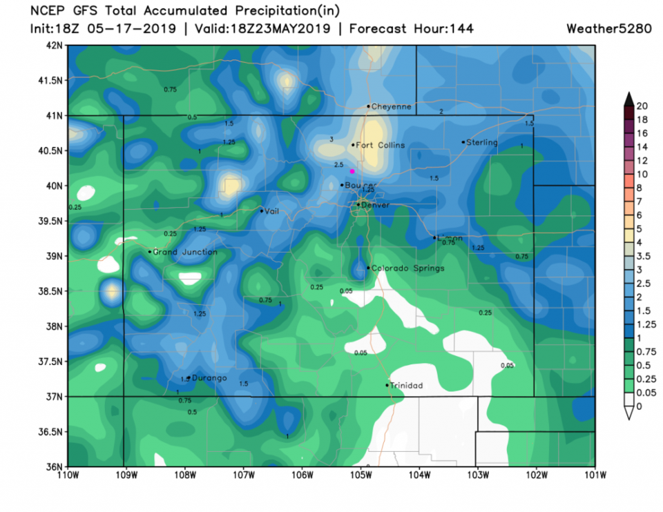
Front after outflow boundary after front will move across the state as we cool to highs only in the lower 50'sF Monday/Tuesday. The best rain totals will occur these days too- with ~1.40 inches of rainfall just these two days. The weatherunderground.com model gives us about 1.90 inches of rain up through Thursday. (Figure 2)

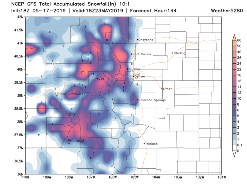
The GFS goes a bit crazy (which we should expect by now) with 2.50 inches of water before midday Thursday (Figure 3). The mountains get a foot or more of snow at higher elevations and a measurable amount of snow hits Ft. Collins, Lyons, Boulder, western Denver, and the Palmer Divide this week.

Figure 1: The forecast surface map for Saturday noon from NCEP.
Figure 2: the graphical forecast for the next 10 days for Longmont, CO from weatherunderground.com
Figure 3: the forecast accumulated precipitation map from the GFS and weather5280.com for Colorado,over the next 5.5 days.
Figure 4: the forecast accumulated snowfall map from the GFS and weather5280.com for Colorado,over the next 5.5 days.

Current Weather

Sunny

Sunny

63°F

UV Index
1 Low
Pressure
29.95 Falling
Visibility
8 miles
Dewpoint
38 °F
Humidity
39%
Wind
N 3.3 mph
Gust
7 mph
Wind Chill
63 °F

Hourly Forecast

Today
7 PM
63°F
Intermittent clouds
Today
8 PM
60°F
Mostly clear
Today
9 PM
57°F
Mostly clear
Today
10 PM
54°F
Mostly clear
Today
11 PM
51°F
Mostly clear
Tomorrow
12 AM
49°F
Mostly clear
Tomorrow
1 AM
48°F
Mostly clear
Tomorrow
2 AM
46°F
Mostly clear
Tomorrow
3 AM
45°F
Mostly clear
Tomorrow
4 AM
43°F
Mostly clear
Tomorrow
5 AM
42°F
Mostly clear
Tomorrow
6 AM
39°F
Mostly sunny

7 Day Forecast

Intermittent clouds

Saturday

64 °F

Cooler with clouds yielding to sun


Mostly clear

Saturday Night

39 °F

Clear to partly cloudy


Mostly cloudy

Sunday

78 °F

Cloudy most of the time, breezy and warmer


Mostly cloudy

Sunday Night

47 °F

Rather cloudy and windy


Windy

Monday

60 °F

Very windy; cloudy and cooler


Intermittent clouds

Monday Night

41 °F

Partly cloudy


Intermittent clouds

Tuesday

59 °F

Cool with times of clouds and sun; windy in the afternoon


Partly cloudy

Tuesday Night

32 °F

Partly cloudy


Intermittent clouds

Wednesday

60 °F

Times of clouds and sun


Intermittent clouds

Wednesday Night

35 °F

Partly cloudy


Sunrise and Sunset

Sunrise
5:55 AM
Sunset
7:59 PM

Based on AccuWeather data