Skip to content

Next Storm/Next Snow Forecast Discussion from the Cherrywood Observatory – May 23, 2019

This content was originally published by the Longmont Observer and is licensed under a Creative Commons license.

In Brief:

With another piece of the storm passing over Colorado - an elevated chance of cold showers will continue Wednesday PM to Thursday PM. There is a chance of a rain/snow mix in the dark-time hours. The weekend looks pretty nice with seasonally warm temperatures and only a chance of afternoon showers. Some rain and cool weather returns starting Monday night (Memorial Day).

Forecast Discussion:

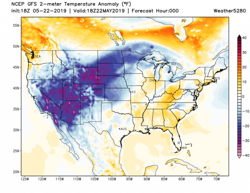
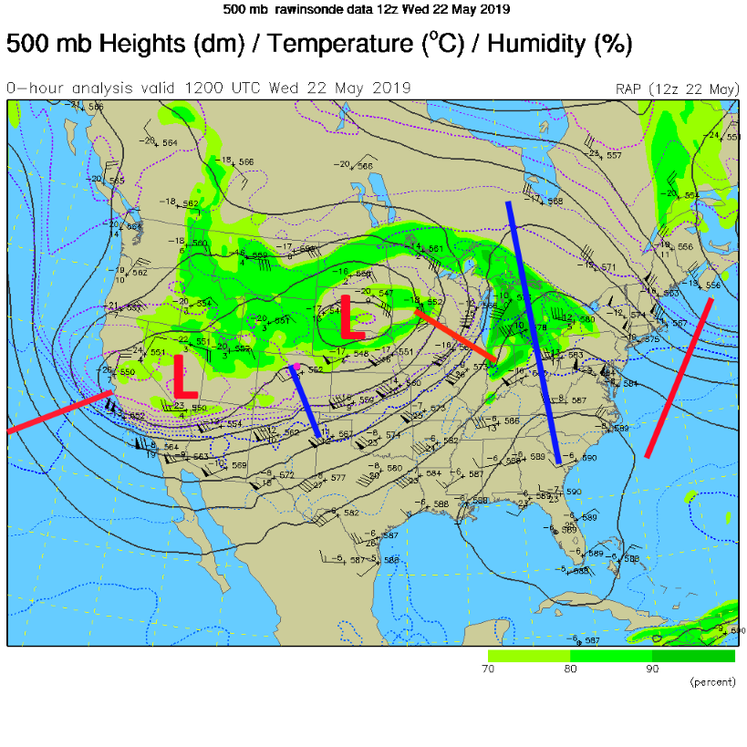
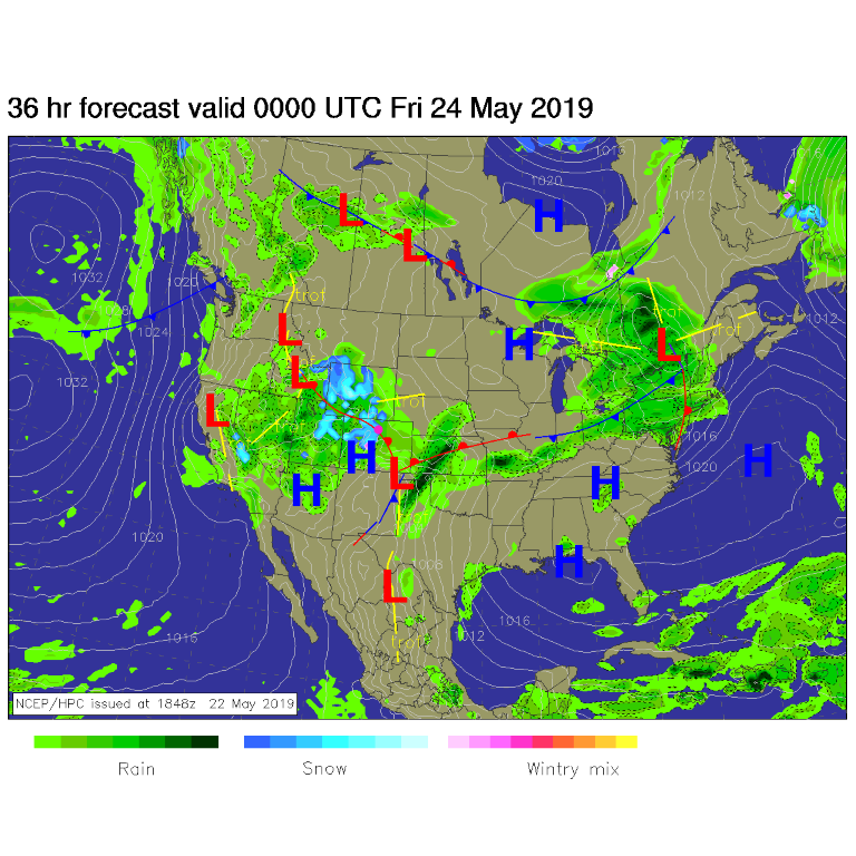
There is a lot of abnormally cold air stretched from southern California up to northern Minnesota (Figure 1). This region of depressed temperatures mirror the center of a double-lobed low pressure aloft dominating the West (Figure 2). As the second lobe rotates through, we will see rain chances pick up some - but only a 1/10th to maybe 1/4th inch of new water is expected (Figure 3). It might be cold enough Thursday morning and later Thursday night for snow to mix in with the rain over Longmont. It just won't end.

The Longer Range Forecast:

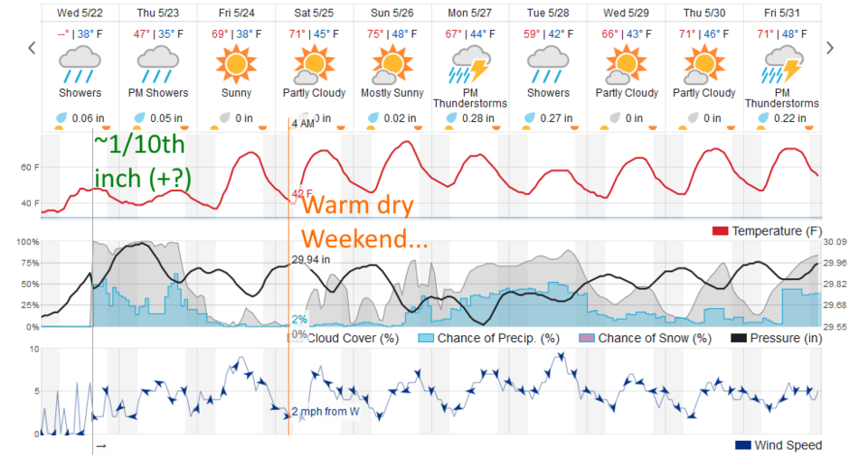
The ongoing showers taper off by the early pre-dawn hours Friday. We climb to 70F for Friday and the mid 70'sF by Sunday. Just afternoon thundershowers drifting off the high country are the main threat to picnics and sporting events (Figure 4). The BolderBoulder may see some drizzle and spotty rain. The better chance of thunderstorms and rain do hold off until later in the day. At the start of the race, the temperatures should be about 51F with partly cloudy skies and a 20% chance of rain.

Things do look wet and cool Monday through Wednesday morning.

Figure 1: the 'current' surface temperature departure from normal for the U.S. from Wednesday afternoon.
Figure 2: The current 500mb upper air analysis for Wednesday afternoon Pink dot is Longmont. Red lines are troughs, blue lines are ridges.
Figure 3: The forecast surface map for Thursday night from NCEP.
Figure 4: the graphical forecast for the next 10 days for Longmont, CO from weatherunderground.com

Current Weather

Clear

Clear

41°F

UV Index
0 Low
Pressure
29.73 Rising
Visibility
9 miles
Dewpoint
23 °F
Humidity
49%
Wind
SSW 2.9 mph
Gust
7.9 mph
Wind Chill
39 °F

Hourly Forecast

Tomorrow
12 AM
40°F
Mostly clear
Tomorrow
1 AM
39°F
Mostly clear
Tomorrow
2 AM
38°F
Mostly clear
Tomorrow
3 AM
37°F
Mostly clear
Tomorrow
4 AM
36°F
Mostly clear
Tomorrow
5 AM
36°F
Partly cloudy
Tomorrow
6 AM
35°F
Partly sunny
Tomorrow
7 AM
37°F
Intermittent clouds
Tomorrow
8 AM
41°F
Intermittent clouds
Tomorrow
9 AM
45°F
Intermittent clouds
Tomorrow
10 AM
48°F
Intermittent clouds
Tomorrow
11 AM
51°F
Intermittent clouds

7 Day Forecast

Partly sunny w/ showers

Tuesday

60 °F

Times of clouds and sun with a couple of brief showers beginning at midday; windy


Partly cloudy

Tuesday Night

35 °F

Partly cloudy and colder; there can be frost in the normally colder spots


Intermittent clouds

Wednesday

58 °F

Cool with times of clouds and sun


Mostly cloudy w/ showers

Wednesday Night

39 °F

Increasing clouds with a shower in spots late


Intermittent clouds

Thursday

56 °F

Cool with times of clouds and sun


Partly cloudy

Thursday Night

40 °F

Partly cloudy


Mostly cloudy

Friday

63 °F

Mostly cloudy and warmer


Clear

Friday Night

42 °F

Clear


Mostly sunny

Saturday

68 °F

Mostly sunny


Mostly clear

Saturday Night

43 °F

Mainly clear


Sunrise and Sunset

Sunrise
5:52 AM
Sunset
8:02 PM

Based on AccuWeather data