Skip to content

Next Storm/Next Snow Forecast Discussion from the Cherrywood Observatory – May 7, 2019

This content was originally published by the Longmont Observer and is licensed under a Creative Commons license.

In Brief:

The moisture is arriving, the cool fronts are arriving - it will rain a good amount over the next four days with temperatures dropping each day. We have a chance of morning snow Thursday and Friday. After that we dry out some and warm up a bit for the weekend.

Forecast Discussion:

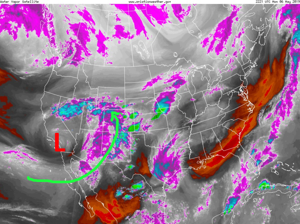
The water vapor satellite image (moist air is white/pink/teal, dry air is red/orange/black) shows that the center of the upper level low is coming on shore Monday PM. The river of tropical moisture (green arrow - Figure 1) is flowing northward ahead of the system. The air feels really moist outside and big storms formed east of I-25 to kick off this blustery wet week.

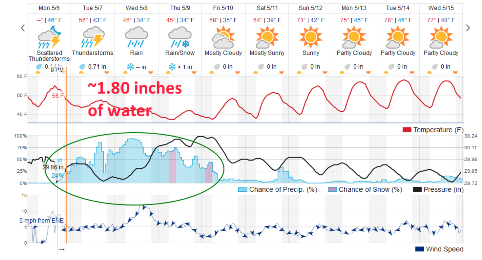
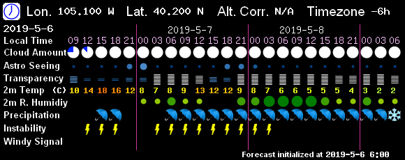
The graphical forecast in Figure 2 shows very little break in the high rain chances through Friday morning. Today (Tuesday) we should pick up our first 3/4ths of an inch of water. The GFS based output in Figure 3 shows storm chances Monday PM then storms returning by dawn.

The Longer Range Forecast:

The highs drop to the lower 40'sF Wed/Thur and we have a chance of early morning snow Thursday and Friday. According to the latest weatherundeground.com model output - we get an inch of snow Thursday AM.

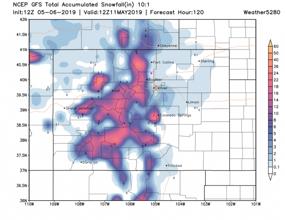
The GFS snowfall map - Figure 4 - gives us a coating to 1 inch over the course of this storm. The mountains pick up 1 to 1.5 feet. Wow.

Rainfall Roundup:

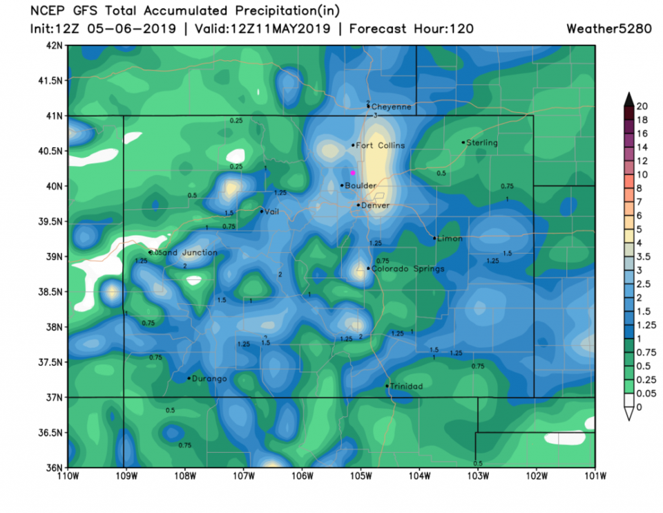
Figure 5 - the GFS gives us 1.25-1.5 inches of water over the next 5 days.
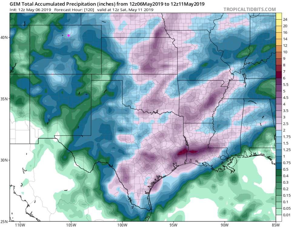
Figure 6 - the GEM gives us 1.75 to 2 inches of water over this time.
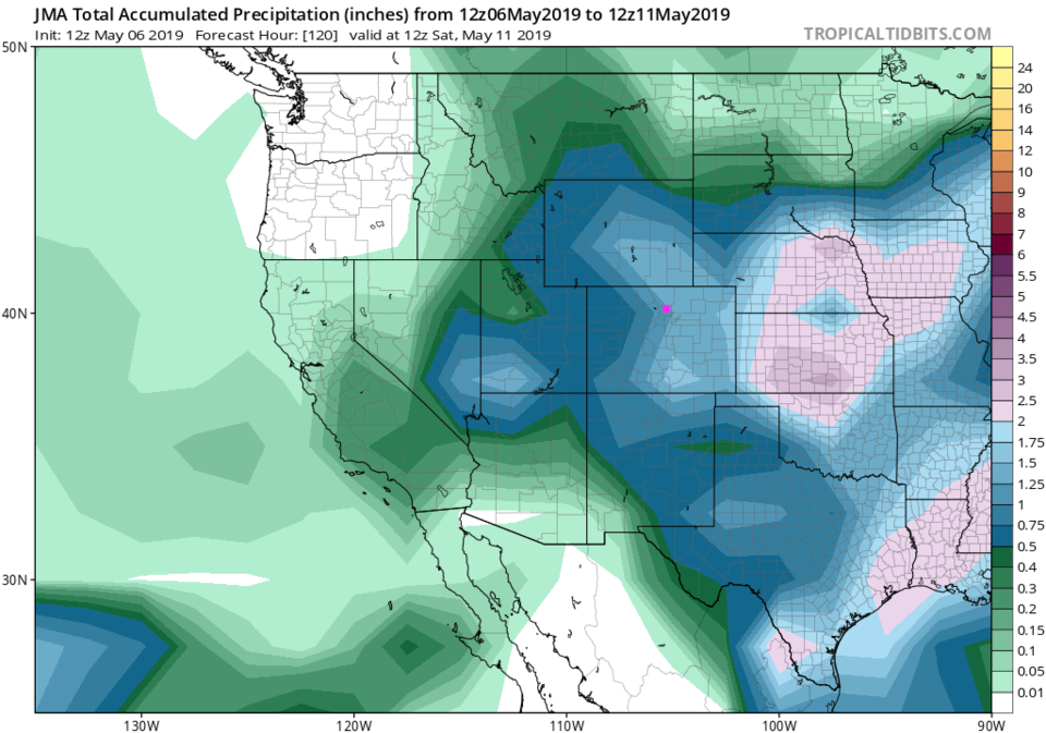
Figure 7 - the JMA (Japanese model) gives us 1.25-1.5 inches of water (a new model for this column).

Remember that the models went precipitation crazy before the last storm, and we only got about a third of that amount. Still, this will be a wet and chilly week. Keep warm and dry!

Figure 1: The water vapor satellite image from Monday night from NOAA and aviationweather.gov. Longmont is the pink dot.
Figure 2: the graphical forecast for the next 10 days for Longmont, CO from weatherunderground.com
Figure 3: 7Timer (GFS) forecast for sky conditions and precipitation type for the next 3 days for Longmont.
Figure 4: the forecast accumulated snowfall map from the GFS and weather5280.com for Colorado,over the next 5 days.
Figure 5: the forecast accumulated precipitation map from the GFS and weather5280.com for Colorado,over the next 5 days.
Figure 6: the forecast accumulated rainfall map from the GEM and tropicaltidbits.com for Colorado, through the next 5 days.
Figure 7: the forecast accumulated rainfall map from the JMA and tropicaltidbits.com for Colorado, through the next 5 days.


Current Weather

Light rain

Light rain

39°F

UV Index
1 Low
Pressure
29.89 Rising
Visibility
3 miles
Dewpoint
37 °F
Humidity
93%
Wind
NNE 3.3 mph
Gust
7 mph
Wind Chill
37 °F

Hourly Forecast

Today
10 AM
41°F
Rain
Today
11 AM
40°F
Rain
Today
12 PM
39°F
Rain
Today
1 PM
40°F
Rain
Today
2 PM
40°F
Cloudy
Today
3 PM
41°F
Rain
Today
4 PM
41°F
Rain
Today
5 PM
42°F
Cloudy
Today
6 PM
42°F
Rain
Today
7 PM
42°F
Rain
Today
8 PM
41°F
Rain
Today
9 PM
41°F
Cloudy

7 Day Forecast

Rain

Saturday

42 °F

Chilly with rain and a thunderstorm, some heavy early in the day; travel in the foothills and mountains will be slippery due to snow


Rain and snow

Saturday Night

36 °F

Cloudy with rain, mixed with a little snow late; travel in the foothills and mountains will be slippery due to snow


Thunderstorms

Sunday

60 °F

Mostly cloudy and warmer; a thundershower in spots in the afternoon


Partly cloudy w/ t-storms

Sunday Night

37 °F

A thunderstorm in spots in the evening; otherwise, partly cloudy


Partly sunny

Monday

71 °F

Partly sunny, pleasant and warmer


Intermittent clouds

Monday Night

42 °F

Partly cloudy


Mostly sunny

Tuesday

73 °F

Mostly sunny; pleasant in the afternoon


Mostly cloudy

Tuesday Night

40 °F

Mostly cloudy


Intermittent clouds

Wednesday

65 °F

Times of sun and clouds with a passing shower in the afternoon


Rain

Wednesday Night

35 °F

Overcast; a couple of evening showers followed by rain and drizzle late


Sunrise and Sunset

Sunrise
6:04 AM
Sunset
7:52 PM

Based on AccuWeather data