Skip to content

Next Storm/Next Snow Forecast Discussion from the Cherrywood Observatory – May 9, 2019

This content was originally published by the Longmont Observer and is licensed under a Creative Commons license.

In Brief:

Light rain will change to snow later this evening and snow will fall, now and then, through early afternoon Thursday when temperatures warm enough to turn it back to rain. We warm up and dry out by the weekend with nice weather most of next week.

Forecast Discussion:

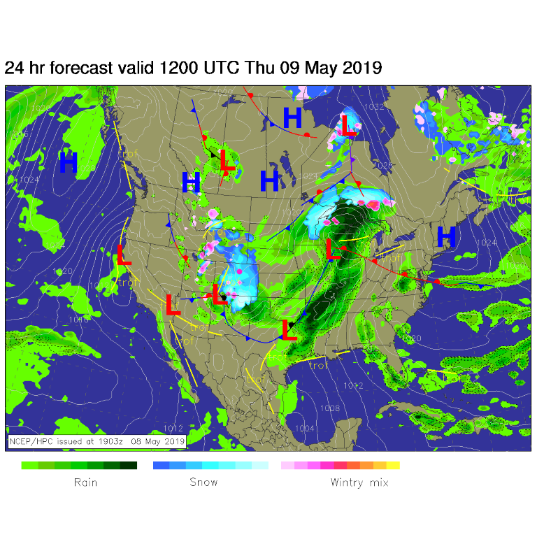
The surface map for Thursday AM (Figure 1) shows a big shield of snowfall over most of Colorado. Light rain should turn to snow about 9-10pm with snow showers continuing until around 1pm Thursday.

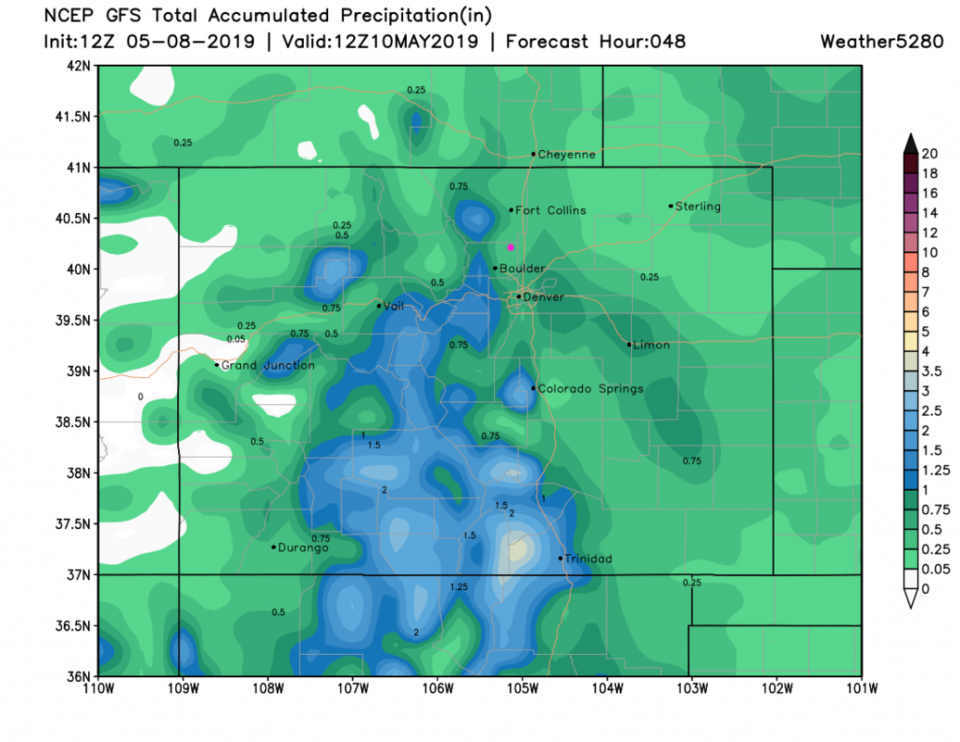
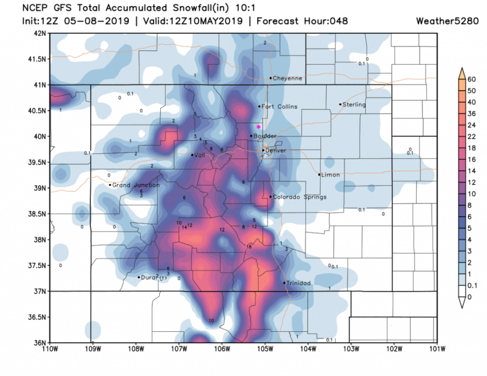
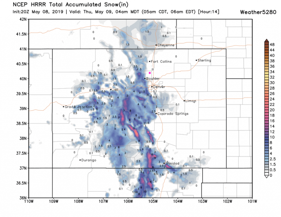
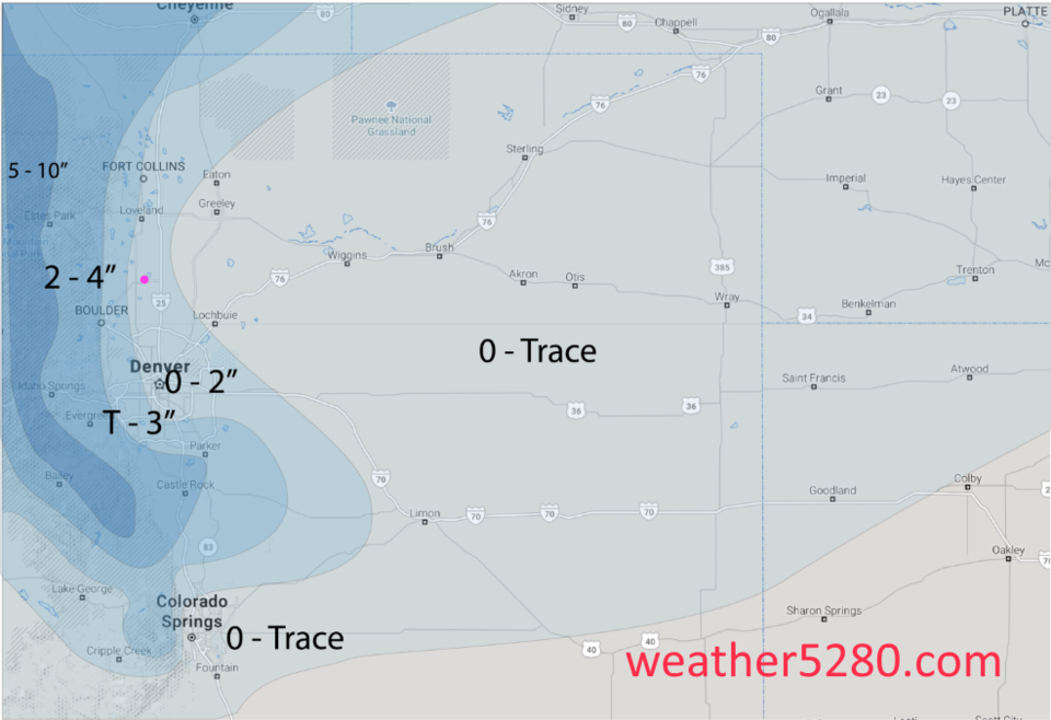
Longmont should pick up about 0.25-0.50 inch of water over the next 48 hours (Figure 3). For snowfall, the GFS gives us about 1 inch of snow (Figure 4). The HRRR model (which only runs through 4am Thursday - Figure 5) does not give Longmont measurable snow. The forecasters at wether5280.com are giving us 0-2 inches (Figure 6).

I'm calling for 1/2 to 3 inches on grassy cool surfaces (including elevated bridges and overpasses).

The Longer Range Forecast:

The storm pulls away (to the south and west!) Friday morning (when a bit more snow might fall - but not much to measure). We warm to the 70'sF by the end of the weekend and have nice weather on into next week. We'll look at afternoon storm chances in a future post.

Figure 1: The forecast surface map for Thursday AM from NCEP.
Figure 2: the graphical forecast for the next 10 days for Longmont, CO from weatherunderground.com
Figure 3: the forecast accumulated precipitation map from the GFS and weather5280.com for Colorado,over the next 2 days.
Figure 4: the forecast accumulated snowfall map from the GFS and weather5280.com for Colorado,over the next 2 days.
Figure 5: the forecast accumulated snowfall map from the HRR and weather5280.com for Colorado up to 4am Thursday.
Figure 6: the "hand drawn" snowfall forecast map from the forecasters at weather5280.com

Current Weather

Light rain

Light rain

50°F

UV Index
0 Low
Pressure
29.65 Steady
Visibility
7 miles
Dewpoint
44 °F
Humidity
80%
Wind
SSW 2.2 mph
Gust
6.1 mph
Wind Chill
50 °F

Hourly Forecast

Today
4 AM
50°F
Showers
Today
5 AM
51°F
Cloudy
Today
6 AM
51°F
Cloudy
Today
7 AM
52°F
Cloudy
Today
8 AM
55°F
Cloudy
Today
9 AM
60°F
Cloudy
Today
10 AM
62°F
Thunderstorms
Today
11 AM
65°F
Cloudy
Today
12 PM
68°F
Cloudy
Today
1 PM
67°F
Thunderstorms
Today
2 PM
70°F
Mostly cloudy
Today
3 PM
68°F
Mostly cloudy

7 Day Forecast

Mostly cloudy w/ showers

Thursday

72 °F

Turning cloudy, warm; an afternoon shower or two


Thunderstorms

Thursday Night

49 °F

Considerable cloudiness and mild; a thunderstorm in parts of the area in the evening followed by a brief shower or two late


Thunderstorms

Friday

70 °F

Mostly cloudy with a couple of thundershowers


Thunderstorms

Friday Night

45 °F

Cloudy with a couple of thundershowers


Rain

Saturday

48 °F

Chilly with periods of rain and a thunderstorm


Rain and snow

Saturday Night

39 °F

Cloudy with rain, mixed with a little snow late


Mostly cloudy

Sunday

59 °F

Mostly cloudy and warmer


Partly cloudy

Sunday Night

36 °F

Partly cloudy


Partly sunny

Monday

71 °F

Partly sunny, pleasant and warmer


Partly cloudy

Monday Night

45 °F

Partly cloudy


Sunrise and Sunset

Sunrise
6:07 AM
Sunset
7:50 PM

Based on AccuWeather data